(BIVN) – From this week’s USGS Hawaiian Volcano Observatory Volcano Watch article, written by University of Hawaiʻi at Hilo staff Meghann Decker and Lis Gallant, along with students Susan Richfield and Lichen Forster:
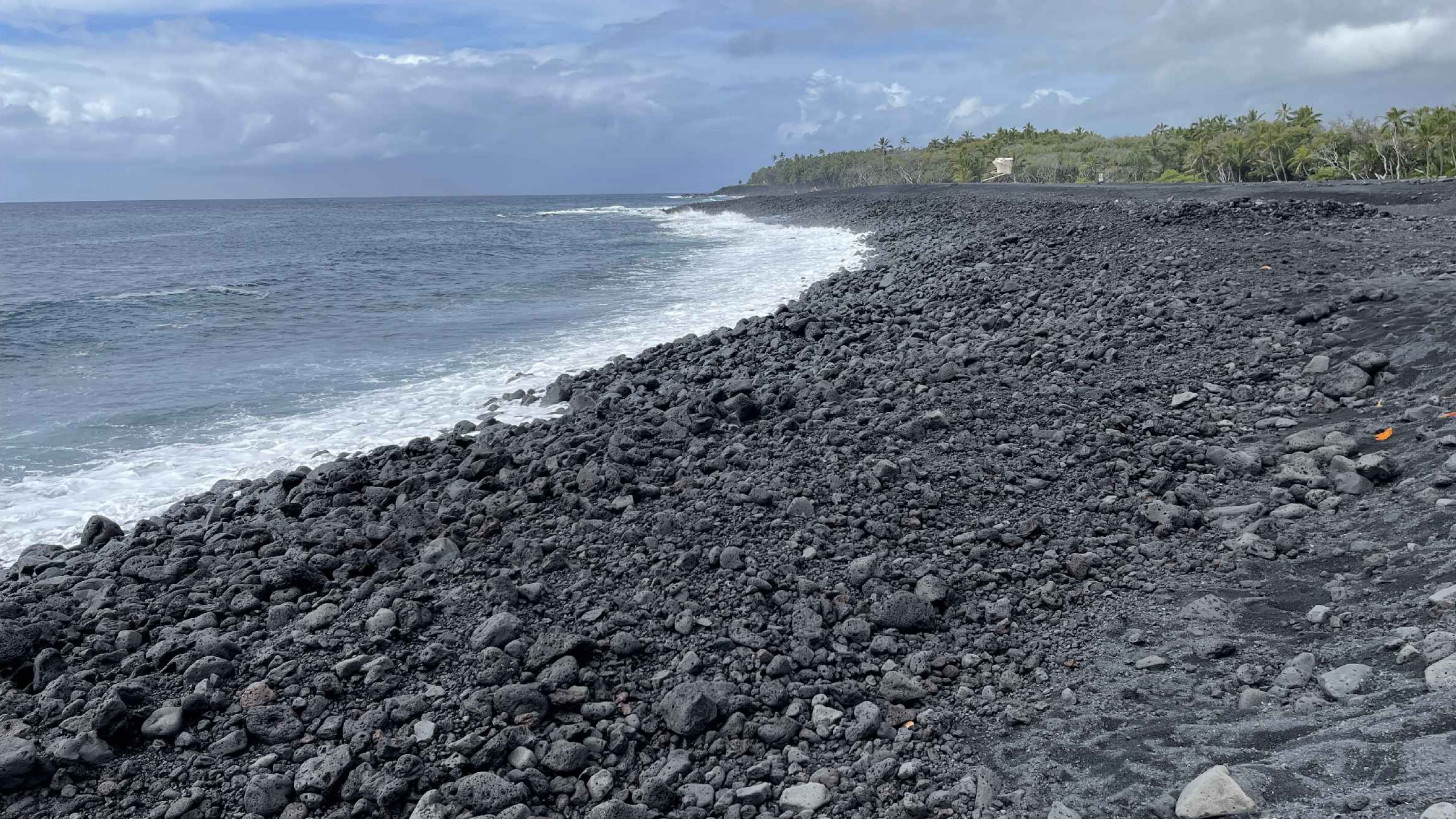
Although it may feel like it happened in an instant, the formation of the Island of Hawai‘i’s youngest black sand beach did not happen overnight. This week we explore how the beach at Pohoiki, near the easternmost point on the island, came to be and how it has grown over time.
Pohoiki, which means ‘little depression,’ has been an important ocean access point for people in the District of Puna. Before 2018, this area was a rocky coastline of Kīlauea lava flows emplaced 750–1,500 years ago. The boat ramp was constructed in 1963 and the breakwater in 1979, both by the United States Army Corps of Engineers.
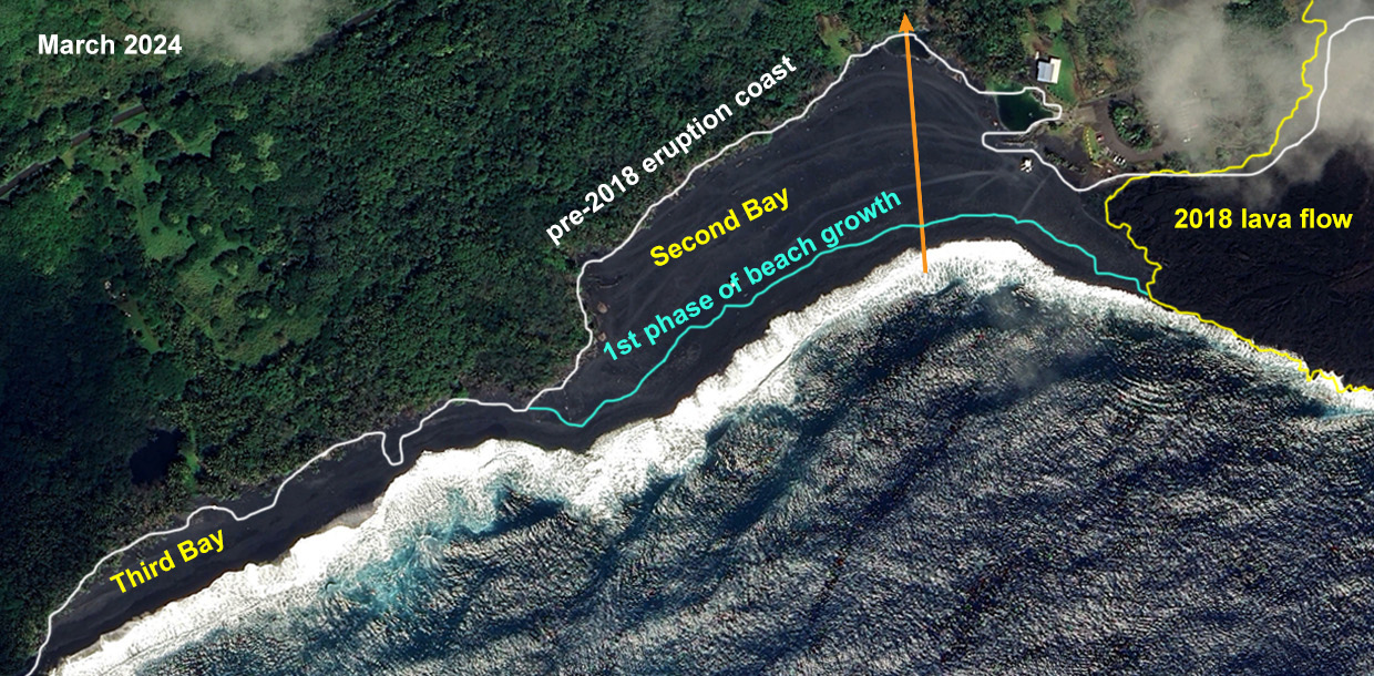
USGS: “Satellite image showing changes in the Pohoiki area on the Island of Hawaiʻi. The pre-2018 coastline is shown in white, extent of the first and second phase of growth in blue (about 1 year after the end of the 2018 eruption), and the current active phase as seen in the satellite image from March 2024.” (Satellite image from GoogleEarth)
The beach at Pohoiki grew rapidly in the year following the 2018 lower East Rift Zone eruption of Kīlauea and it has continued to evolve since then. The boat ramp was cut off from the ocean, and local warm springs formed in several low-lying areas.
The material that makes the beach at Pohoiki has a distinct black color and bumpy texture. It originally formed as molten lava poured into the ocean cooled and shattered into sand- to block-sized fragments. These fragments were then ground down even further by wave action and redistributed by the longshore current.
A longshore current flows parallel to the shore within the zone of breaking waves. They develop when waves approach a beach at an angle and can push sediments along the coastline. The typical longshore current on the east side of the Island of Hawai‘i transports material from the 2018 lava flows north of the beach and deposits it at Pohoiki. The first area of sediment accumulation in 2018 was around the boat ramp and breakwater.
The beach profile at Pohoiki has also experienced changes due to seasonal ocean swells. Overall, this has resulted in a bigger beach spanning further south into areas known as Second Bay and Third Bay. However, during the summer months, south swells disrupt the longshore current and move material from Third Bay to Second Bay. This results in steepening of the main beach face at Second Bay.
This seasonal reworking of sediment forms internal dune structures at Second Bay. Dune structures are landforms composed of wind- or water-driven particles that typically take the form of mounds, ridges, or hills. They can be found in coastal areas, deserts, and anywhere with large amounts of loose sediment and strong winds. Specifically, coastal dune structures form when wind and waves transport material from the beach inland, causing it to accumulate. Students from the University of Hawai‘i at Hilo recently conducted a Ground Penetrating Radar (GPR) survey of the beach in Second Bay to study these internal features.
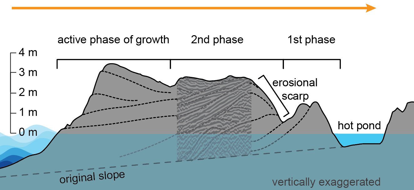
USGS: “A cross-section schematic of the beach in Second Bay, as seen in ground penetrating radar data. The orange arrow in each of the images and the cross-section represents a length of approximately 500 ft (152 meters).”
GPR is a technique that uses small radar pulses to detect objects and changes beneath the ground. When these pulses are transmitted into the ground, they encounter obstacles and reflect back towards the surface, where they are captured by a receiving antenna. GPR uses low-frequency radio waves no more powerful or harmful than those picked up by household radios.
The GPR survey showed that much of the beach growth was the result of migrating dunes. The first phase was dominated by primary dune structures built from the finer grained material created when the 2018 lava flows entered the ocean. This process of beach growth—called progradation—rapidly resulted in the filling in of Second bay and the accumulation of a beach face. Progradation is the process of a shoreline, delta, or fan growing towards the ocean over time.
The second phase of beach growth is characterized by continued progradation and sediment accumulation. The dune structures from this phase display cross-bedding. Cross-beds are formed as dunes migrate from erosion and redeposition of sediment. The first phase dunes also have cross beds, but at a higher angle; this tells us that the growth of the beach during the first phase was faster and more energetic than growth during the second phase.
The currently active phase of growth at the beach is characterized by stabilization of low-angle dune formation above sea-level that is affected by tide changes.
This GPR data represents what the beach looks like at one moment in time. With dredging to restore access to Pohoiki boat ramp planned for later this year, the shape and structure of the beach will continue to evolve.

by Big Island Video News
on at
STORY SUMMARY
POHOIKI, Hawaiʻi - This week, scientists examine how the Big Island's youngest black sand beach was built following the 2018 eruption of Kīlauea of the Lower East Rift Zone.