(BIVN) – The ongoing eruption at the summit of Kīlauea remains paused, and the USGS Volcano Alert level is WATCH.
No unusual activity has been noted along Kīlauea’s East Rift Zone or Southwest Rift Zone. The latest Volcano Watch article is about what happens after a rift zone intrusion.
From the today’s article, written by U.S. Geological Survey Hawaiian Volcano Observatory scientists and affiliates:
When magma moves into the rift zone of a Hawaiian volcano, there is understandably a lot of excitement and apprehension. How far will the magma go, and will it erupt? But even long after the activity stops—regardless of whether it erupts—the subsurface magma continues to have a noticeable impact on the landscape.
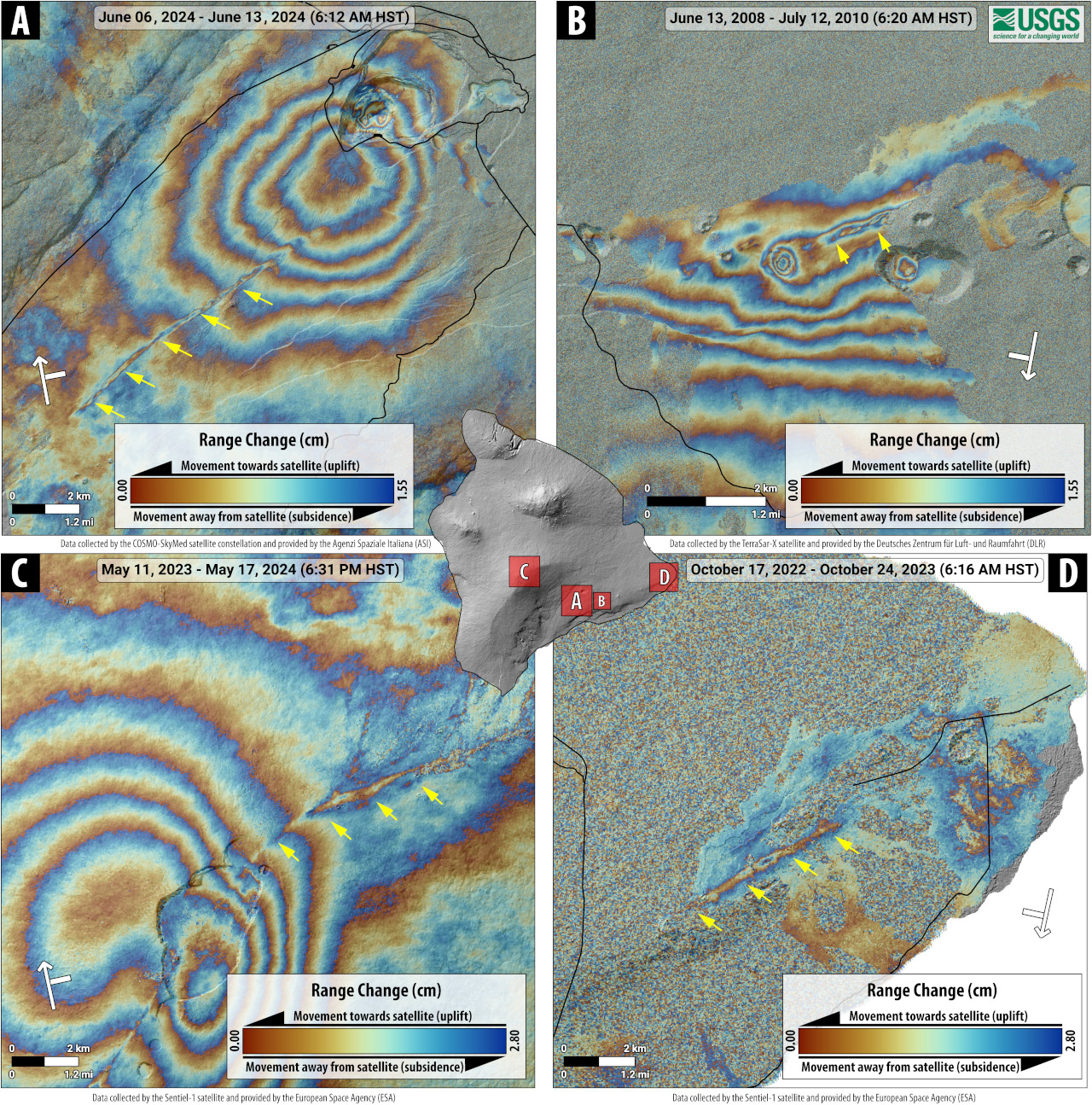
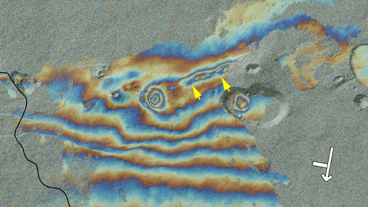
Radar interferograms showing examples of linear subsidence features (indicated by yellow arrows) that occurred directly above recent dike intrusions. (A) COSMO-SkyMed interferogram spanning June 6–13, 2024, showing inflation of Kīlauea’s summit area, but also a narrow and linear zone of subsidence about the Southwest Rift Zone caused by cooling of the dike that feed an eruption on June 3, 2024. (B) TerraSAR-X interferogram spanning June 13, 2008–July 12, 2010, showing complex deformation on Kīlauea’s East Rift Zone near Maunaulu and Makaopuhi Crater. The deformation includes overall contraction of the rift zone, subsidence of former pit craters that were filled by lava in the 1960s (these appear as “bullseyes” of colored fringes), and a linear zone of subsidence above the “Fathers Day” dike, which intruded during June 17–19, 2007, and fed a small eruption on the north side of Kānenuiohamo. (C) Sentinel-1 interferogram of the summit region of Mauna Loa spanning May 11, 2023–May 17, 2024, showing overall inflation following the volcano’s 2022 eruption, as well as a narrow, linear zone of subsidence along the Northeast Rift Zone caused by cooling and contraction of the dike intrusion that fed the eruption. (D) Sentinel-1 interferogram of Kīlauea’s lower East Rift Zone spanning October 17, 2022 – October 24, 2023, showing a narrow and linear zone of subsidence above the dike intrusion that fed the 2018 eruption. In all images, the white arrow shows the path of the satellite, with the perpendicular white bar giving the look direction.
Hawaiian volcanoes are rightly famous for eruptions along their rift zones—geologic structures that are undergoing extension and through which magma can move over great distances. Kīlauea and Mauna Loa each have two major rift zones that radiate away from the volcano summits, and rift zone eruptions are common. Mauna Loa’s 2022 eruption, and Kīlauea’s 1983–2018 Puʻuʻōʻo eruption and the 2018 Ahuʻailāʻau eruption, all occurred from rift zones.
Magma moves through Hawaiian rift zones as dikes, which are a tabular sheets of magma that move laterally and vertically beneath the ground. When a dike reaches the surface, it often erupts as a linear curtain of lava, as several recent eruptions on the Island of Hawaiʻi have demonstrated.
As dikes form in a rift zone, they wedge the zone apart, creating lots of surface displacement. Sometimes, the amount of horizontal and vertical deformation that occurs in the vicinity of a dike intrusion can exceed several feet (about a meter).
Once the dike stalls and any eruption (if one occurred) ends, one might think that is the end of the story. Not so. The signs of magma beneath the surface can be detected for years thereafter.
One rather obvious sign of recently active magma below the ground is thermal energy. Especially where a dike reached shallow levels, the ground will remain hot. Vapor emissions are common in those areas because rainwater that circulates below ground is warmed by the still-hot rock and rises to the surface as steam.
The ground can also continue to deform long after the dike activity has ended. As magma cools, it solidifies from its molten state and continues to drop in temperature as solid rock. During this process, it contracts or shrinks, like most materials (except water). Because magma underground cools very slowly (it is very well insulated down there!), it can take years to decades, and perhaps even centuries, before reaching background temperatures. Thermal contraction is fastest during the initial, most rapid phases of cooling, and that is reflected in the way the surface responds.
As the magma cools and contracts, the ground above the shallow parts of a dike subsides (sinks). This deformation is especially easy to see by comparing satellite radar images over time—a technique known as interferometric synthetic aperture radar, or InSAR. The subsidence looks like a linear streak that occurs directly above the dike in InSAR data. In that sense, using InSAR to map subsidence after a dike intrusion can help geologists understand where exactly a dike is located, how much magma is in the dike, and how quickly it is cooling.
The linear pattern of subsidence seen in InSAR images is apparent after nearly all dike intrusions at Hawaiian volcanoes. For example, subsidence occurred for a few years above the so-called “Fathers Day” dike that intruded between Maunaulu and Makaopuhi Crater in June 2007, feeding a very small eruption on Kānenuiohamo. Subsidence also marks the lower East Rift Zone of Kīlauea above the trace of the dike that erupted in 2018. Streaks of subsidence are likewise apparent above the dikes that erupted from Mauna Loa’s Northeast Rift Zone in 2022 and from Kīlauea’s Southwest Rift Zone in 2024.
There is obviously a lot to measure when magma moves through the rift zones of Hawaiian volcanoes, and it is a time of special vigilance, given how many residents live on the flanks of our active volcanoes. But the action doesn’t stop just because the eruption or intrusion ends. There’s still much that can be learned about the characteristics of magma within Hawaiian rift zones from mapping deformation patterns after the magma has stopped moving!

by Big Island Video News
on at
STORY SUMMARY
HAWAIʻI ISLAND - Whether or not an intrusion results in an eruption, subsurface magma has a noticeable impact on the landscape.