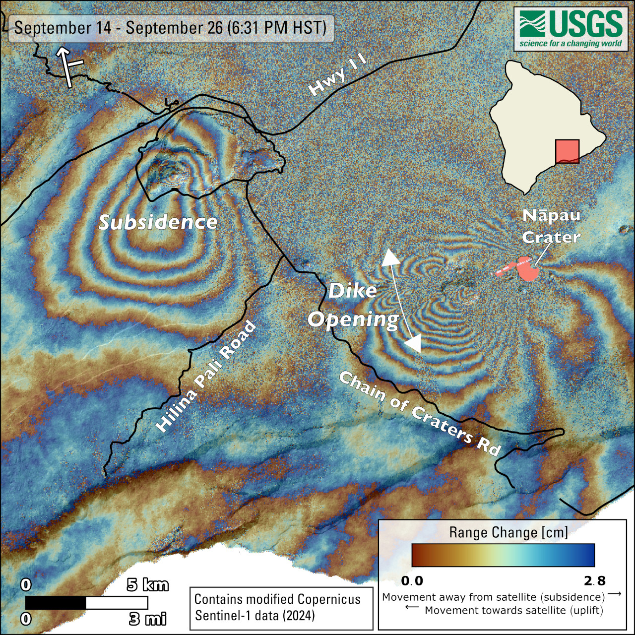
USGS: “This map shows recent deformation at Kīlauea over the timeframe of September 14–26, 2024, during which an eruption occurred on the East Rift Zone. Data were acquired by the European Space Agency’s Sentinel-1A satellite. Colored fringes denote areas of ground deformation, with more fringes indicating more deformation. Each color cycle represents 2.8 cm (1.1 in) of ground motion. The symbol in the upper left indicates the satellite’s orbit direction (arrow) and look direction (bar) and north is up on the figure. The bulls-eye feature southwest of Kaluapele (Kīlauea summit caldera) indicates ground subsidence over this time period as magma moved from summit storage regions and intruded underground into the area west of Nāpau Crater on the East Rift Zone. The butterfly-shaped feature west of Nāpau Crater indicates ground surface extension over this time period as the magma intruded, resulting in the eruption in and west of Nāpau Crater from September 15–20, 2024. Lava flows from this eruption, which covered 156 acres with new rock in and near Nāpau Crater, are shown in pink and the eruptive fissures are shown in light purple.”
(BIVN) – Kīlauea is not erupting and the USGS Volcano Alert Level has remains at ADVISORY.
“Only a few intermittent small spots of residual glow could be detected on the flow field last night” in the area of Nāpau Crater, scientists reported on Sunday morning. They added that weak steaming at the vents continues.
“Geophysical signatures of eruptive activity have all returned to background levels,” the USGS Hawaiian Volcano Observatory reported.
Nāpau Trail and Nāulu Trail remain closed within Hawaiʻi Volcanoes National Park.
From the USGS HVO on Sunday morning:
Summit Observations: Four earthquakes were detected beneath the Kīlauea summit region over the past 24 hours. The summit tiltmeters at Uēkahuna and Sandhill show indications of slight inflation over the past day. The most recent measurement of SO2 emission rate at the summit was 60 tonnes per day on September 17, 2024.
Rift Zone Observations: The middle East Rift Zone (MERZ) eruption near Nāpau Crater has ended. The last eruptive activity stopped around 10 AM HST on the morning of September 20. Only minor intermittent glow can be seen from the eruption site at night since that time. No SO2 from the eruption site was detected on Monday, September 23rd, during measurements on Chain of Craters Road, indicating that MERZ SO2 emissions are approaching or at 0 tonnes per day.
Shallow earthquake counts remain very low in the MERZ and upper East Rift Zone and tremor is no longer being recorded on seismometers close to the eruption site. Tiltmeters in the MERZ continue to show no significant shallow deformation and GPS instruments show a major decrease or cessation of inflation at deeper levels beneath the area between Maunaulu and Nāpau Crater.
All recent activity was confined to the middle East Rift Zone between Makaopuhi Crater and Puʻuʻōʻō and there are no indications of any changes further downrift in the MERZ or in the LERZ.

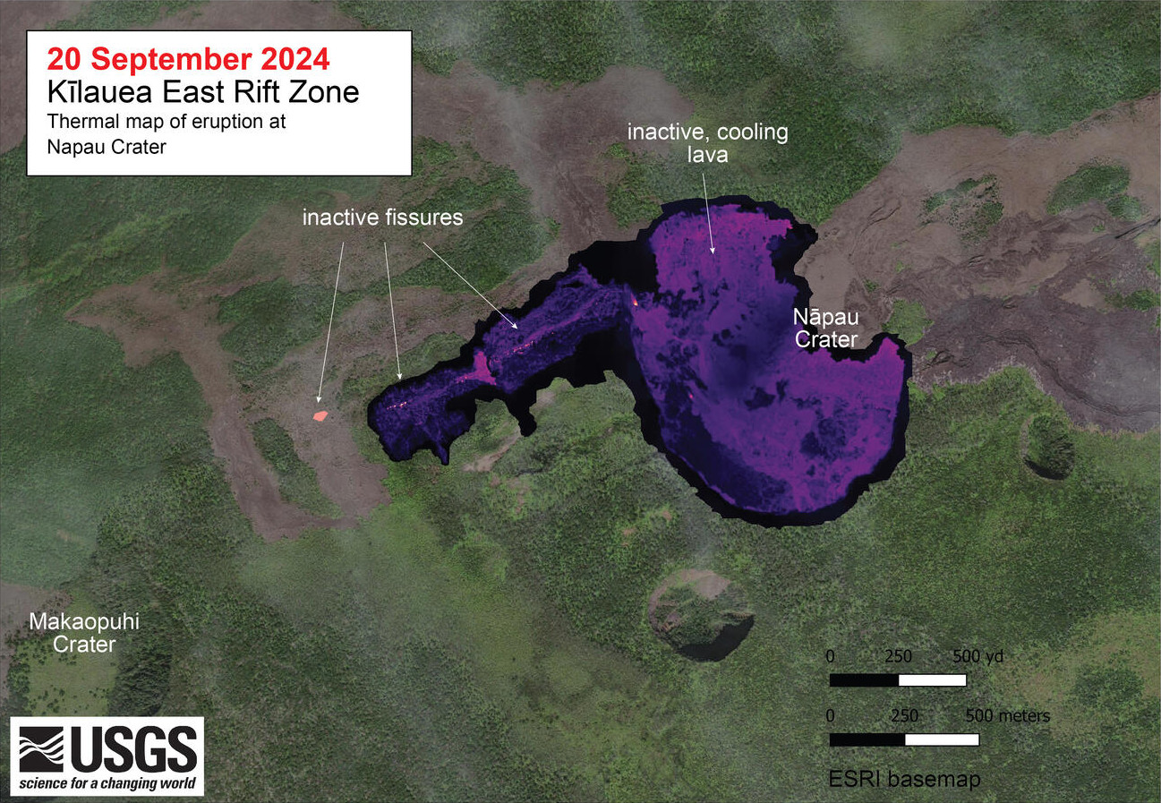
USGS: “A helicopter overflight on September 20, 2024, allowed for aerial visual and thermal imagery to be collected at the middle East Rift Zone eruption site on Kīlauea. This thermal map shows that the eruption at Nāpau Crater had paused this morning, with no fountaining or active lava on the surface. Shortly after these morning thermal images were collected, a small portion of the fissure system briefly reactivated, but soon died out again. As of this afternoon, the eruption was again in a pause. The scale of the thermal map ranges from blue to red, with blue colors indicative of cooler temperatures and red colors indicative of warmer temperatures.”
Analysis: The eruption in and near Nāpau Crater had four eruptive phases between September 15 and September 20. The final eruptive activity from a small vent west of Nāpau Crater ended at about 10 AM HST on September 20. All observable and instrumental signs of potential for renewed eruptive activity have declined since that time. Seismicity in the area is extremely low and tremor, characteristic of magma within vents, is no longer being recorded by seismometers in the area. In addition, the ground deformation data that showed magma was moving from the summit to the middle East Rift Zone has slowed dramatically or stopped altogether. Volcanic gas emissions have decreased to background levels. All of these factors indicate that this eruption has ended.
Lava flows from this eruption covered about 2/3 (500,000 square meters or 125 acres) of the floor of Nāpau Crater. In total, this eruption has covered more than 630,000 square meters (156 acres) of Nāpau Crater and areas to the west since Sunday night. Approximate effusion rates of roughly 5-15 cubic meters per second (6-16 cubic yards) were estimated during the most active part of the fissure eruption on September 19.


by Big Island Video News10:06 am
on at
STORY SUMMARY
HAWAIʻI VOLCANOES NATIONAL PARK - Scientists say geophysical signatures of eruptive activity at Kīlauea have all returned to background levels.