(BIVN) – The USGS Hawaiian Volcano Observatory raised the Volcano Alert Level for Kīlauea from ADVISORY to WATCH early Monday morning. Despite some data signals indicative of eruptive activity, scientists have not seen visual evidence of an eruption at this time.
The raise in the Kīlauea Alert Level is in connection with the intrusion of magma in the middle East Rift Zone that began Saturday, September 14th.
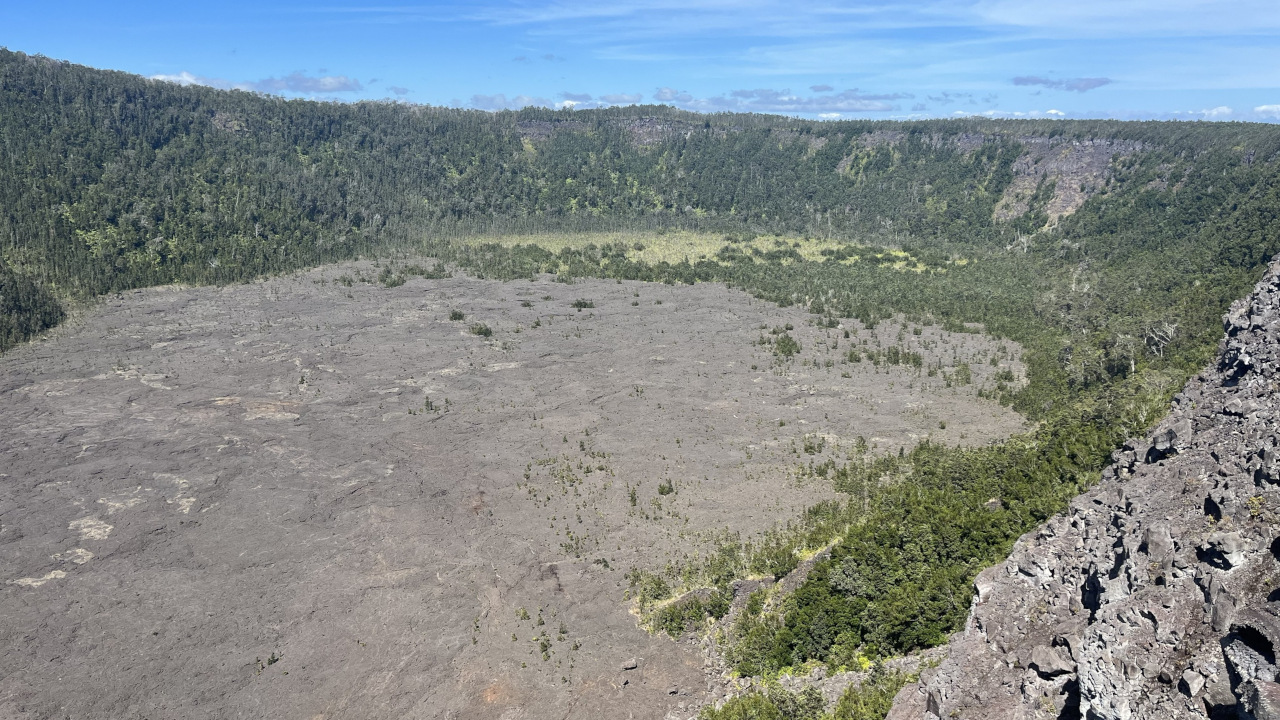
Earthquakes and ground deformation are concentrated between Maunaulu and Makaopuhi Crater, within Hawaiʻi Volcanoes National Park. No changes have been detected in the lower East Rift Zone, or Southwest Rift Zone.
Along with the USGS Volcano Alert Level change, the Aviation Color Code was also raised from YELLOW to ORANGE.
Hawaiʻi Volcanoes National Park has closed Chain of Craters Road “due to heightened gas emissions and seismic activity.”
From the USGS Volcanic Activity Notice issued at 12:23 a.m. Monday morning:
The intrusion of magma that began yesterday, September 14, in Kīlauea’s middle East Rift Zone, continues, increasing the potential of an eruption in this region. Accordingly, the USGS Hawaiian Volcano Observatory (HVO) is raising the Volcano Alert Level for ground-based hazards from ADVISORY to WATCH and the Aviation Color Code from YELLOW to ORANGE.
Current activity is taking place in a remote area of Kīlauea’s middle East Rift Zone, within Hawaiʻi Volcanoes National Park. No changes have been detected in the lower East Rift Zone, or Southwest Rift Zone.
Intense and localized earthquakes between Maunaulu and Makaopuhi Crater, accompanied by ground deformation patterns indicative of underground crack growth began at approximately 6 p.m. HST on September 14, 2024. While the intensity of earthquake activity has decreased, continued ground deformation changes show that magma is still moving beneath the ground from summit storage chambers to the area between Maunaulu and Makaopuhi Crater. An InSAR image showing recent ground extension between Maunaulu and Makaopuhi Crater is available here:
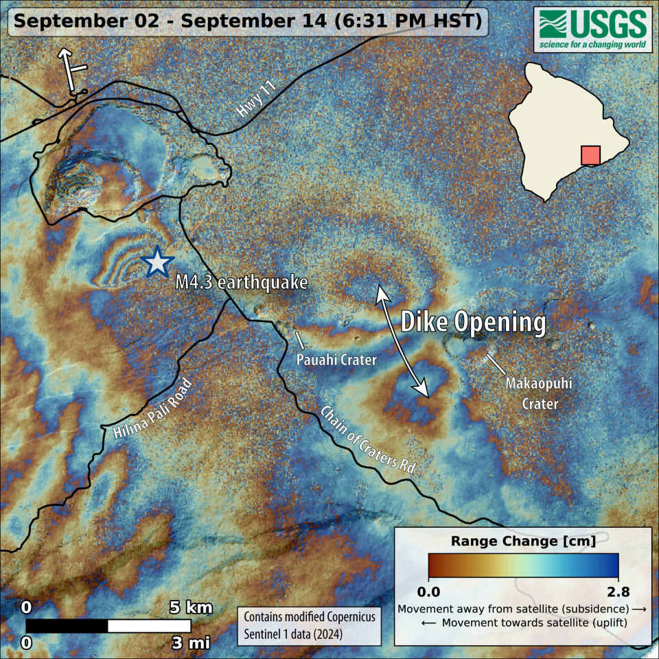
This map shows recent deformation at Kīlauea over the timeframe of September 2–14, 2024. Data were acquired by the European Space Agency’s Sentinel-1A satellite. Colored fringes denote areas of ground deformation, with more fringes indicating more deformation. Each color cycle represents 2.8 cm (1.1 in) of ground motion. The symbol in the upper left indicates the satellite’s orbit direction (arrow) and look direction (bar). The butterfly-shaped feature between Pauahi and Makaopuhi Craters on the middle East Rift Zone indicates ground surface extension over this time period as magma intruded underground. Increased earthquake activity associated with the intrusion of magma began around 4 p.m. HST on September 14 and is ongoing as of the afternoon of September 15, though it has decreased in intensity. The largest earthquake during the magmatic intrusion, a magnitude-4.3 in the south part of Kaluapele (the caldera), was associated with slip along one of the outer caldera faults—a consequence of stress changes due to the intrusion.
Starting around 9 p.m. and continuing until 10 p.m. HST this evening, infrasound instruments detected a strong signal typical of gas or steam venting and seismometers in the middle East Rift Zone are recording weak, sustained low frequency tremor. However, HVO’s webcam network has not shown any evidence of eruptive activity and GOES satellite data do not show any thermal anomalies at this time. Currently, strong rainfall in the area is complicating interpretation. In 2007, an intrusion in this area erupted a very small pad of lava approximately the size of half a football field, so it is possible a similarly small eruption could take place without detection in these conditions.
Numerous eruptions took place in this area during the 1960s–1970s, most of which lasted less than one day to about two weeks. Long-lived eruptions took place at Maunaulu (1969–1971 and 1972–1974) and Puʻuʻōʻō (1983–2018). The most recent eruption in this area took place over 35 years at and near the Puʻuʻōʻō vent. The location of any future outbreak will determine what areas could be in the path of new lava flows. A map of past eruptive activity in the upper-to-middle East Rift Zone of Kīlauea is available here:
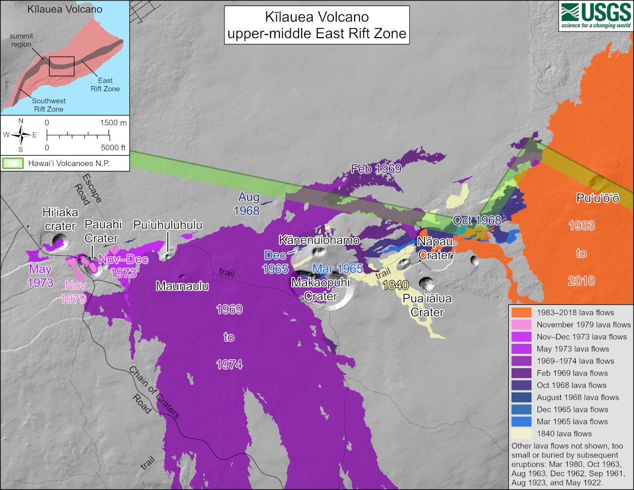
USGS: “This reference map depicts the features on Kīlauea’s middle East Rift Zone, much of which is within Hawaiʻi Volcanoes National Park. Pit craters and lava flows are evidence of a long history of magma moving along this rift zone pathway. Numerous eruptions took place in this region during the 1960s–1970s. Most eruptions in this area during that timeframe lasted less than one day to about two weeks, though there were long-lived eruptions at Maunaulu (1969–1971 and 1972–1974) and Puʻuʻōʻō (1983–2018). The most recent eruption in this area took place over 35 years at and near the Puʻuʻōʻō vent (shown in orange on the map).”
HVO is in close contact with Hawai‘i Volcanoes National Park and the Hawai‘i County Civil Defense Agency. Please see the Hawaiʻi Volcanoes National Park website for visitor information.
HVO will continue to monitor this activity closely and adjust the alert level/aviation color code for Kīlauea accordingly. Should volcanic activity change significantly, a new Volcanic Activity Notice will be issued. Hazards are present on Kīlauea and are described below.

by Big Island Video News
on at
STORY SUMMARY
ISLAND OF HAWAIʻI - Despite an infrasound signal typical of gas or steam venting, and seismometers recording low frequency tremor, visual evidence of eruptive activity has yet to be seen.