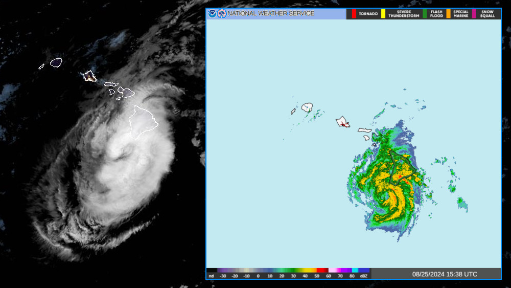
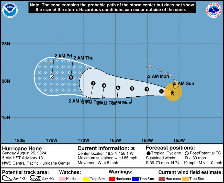
(BIVN) – Hurricane Hone was 50 miles south-southwest of South Point on Hawaiʻi island as of 5 a.m. on Sunday morning, battering Big Island with high winds and heavy rain.
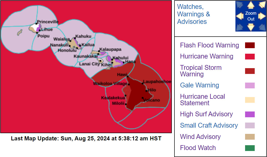
The storm has strengthened slightly overnight. Hurricane Hone is now generating maximum sustained winds of 85 mph with higher gusts. Nearly the entire island of Hawaiʻi is under a Flash Flood Warning.
Hurricane-force winds extend outward up to 25 miles from the center of Hone, and tropical-storm-force winds extend outward up to 115 miles, the Central Pacific Hurricane Center says. A Tropical Storm Warning remains in effect for the entire island of Hawaiʻi.
According to Hawaiian Electric, nearly 12,000 customers are without power on the Big Island.
Highway 11 – between Whittington Beach and Punaluʻu Beach – is closed due to flooding. No alternate routes are available, police say. The east end of Wood Valley Road is also closed due to flooding.
Officials say Kaloli Drive and Huina Road, both in Puna, are closed due to downed trees.
Hawaiʻi County Parks and Recreation has closed the Hilo Municipal Golf Course due to flooding and debris.
The Hawaiʻi County Department of Environmental Management has closed the Oceanview and Pahala transfer stations.
“Deep tropical moisture associated with Hone continues to move into windward portions of the Big Island and is currently producing near inch to an inch and half per hour rates within the strongest rain bands,” the National Weather Service reported. “Based upon surface observations and radar estimates, the windward areas of the Big Island have already picked up 4 to 8 inches (with locally 10 plus inches) of rain from Hone over the past 24 hours. Moderate to heavy precipitation is expected to impact the Hilo, Puna and Kaʻu regions of Big Island through at least early Monday.”
Forecasters say “strong and gusty winds associated with the storm will continue to impact Big Island, with widespread gusts of 50 to 60 mph through the local exposed valleys and higher elevations (e.g., Kohala Ranch, Humuʻula Saddle, Upolu Point, Waikoloa) through this afternoon.” Localized gusts could reach 70 mph.
From the Central Pacific Hurricane Center at 5 a.m. HST:
Hone is passing by around 40 nautical miles south of South Point on the Big Island of Hawaii this morning, where it is within radar range. Combined radar, and data from an Air Force Reserve reconnaissance aircraft mission earlier this morning, support raising the initial intensity of Hone to 75 knots, keeping it a Category 1 Hurricane. Despite recent subjective Dvorak estimates suggesting a slightly lower intensity, the satellite presentation has evolved markedly overnight, with cold cloud tops near -75 C reinforcing the radar and aircraft-based intensities. The initial intensity is raised to 75 kt for this advisory.
The initial motion of Hone is set at 280/07. This westward trajectory is expected to persist over the coming days, influenced by a subtropical ridge to the north. However, as Hone remains near the Big Island through the early morning hours today, the mountainous terrain could influence local steering currents, potentially leading to localized and short-term deviations in the storm’s motion and intensity. As we move into the early to mid portion of the week, Hone is projected to encounter increasing vertical wind shear, which is expected to weaken the storm and make it more shallow. This change in conditions will allow the low-level trade wind flow to steer the system toward the west-southwest. The official forecast track remains nearly identical to the previous advisory and is closely aligned with the tightly clustered consensus guidance.
Environmental conditions affecting Hone will remain steady over the next 12 to 24 h, with sea surface temperatures between 26 C and 27 C, light to moderate vertical wind shear, and sufficient mid-level moisture. This supports maintaining a steady trend in intensity through the morning hours today. Although sea surface temperatures are forecast to rise to around 27 C tonight and beyond as Hone continues westward, increasing vertical wind shear will translate to a gradual weakening trend later today through the middle of the week. The intensity forecast closely follows dynamical consensus guidance.
KEY MESSAGES:
1. Tropical Storm conditions will continue on the Big Island through the morning hours. Winds are expected to be strongest downslope of higher terrain, over headlands, and through passes.
2. Hone is expected to produce storm total rainfall of 6 to 12 inches over mainly windward and southeast facing slopes of the Big Island, with locally higher amounts possible. Rainfall totals of 2 to 4 inches will be possible over portions of the smaller islands, mainly windward.
3. Swells generated by Hone will continue today as this system continues westward. Expect dangerous conditions with life-threatening surf and rip currents.


by Big Island Video News6:00 am
on at
STORY SUMMARY
HAWAIʻI ISLAND - Nearly the entire island of Hawaiʻi is under a Flash Flood Warning, as Hurricane Hone clips the Big Island to the south.