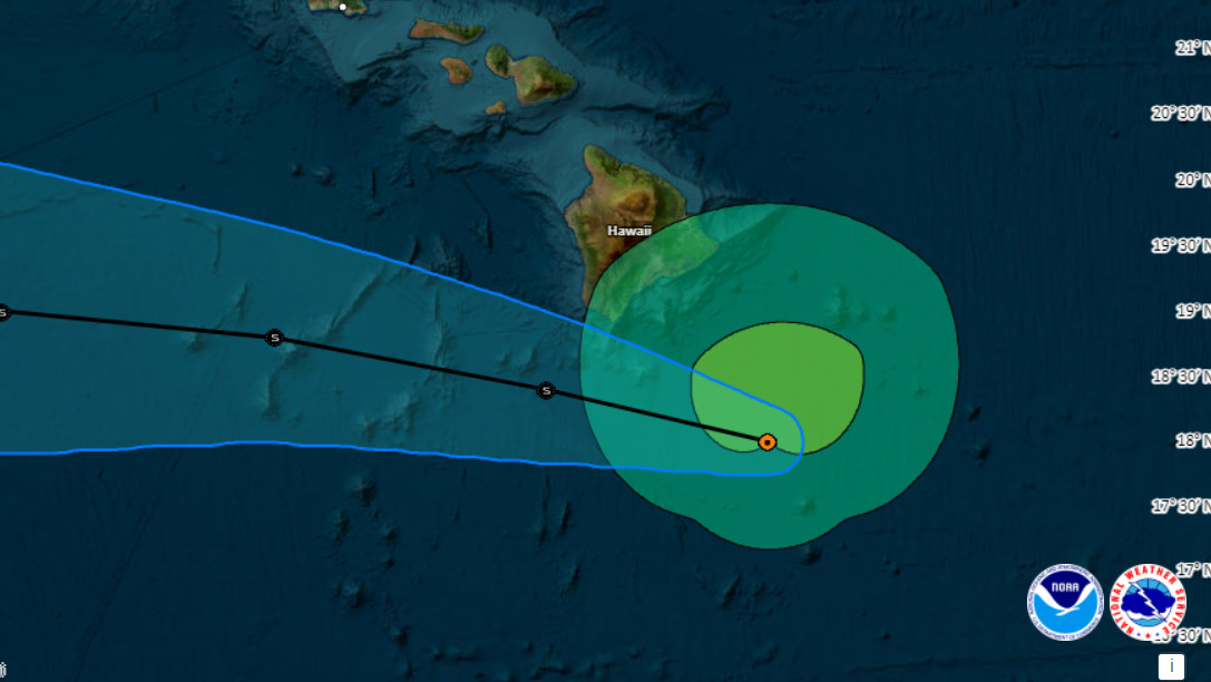
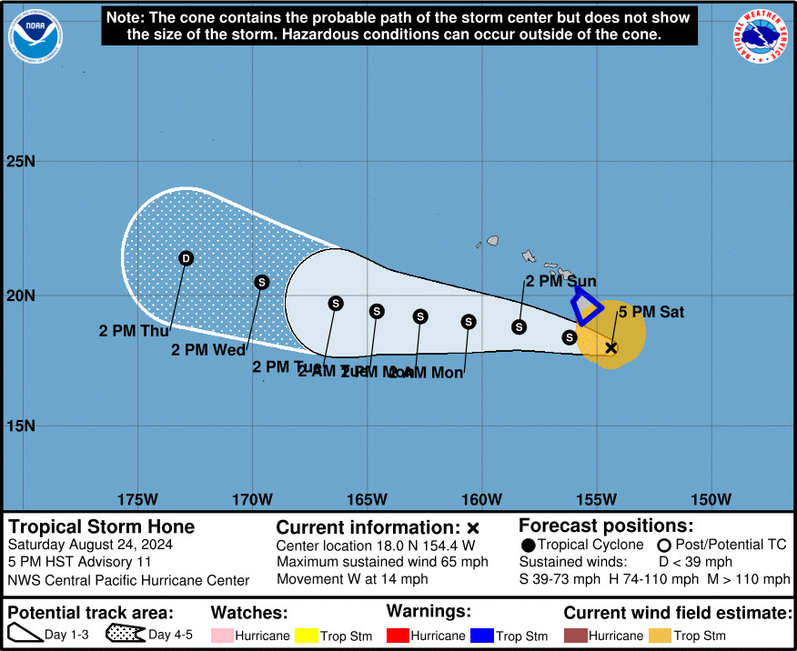
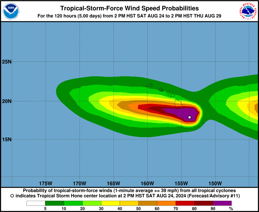
(BIVN) – Tropical Storm Hone was 125 miles south-southeast of Hawaiʻi island as of 5 p.m. Saturday evening, moving west at 14 mph. With tropical-storm-force winds extending outward up to 125 miles from the center of the storm, the effects of Hone are now starting to be felt on the windward side of the Big Island.
A Tropical Storm Warning remains in effect for Hawaiʻi County, and a Flood Advisory has been issued for various locations.
“At 5:25 p.m. HST, 2 to 4 inches of rain has fallen over windward Big Island today, and radar indicated continued moderate to locally heavy showers moving ashore with rates of a half to one and a half inches per hour,” the National Weather Service in Honolulu wrote. “Streams continue to slowly rise along windward Big Island. Rainfall is expected to persist through tonight as Tropical Storm Hone passes just south of the Big Island.”
Forecasters say Hone is expected to produce rainfall amounts of 6 to 12 inches over mainly windward and southeast facing slopes of the Big Island, with locally higher amounts possible.
A High Surf Warning is also in effect for east-facing shores.
“Based on the current forecast track, strong and gusty winds associated with Hone will continue to impact the Big Island, with widespread gusts up to 50 mph likely through early Sunday,” the National Weather Service said. “The strongest gusts are expected around South Point/Ka Lae, as well as downslope from Mauna Kea, Mauna Loa, the Kohala Mountains, and the Humuula Saddle, which could see localized gusts as high as 60 mph.”
Earlier today, a Hawaiʻi County Civil Defense message announced the opening of multiple shelters on the Big Island. It also stated that all County beach parks are closed until further notice.
The Hawaiʻi Department of Transportation also posted a travel advisory for Hilo International Airport, explaining that the terminal is open, “however, there are no further flights out of ITO tonight.”
From the 5 p.m. discussion by the Central Pacific Hurricane Center:
After briefly becoming exposed, the low level circulation center of Hone has become obscured by deep convection once again late this afternoon. Overall organization remains steady, while motion has slowed a bit and deviated very slightly right of track over the past six hours. Latest data from U.S. Air Force Reserve Hurricane Hunter aircraft showed maximum sustained winds of 51 knots, reduced from flight level. This is slightly higher than subjective Dvorak satellite derived intensities of 45 kt from CPHC and JTWC. Reconnaissance values take precedence and the initial intensity for Hone will be maintained at 55 kt. Initial pressure will remain 1000 mb.
The initial motion is set at 280/12, slightly slower than the last two forecast cycles. A bit north of due west, this general motion is expected to continue over the next several days under the influence of a subtropical ridge to the north. Some forward motion slowing is anticipated as the ridge weakens slightly. Hone is expected to pass near or just south of the Big Island of Hawaii this evening through early Sunday, where a Tropical Storm Warning remains in effect. By the middle of the coming week, Hone will likely become increasingly shallow as vertical wind shear increases, allowing the low-level trade wind flow to steer the system toward the west-southwest. The official forecast track is nearly identical to the previous advisory, and closely follows the tightly clustered consensus guidance.
Expect sea surface temperatures between 26C and 27C, light to moderate vertical wind shear, and marginally sufficient mid-level moisture along Hone’s path. Slow strengthening will continue into Sunday tonight. While sea surface temperatures are forecast to rise to around 27C beyond 24 hours, guidance continues to present a rather compelling case for capping Hone intensity at 60 kt Sunday and Monday, just below hurricane strength. As Hone continues westward, increasing vertical wind shear may weaken it later Monday through the middle of next week. The intensity forecast closely follows dynamical consensus guidance.
KEY MESSAGES:
1. The potential for excessive rainfall and flash flooding on portions of the Big Island of Hawaii persists through Sunday as a large area of moisture associated with Hone moves through. The heaviest rainfall will likely occur over windward and southeast facing slopes.
2. Tropical Storm conditions are expected on the Big Island beginning this evening and continuing through early Sunday. Winds are expected to be strongest downslope of higher terrain, over headlands, and through passes.
3. Swells generated by Hone will continue through Sunday as this system continues westward. Expect dangerous conditions with life-threatening surf and rip currents.


by Big Island Video News6:09 pm
on at
STORY SUMMARY
HAWAIʻI ISLAND - A Tropical Storm Warning remains in effect for the entire Big Island, with strong winds and rainfall totals of 6 to 12 inches expected.