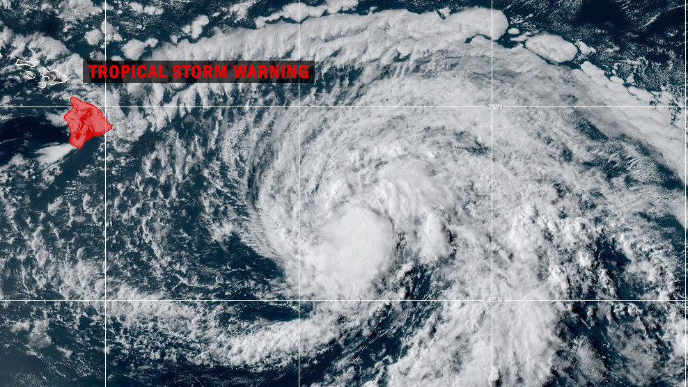
(BIVN) – A Tropical Storm Warning has been issued for Hawaiʻi island, as Tropical Storm Hone continues churning in the Central Pacific.
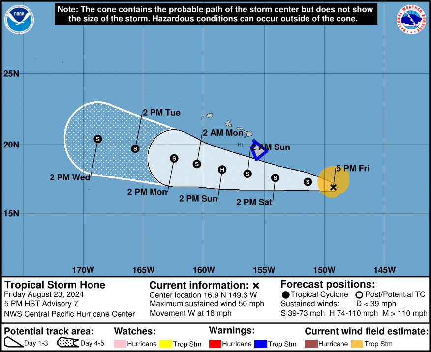
As of 5 p.m. on Friday evening, Tropical Storm Hone was 425 miles east southeast of Hilo, moving west at 16 mph.
On the forecast track, the center of Hone is expected to pass near or south of the Big Island on Saturday evening into early Sunday.
Tropical Storm Hone’s maximum sustained winds are near 50 mph (85 km/h) with higher gusts. The Central Pacific Hurricane Center says the storm is forecast to strengthen over the next 48 hours, and may become a hurricane by Sunday.
From the National Weather Service in Honolulu:
Winds associated with Hone will increase over the Big Island on Saturday and may become locally damaging by nightfall. Tropical storm conditions, with sustained winds over 39 mph, are possible Saturday night into Sunday. Winds will be the strongest where they blow downslope from higher terrain, over headlands, and through passes. This includes areas like the Humuula Saddle, the Waimea Saddle, leeward Kohala, and South Point.
Persistent rainbands on the north side of Hone may bring excessive rainfall and flash flooding to portions of the Big Island starting Saturday afternoon and continuing through the remainder of the weekend. The Hamakua, Hilo, and Kau Districts appear to have the highest risk for flash flooding. A few lingering heavy thundershowers may persist over portions of the Big Island into Monday, especially over leeward and upslope areas.
Forecasters say preparations for Tropical Storm Hone should be completed by midday Saturday.
Hawaiian Electric says it has activated its emergency response plan, and is making preparations to quickly respond to customer outages and other impacts to our systems.
Hawaiʻi County camping permits have been cancelled this weekend for Punuluʻu Beach Park and Whittington Beach Park.
Closures were also announced by the Hawaiʻi Department of Land and Natural Resources. The DLNR’s Division of Forestry and Wildlife is closing camping areas and rescheduling special hunts this weekend.
ʻĀinapō cabin, Keanakolu cabin, and Waimanu campsites will be closed, the DLNR says. Notifications have been sent to all campers who requested permits.
The Youth and Disabled Hunt and the Makai Archery Hunt at Puʻu Waʻawaʻa Forest Reserve will also be closed. The hunt is anticipated to resume on August 31.
The Hawaiʻi Tourism Authority also sent out a news release, urging visitors to remain vigilant at the storm nears.
“It is still safe to travel to the Hawaiian Islands at this time,” the HTA said. “We are not advising visitors to cancel their trips.”
From the Central Pacific Hurricane Center discussion posted at 5 p.m. HST:
The U.S. Air Force Reserve Hurricane Hunter aircraft sampled Tropical Storm Hone from this morning into early afternoon and provided valuable data. In spite of its lack of convection, Hone maintained a well-developed low cloud field and remained surprisingly intense through the morning, well above Dvorak inputs from the fix agencies. Late this afternoon, deep convection is redeveloping near the center as winds aloft ease. The latest data from the Hurricane Hunters came in just before 00Z and showed maximum sustained winds holding at 45 kt and a minimum sea level pressure of 1000 mb. Given the appearance of Hone, these values will be used for the initial intensity.
The initial motion is unchanged at 280/14. This general motion toward slightly north of due west will continue during the next several days as Hone is steered by a deep subtropical ridge to the north. However, some slowing of the forward motion is anticipated as the deep ridge to the north of Hone weakens slightly. Along this track, Hone will be passing near or just south of the state late Saturday into early Sunday, which necessitates the issuance of a Tropical Storm Warning for the Big Island of Hawaii. By the middle of next week, Hone will likely become increasingly shallow as vertical wind shear increases, allowing the low level trade wind flow to steer the system toward the west. The official forecast track is nearly identical to the previous advisory, and closely follows the tightly clustered consensus guidance near the TVCN.
Hone has a window for intensification during the next 36 to 48 hours. Easterly winds aloft, which have inhibited outflow in all but the south and southwest quadrants, will relax tonight and Saturday as a weakness develops in the upper level ridge north of the cyclone. Sea surface temperatures will remain around 26-27C, which will be sufficient for intensification, possibly to hurricane strength, late Saturday or early Sunday. Late Sunday and Monday, west to northwest vertical wind shear will increase sharply, which should result in steady weakening. The intensity forecast remains on the higher side of the guidance envelope near the HCCA and slightly higher than the IVCN. Beyond 48 hours, the forecast closely follows the IVCN.


by Big Island Video News5:12 pm
on at
STORY SUMMARY
HAWAIʻI - Tropical Storm Hone is 425 miles east southeast of Hilo, and will bring the potential for excessive rainfall and flash flooding to portions of the Big Island starting later Saturday.