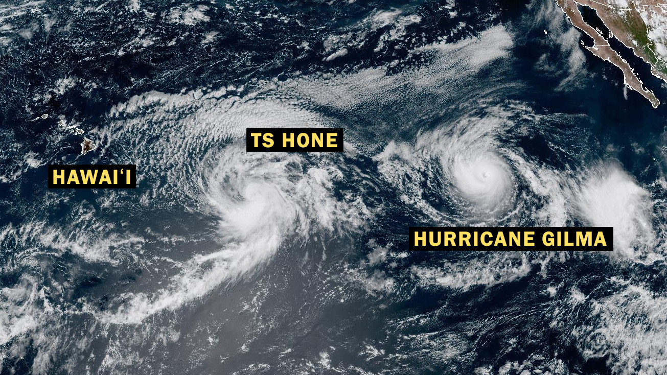
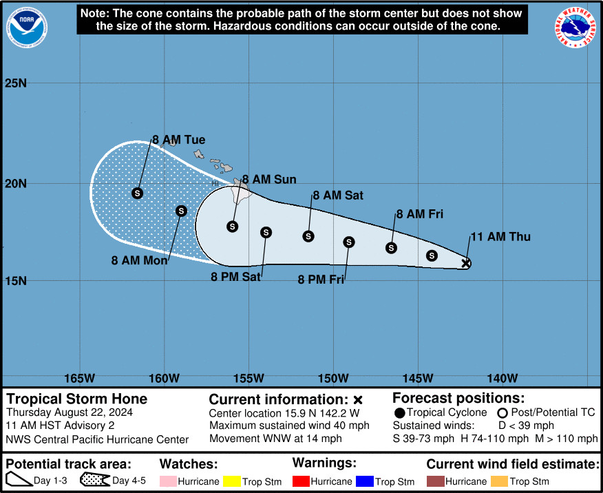
(BIVN) – Tropical Depression One-C has become Tropical Storm Hone. The storm is in the Central Pacific, about 885 miles east southeast of Hilo as of 11 a.m. HST.
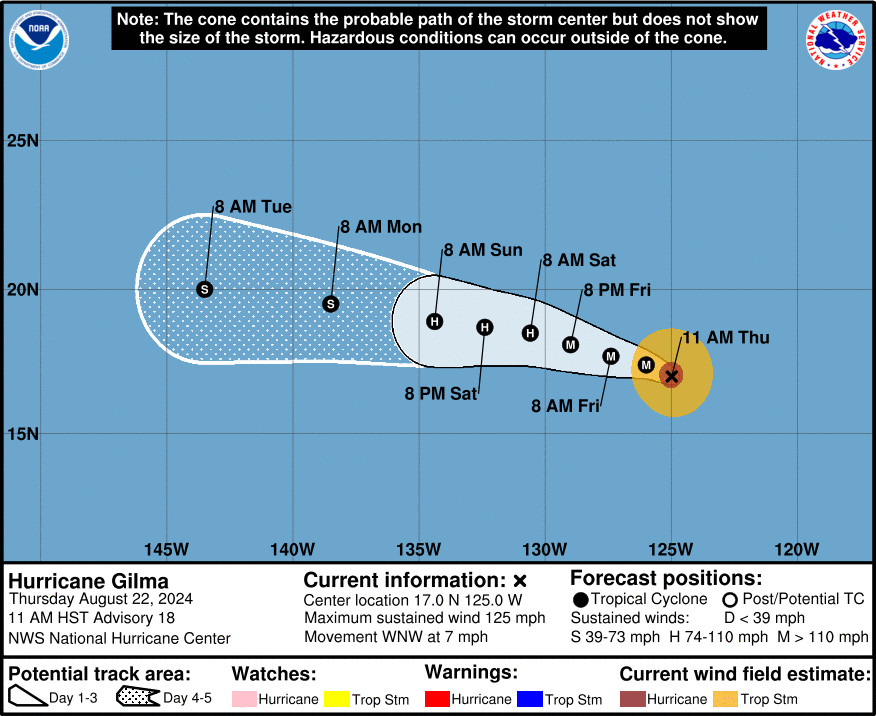
Behind TS Hone is Hurricane Gilma, a major hurricane located in the Eastern Pacific, about 1,980 miles east of Hilo.
Officials are advising residents of Hawaiʻi to monitor the progress of the closer Tropical Storm Hone, as it moves to the west-northwest near 14 mph. On the
forecast track, the center of Hone is expected to pass near or south of the Big Island this weekend.
According to the Central Pacific Hurricane Center discussion posted at 11 a.m. HST on Thursday:
Hone is expected to remain in an environment of low to moderate vertical wind shear, warm sea surface temperatures between 27 and28C, and in a sufficient area of deep layer moisture over the next several days. This should support gradual strengthening as the system moves in a steady westward direction. Late in the weekend into early next week, the system will begin to encounter an increase in westerly vertical wind shear, and possibly some drier mid-level air. This should lead to the gradual weakening of the system. The intensity forecast is close to the intensity consensus during the next several days, bringing the system up close to hurricane strength over the weekend, with the forecast lower than the consensus guidance by days 4 and 5.
The National Weather Service in Honolulu at 11 a.m. HST detailed the potential impacts that Tropical Storm Hone could bring to the islands:
On the current forecast track for Hone, winds will strengthen through the weekend across the state with widespread gusts to 40 mph possible Saturday, and up to 50 mph on Sunday, as the pressure gradient increases. The strongest gusts given this storm track would typically be expected around South Point/Ka Lae, as well as downslope from Mauna Kea, Mauna Loa, the Kohala Mountains, and the Humuula Saddle.
Drier air is expected to move across the western end of the state ahead of the tropical system on Saturday, so it should be a dry and windy day for those areas. Then increased moisture will move in from the east sometime late Saturday into Sunday, increasing the potential for heavy rainfall across windward and southeast areas of the Big Island. Then heavy shower coverage may expand northward to cover more of the state by Sunday. Given the potential for prolonged heavy rainfall, localized flash flooding could occur if the rain becomes concentrated.
If Hone follows more closely to the right side of the forecast track cone from CPHC, there would be greater impacts felt across portions of Hawaii…with an increased potential for damaging winds and flash flooding, mainly for the eastern end of the state.
Following behind Tropical Storm Hone is major Hurricane Gilma, with maximum sustained winds near 125 mph (205 km/h) and higher gusts.
There is a third weather system that could develop into a tropical cyclone in the next few days. This system is farther away from Hawaiʻi than Hurricane Gilma, and is several hundred miles to the south of the southern tip of the Baja California peninsula.
Forecasters say a Tropical Storm Watch may be required for portions of the main
Hawaiian Islands tonight or Friday.


by Big Island Video News1:25 pm
on at
STORY SUMMARY
HAWAIʻI - Tropical Storm Hone brings the potential for heavy rainfall, gusty winds, and dangerous surf and rip currents to Hawaiʻi.