(BIVN) – Kīlauea volcano is not erupting, but a third pulse of seismicity and local deformation on the upper East Rift Zone that began July 24th, continues.
The USGS Hawaiian Volcano Observatory issued another information statement on Wednesday evening, explaining that an eruption is not currently imminent, but conditions could change rapidly. The Volcano Alert Level remains at ADVISORY.
In their statement, scientists offered an interpretation of the data, saying that the recent earthquake swarms and deformation patterns “show that an intrusion of magma is occurring in the area of Pauahi Crater.” Magma is moving underground from the summit region towards the upper East Rift Zone, scientists believe.
Scientists also provided some possible scenarios that could play out in the coming weeks, including a growing intrusion, an eruption, or an intrusion that moves east into the middle East Rift Zone.
The USGS HVO provided this information:
An abrupt increase in seismicity accompanied by local deformation on July 22 at 11 a.m. HST marked the initial stage of magma intruding underground in the upper East Rift Zone (UERZ) of Kīlauea. This activity is concentrated between Pauahi Crater and Maunaulu along Chain of Craters Road in Hawaiʻi Volcanoes National Park.
A stronger pulse of seismicity and local deformation began on July 23 at 3:30 a.m. HST and was coincident with deflation of Kīlauea summit. The summit has been steadily deflating since then as magma moves into the vertical, sheet-like body (dike) beneath the UERZ near Pauahi Crater.
A third pulse of activity began today on July 24 at 10 a.m. HST as dike emplacement continues. Each pulse lasted approximately 2–3 hours, but seismicity and deformation continued at levels well above normal between the pulses.
In total, there have been nearly 1,000 earthquakes located in the UERZ of Kīlauea over the past 3 days; 250 of those earthquakes exceeded magnitude-2 and the largest event was a magnitude-3.6. Earthquakes have remained 1–3 km (0.6–1.8 miles) beneath the surface. As of 4:30 p.m. on July 24, the dike continues to grow, and unrest may continue to wax and wane with changes to the input of magma into the area. An eruption is not currently imminent, but conditions could change rapidly.
Unrest has been restricted to UERZ; no unusual activity has been noted along Kīlauea’s middle and lower East Rift Zones or the Southwest Rift Zone. The USGS Hawaiian Volcano Observatory (HVO) continues to closely monitor Kīlauea for changes.
INTERPRETATION
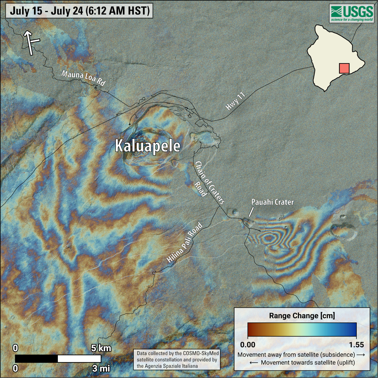
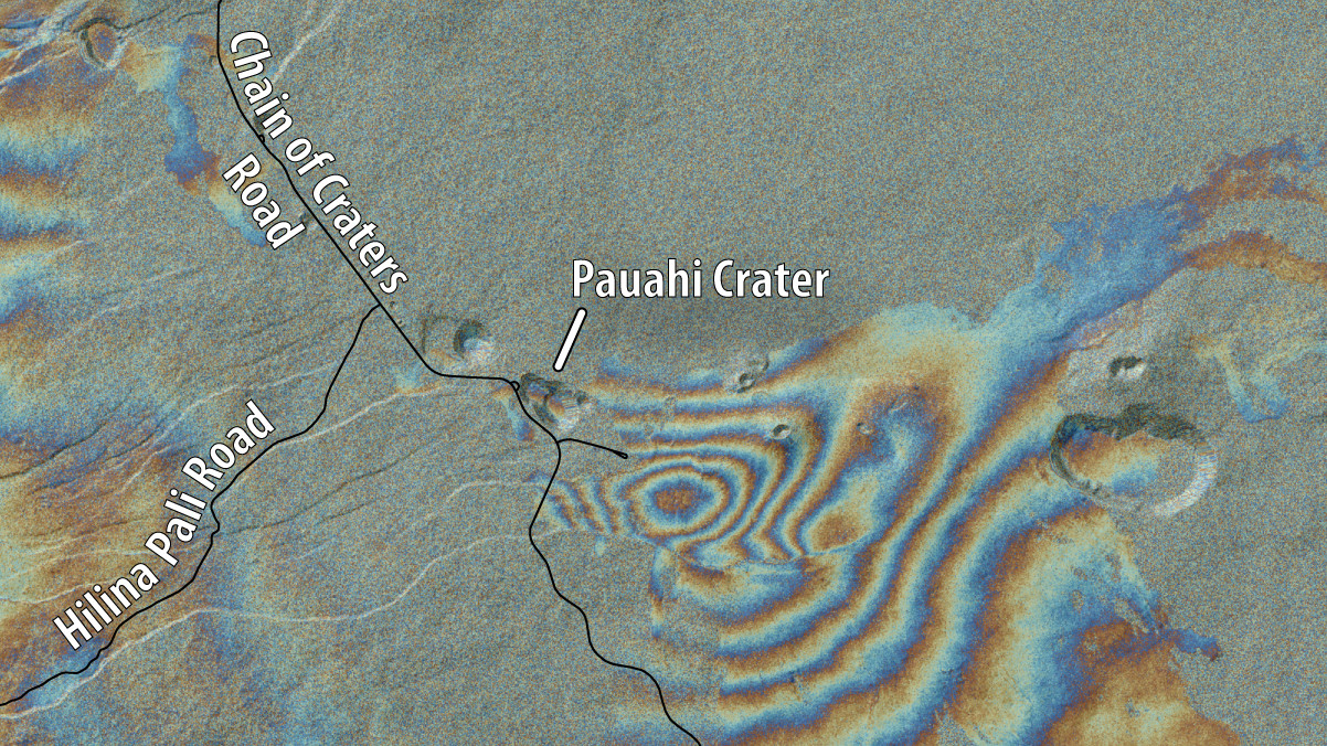
The rapid onset and concentrated intensity of the July 22–24 UERZ swarm, coupled with abrupt changes in UERZ ground deformation patterns, show that an intrusion of magma is occurring in the area of Pauahi Crater. Deformation associated with emplacement of this dike is apparent on a satellite interferogram of the area, confirming ground-based observations. Ongoing seismicity, local deformation, and steady deflation of the summit region indicate that magma is continuing to move underground into the UERZ. The pulsing nature of this recent activity may represent fluctuations in the amount of magma moving underground from the summit to the UERZ.

USGS: “This map shows recent deformation at Kīlauea, over the timeframe of July 15-24, 2024. Data were recorded by the Italian Space Agency’s (ASI) Cosmo-SkyMED satellite. Colored fringes denote areas of ground deformation, with more fringes indicating more deformation. Each color cycle represents 1.5 cm (0.6 in) of ground motion. The bullseye feature southeast of Pauahi Crater on the upper East Rift Zone indicates inflation over this time period due to magma accumulation underground. Arrow in the upper left indicates satellite orbit direction (arrow) and look direction (bar).”
WHAT WE CAN EXPECT
It is not possible to forecast an exact outcome of this activity. Future eruptions are possible with little warning along the upper portions of Kīlauea’s East Rift Zone. Recent Kīlauea eruptions have occurred with as little as 1 hour or less of advanced warning in the form of accelerated rates of ground deformation and earthquakes.
According to the USGS HVO statement, here are some possible scenarios that could play out in the coming days to weeks:
- The intrusion grows: Magma continues to accumulate below the surface near Pauahi Crater on Kīlauea’s UERZ as an intrusion (similar to what occurred during the January/February 2024 intrusion southwest of Kaluapele). In this scenario, we would expect to see varying rates of ground deformation and earthquakes in the direction of the intrusion as it grows, along with summit deflation.
- An UERZ eruption occurs: Magma continues to accumulate below the surface near Pauahi Crater on Kīlauea’s UERZ, resulting in an eventual UERZ eruption. In this scenario, we would expect to see accelerated rates of UERZ earthquakes along with increased rates of Kīlauea summit deflation and UERZ inflation before lava reaches the surface. Based on patterns of past UERZ eruptions, the area most likely for an outbreak would be located between Hiʻiaka crater and Maunaulu.
- The intrusion moves east: Magma continues to accumulate below the surface near Pauahi Crater on Kīlauea’s UERZ, eventually establishing a path to the east, in Kīlauea’s middle East Rift Zone, as occurred during the Father’s Day intrusion in 2007. In this scenario, we would expect to see earthquake locations migrating east of Maunaulu, followed by accelerating rates of summit and UERZ deflationary ground deformation.

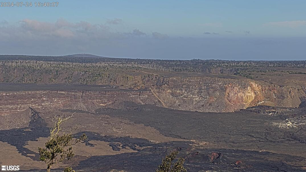
USGS webcam: HVO has re-aimed and zoomed the K2cam, located at Uēkahuna bluff, to view the upper East Rift Zone.
PREVIOUSLY RECORDED ACTIVITY IN THE UPPER EAST RIFT ZONE
Pit craters and lava flows in the UERZ are evidence of a long history of magma moving along this rift zone pathway. Intrusions of new magma into this region have been monitored numerous times in the past decades, with sparse eruptions. During the past 60 years, there have been approximately 50 intrusions and 5 eruptions in the UERZ region. The most recent UERZ eruption took place in November 1979. That was a brief one-day eruption that occurred in and near Pauahi Crater and was preceded by two months of increased earthquake activity along with inflation at the summit region. Several other UERZ eruptions took place in the late 1960s and early 1970s and lasted from one day to about a month. UERZ eruptions have typically occurred near the southeast margin of Kaluapele, or where the UERZ meets the middle East Rift Zone near Pauahi Crater.
The most recent significant intrusion in this area took place in 2007. The “Father’s Day” intrusion began on June 17, 2007, with an earthquake swarm centered southwest of Maunaulu. Over the next several hours, ground deformation rates accelerated and during the next two days, earthquakes propagated downrift towards Puʻuʻōʻō in the middle portion of Kīlauea’s East Rift Zone. Cracks formed at multiple locations in the East Rift Zone, and steam vents formed along the western base and slope of Kāne Nui o Hamo. On the morning of June 19, HVO geologists observed a small amount of fresh lava on the north flank of Kāne Nui o Hamo, which had been erupted overnight of June 19, 2007.
Hawaiʻi Volcanoes National Park says that due to the heightened seismic activity, “Chain of Craters Road is closed at the Devastation intersection to the coast, Kulanaokuaiki Campground is closed, and Escape Road (trail) and Crater Rim Trail are closed south of Nāhuku.”


by Big Island Video News5:15 pm
on at
STORY SUMMARY
HAWAIʻI VOLCANOES NATIONAL PARK - Scientists say there could be an eruption on the upper East Rift Zone, or the intrusion could grow, or move east.