(BIVN) – Kīlauea is not erupting and the USGS Volcano Alert Level remains at ADVISORY.
The Hawaiʻi island volcano continues to show signs of elevated unrest. As of Friday evening, the rate of earthquakes on the upper East Rift Zone appears to be down compared to the uptick that was observed Thursday evening.
All seismic activity on the East Rift Zone is confined to the upper East Rift Zone, with no significant earthquakes occurring past the Pauahi Crater, scientists say.
From the USGS Hawaiian Volcano Observatory report on Friday:
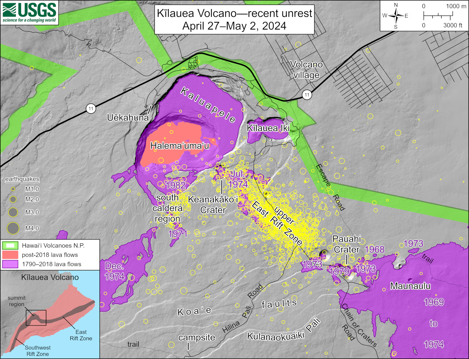
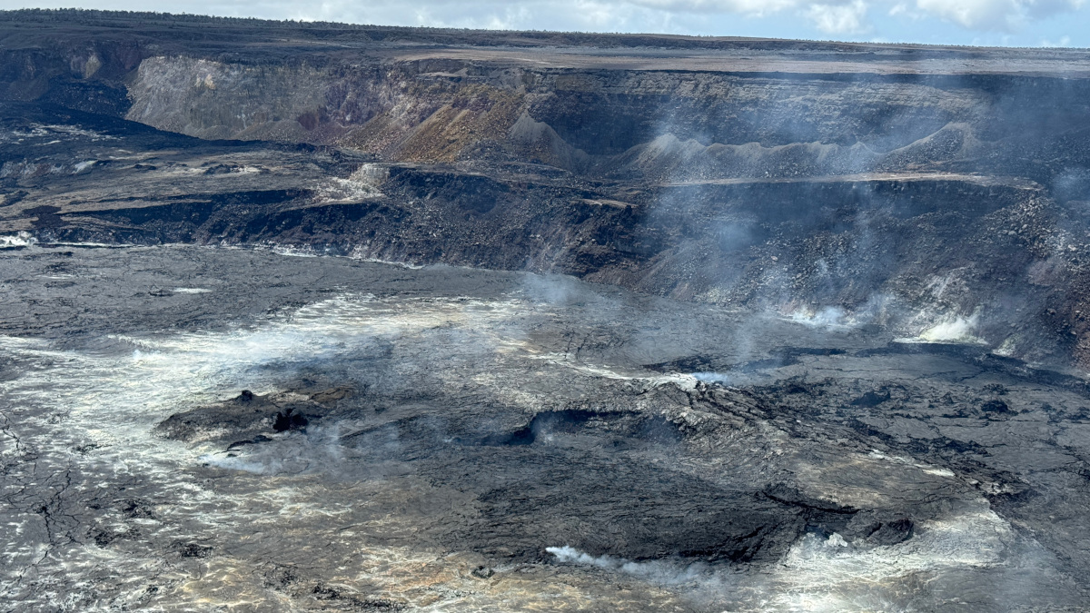
Summit and upper East Rift Zone Observations: Over the past few days, earthquake locations have been focused primarily from the southeast side of Kaluapele (Kīlauea caldera) beneath Keanakākoʻi crater extending to the intersection with Hilina Pali Road. Earthquake counts have not changed significantly in the past three days; there have been approximately 280 earthquakes in this area over the past 24 hours. There have been few earthquakes in the caldera south of Halemaʻumaʻu over this same period. Depths remain concentrated between 2-3 km (1.2-1.9 miles) beneath the surface with scattered shallower and deeper earthquakes. Most earthquake magnitudes have been below M2.5 with the vast majority below M2.0. A series of moderate earthquakes began at 3:50 PM yesterday and lasted approximately 30 minutes with the largest earthquake, a M3.1, felt by communities near the summit.

USGS: This map depicts recent unrest at Kīlauea. Yellow circles mark the locations of approximately 1,600 earthquakes that have occurred between April 27 and May 2, 2024. Most earthquakes have been smaller than magnitude-2, with locations clustering in an area known as the upper East Rift Zone or East Rift connector. This area is reacting to pressurization of magma chambers beneath the summit region of Kīlauea. The upper East Rift Zone area saw several eruptions in the 1960s and 1970s, which are labelled and shown in purple. Most recently, in November 1979, a brief one-day eruption occurred in and near Pauahi crater. In July of 1974, a three-day-long eruption began in Keanakāko‘i Crater, with east-west oriented fissures subsequently opening within Kaluapele and southeast towards Luamanu Crater. A month-long eruption in November 1973 extended from Pauahi Crater east towards Pu‘uhuluhulu. And, a day-long eruption in May 1973 extended from about a half a mile (1 km) west of Hi‘iaka to Pauahi Crater.
Ground deformation continues with ongoing uplift beneath Halemaʻumaʻu and in the region extending from the south end of Kalaupele to the area south of Keanakākoʻi crater . Just before 11:30 PM, the Uēkahuna tiltmeter began recording a deflationary signal, part of a local deflation-inflation (DI) event beneath Halemaʻumaʻu.. The Sandhill tiltmeter continues to record steady inflation with minor changes related to DI events in the southern area.
Sulfur dioxide (SO2) gas emission rates remain low. An SO2 emission rate of approximately 62 tonnes per day was recorded on May 2nd.
Rift Zone Observations: All seismic activity on the East Rift Zone is confined to the upper East Rift Zone, with no significant earthquakes occurring past the Pauahi Crater. At this time, Seismicity south of Kaluapele and in Kīlauea’s Southwest Rift Zone remains low overall. Measurements from continuous gas monitoring stations downwind of Puʻuʻōʻō in the middle East Rift Zone—the site of 1983–2018 eruptive activity—continue to be below detection limits for SO2, indicating that SO2 emissions from Puʻuʻōʻō are negligible.
Analysis: At this time, it is not possible to say with certainty if this increase in activity will lead to an intrusion or eruption in the near future – or simply continue as seismic unrest at depth. Based on past activity in the upper East Rift Zone, the current activity is more likely to result in an intrusion rather than an eruption. However, changes in the location of unrest and the potential for eruption can occur rapidly.
Temporary closures within Hawaiʻi Volcanoes National Park include:
- Chain of Craters Road from the intersection at Crater Rim Drive will close at 5 p.m. Monday, April 29.
- Hilina Pali Road is closed to all use. Kulanaokuaiki Campground is closed.
- Overnight camping is suspended for all coastal sites, Nāpau and Pepeiao Cabin.
- Kaʻū Desert Trail is closed from the Footprints Exhibit.
- Maunaiki Trail is closed.


by Big Island Video News3:55 pm
on at
STORY SUMMARY
HAWAIʻI VOLCANOES NATIONAL PARK - Elevated seismicity continues beneath the upper East Rift Zone, as does the inflation in the caldera south of Halemaʻumaʻu that began on April 27th.