(BIVN) – Kīlauea is not erupting and the USGS Volcano Alert Level remains at ADVISORY, as scientists continue to monitor the significant increase in seismicity beneath the upper East Rift Zone and caldera south of Halemaʻumaʻu that started over the weekend and continued Tuesday.
Although the alert level for Kīlauea has not yet been raised to WATCH, the USGS Hawaiian Volcano Observatory stated today that “the gradual strengthening of seismic swarms suggests that an eruption in Kīlauea’s summit region or beneath the upper East Rift Zone, within Hawai‘i Volcanoes National Park, is one potential outcome.”
Due to the increased number of earthquakes, Hawaiʻi Volcanoes National Park is maintaining several temporary closures inside the park, including:
- Chain of Craters Road from the intersection at Crater Rim Drive will close at 5 p.m. Monday, April 29.
- Hilina Pali Road is closed to all use. Kulanaokuaiki Campground is closed.
- Overnight camping is suspended for all coastal sites, Nāpau and Pepeiao Cabin.
- Kaʻū Desert Trail is closed from the Footprints Exhibit.
- Maunaiki Trail is closed.
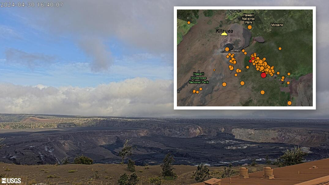
Scientists continue to report all seismic activity on the East Rift Zone is confined to the upper East Rift Zone, with no significant earthquakes or deformation occurring past the Mauna Ulu region.
From the USGS Hawaiian Volcano Observatory on Tuesday, April 30th:
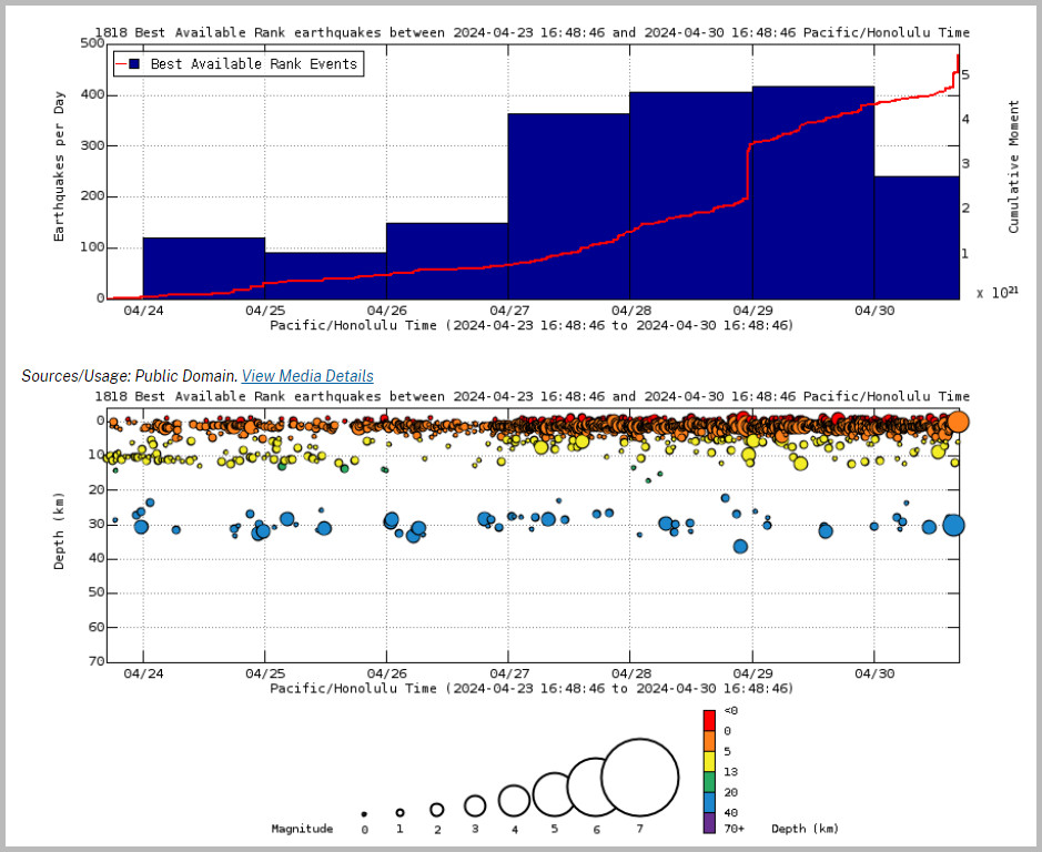
Summit and upper East Rift Zone Observations: Earthquake activity increased sharply just after midnight on April 27 beneath the upper East Rift Zone and beneath Kīlauea caldera south of Halemaʻumaʻu. Earthquake locations beneath the upper Easth Rift Zone continue to be focused primarily between Puhimau Crater and Hilina Pali Road, with slight expansion northwest toward Keanakākoʻi Crater and southeast toward Pauahi Crater over the past 24 hours. Earthquakes are occurring at depths of 1.5-2.5 km (1-1.5 miles) beneath the surface. There were over 360 earthquakes in the past 24 hours, about the same number as the previous 24 hours, located mostly beneath the upper East Rift Zone with fewer in the caldera south of Halemaʻumaʻu. Unlike the previous 24 hours, no earthquakes greater than magnitude-3 were observed in the past 24 hours. Most earthquakes were less than magnitude-2 punctuated by occasional larger earthquakes with magnitudes between 2 and 3. Activity is ongoing at a rate of about 15 earthquakes per hour.

From USGS: Earthquake Rates and Depths as of noon on Monday. Above Top: Number of earthquakes per day during the past week (blue bars). The red line is the cumulative moment (energy) release. Bottom: Depth of earthquakes during the past week in the area shown on the map above. Depth is reported relative to sea level, which is equal to a depth of zero on the above plot. On both figures, circle-size represents magnitude, and color indicates depth.
Accelerated rates of ground deformation continue with ongoing overall inflation of the summit and uplift south of the caldera. Tiltmeters near Uēkahuna and Sand Hill showed increased rates of inflation and uplift yesterday until about 6:00 PM when rates decreased slightly with the onset of a deflation-inflation (DI) event.
Sulfur dioxide (SO2) gas emission rates remain low. An SO2 emission rate of approximately 52 tonnes per day was recorded on April 23.


by Big Island Video News5:05 pm
on at
STORY SUMMARY
HAWAIʻI VOLCANOES NATIONAL PARK - Scientists have observed accelerated rates of ground deformation amid a significant increase in seismicity.