UPDATE – (4:50 p.m.) – In the late afternoon, the National Park Service expanded the closures to include the Chain of Craters Road from the intersection at Crater Rim Drive. The closure begins at 5 p.m. this evening (Monday, April 29th)
(BIVN) – Temporary closures are in effect within Hawaiʻi Volcanoes National Park, as officials are keeping a close eye on a recent spike in earthquakes under Kīlauea volcano.
Kīlauea is not erupting, but the volcano has been in a heightened state of unrest since this weekend. There has been a significant increase in seismicity beneath the upper East Rift Zone and caldera south of Halemaʻumaʻu. As a result, the National Park Service has decided “to close some areas that could put visitors and staff at risk if the volcano erupts.”
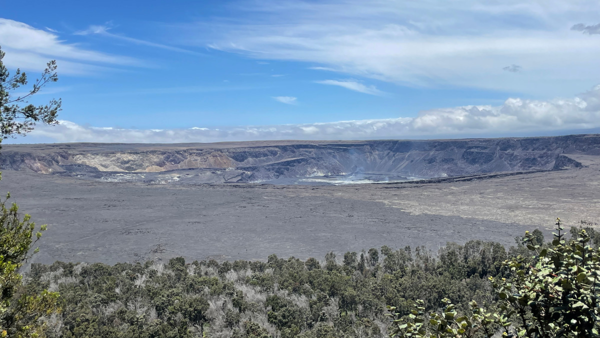
Panoramic view of Kaluapele, the Kīlauea summit caldera, on Monday afternoon, April 29th. Photo was taken from an overlook on Crater Rim Trail near Volcano House that is open to the public. (NPS photo)
The temporary closures include:
- Hilina Pali Road is closed to all use. Kulanaokuaiki Campground is closed.
- NEW: Chain of Craters Road from the intersection at Crater Rim Drive.
- Overnight camping is suspended for all coastal sites, Nāpau and Pepeiao Cabin.
- Kaʻū Desert Trail is closed from the Footprints Exhibit.
- Maunaiki Trail is closed.
“Safety is our main focus, and the uncertainty of where an eruption could break out increases risk,” said Chief Ranger Jack Corrao in a Monday news release. “Elevated volcanic gases, dangerous lava activity, damaging earthquakes and lava-ignited wildfire are all potential hazards associated with an eruption.”
From the National Park Service news release:
According to the USGS Hawaiian Volcano Observatory, it is not possible at this time to know if this increase in activity will lead to an eruption in the near future or simply remain confined below ground. However, the gradual strengthening of seismic swarms suggests that an eruption in the summit region of Kīlauea or beneath the upper East Rift Zone in the park is one potential outcome.
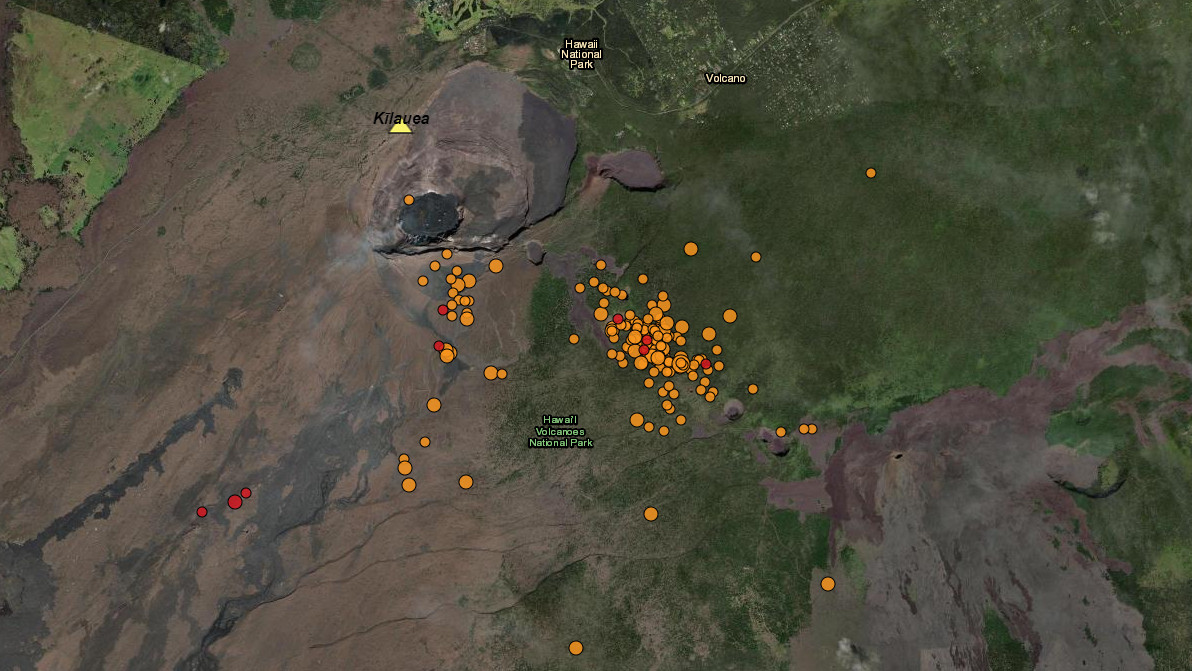
About 360 shallow earthquakes in the last 24 hours have ping-ponged between areas south of Kīlauea caldera to the upper East Rift Zone across Chain of Craters Road near Puhimau Crater, adding to the uncertainty of where an eruption could occur. Their magnitude has ranged from M-1 to M-3.
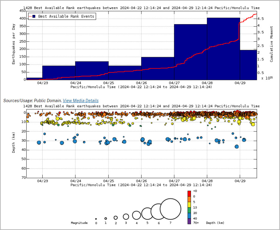
From USGS: Earthquake Rates and Depths as of noon on Monday. Above Top: Number of earthquakes per day during the past week (blue bars). The red line is the cumulative moment (energy) release. Bottom: Depth of earthquakes during the past week in the area shown on the map above. Depth is reported relative to sea level, which is equal to a depth of zero on the above plot. On both figures, circle-size represents magnitude, and color indicates depth.
The increased seismicity has not impacted traffic safety or infrastructure projects at the summit.
Hawaiʻi Volcanoes National Park encompasses two of the world’s most active volcanoes, making it distinct among national parks. In 2022, the park closed the summit of Mauna Loa weeks ahead of its historic and nearly two-week eruption. As a result, no evacuations or search and rescue missions were necessary.
Other popular locations in Hawaiʻi Volcanoes National Park remains open to the public, including Kīlauea Visitor Center, overlooks along Crater Rim Trail, Volcano House, Nāhuku lava tube, Chain of Craters Road and more. Closures and hazard alerts can be found on the HVNP website.

by Big Island Video News
on at
STORY SUMMARY
HAWAIʻI VOLCANOES NATIONAL PARK - The National Park Service explains the recent decision to close certain areas in the park due to the latest spike in earthquakes.