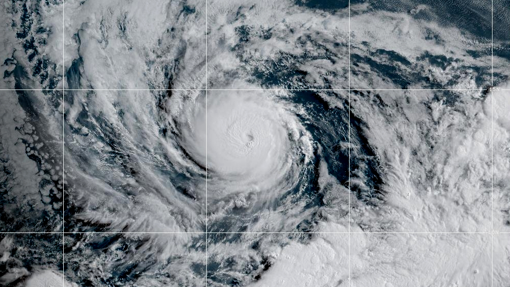
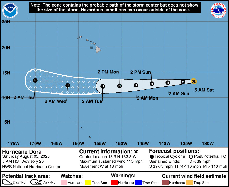
(BIVN) – Hurricane Dora – 1,535 miles east of South Point on Hawaiʻi island as of 5 a.m. HST Saturday morning – has become a major hurricane once again.
Maximum sustained winds have increased to near 115 mph with higher gusts, making Dora a category 3 hurricane on the Saffir-Simpson Hurricane Wind Scale. Little change in strength is expected today as Dora heads towards the Central Pacific.
“While it should continue to be monitored, models show Dora passing south of the islands with deep high pressure moving in tandem to the north of Hawaii” early next week, the National Weather Service wrote this morning. “This will result in a strong and rather dry trade wind flow with scant showers.”
“Under this stable and strong flow, winds over and downwind of terrain should exceed the Wind Advisory threshold, and localized damaging wind gusts to High Wind Warning levels are a real possibility,” the forecasters said.
Dora is expected to bring large surf to the eastern end of the state, where heights may near the warning level late Monday through Tuesday night.
The County of Hawaiʻi County says it is closely monitoring the development of Hurricane Dora and other related weather patterns.
“At this time, there are no plans to cancel any outdoor events scheduled through the weekend,” county officials wrote in a Friday news release. “However, the County urges all event organizers, participants, and attendees to remain vigilant and stay updated on the latest weather advisories from official sources. Residents should be prepared for potential changes should the weather situation evolve.”
From the National Hurricane Center at 5 a.m. HST on Saturday:
The increase in Dora’s organization that started just before the last advisory has continued during the last several hours, with a cloud-filled eye becoming more persistent in a central dense overcast with some cloud top temperatures colder than -80C. The various satellite intensity estimates are now in the 95-120 kt range, and the initial intensity is increased to a possibly conservative 100 kt.
Dora continues moving westward or 265/16 kt along the southern side of a deep-layer ridge to the north. This ridge is expected to build westward, which should induce a somewhat faster forward speed while it passes well south of Hawaii early next week. The track guidance is still tightly clustered and has changed little since the previous advisory, and the new track forecast is almost the same as the previous forecast.
The easterly shear that occurred yesterday seems to be decreasing, with that decrease probably allowing the re-intensification. During the next 48-72 h, the center of Dora should be in a light-shear environment with sea surface temperatures of 26-27C. While there is still some spread, the intensity guidance indicates that the current intensification should end in the next 6-12 h, followed by a gradual weakening. This part of the intensity forecast follows the guidance and is a little above the intensity consensus. After 72 h, the hurricane is expected to move over increasing sea surface temperatures, but also move into a drier air mass. In addition, some westerly vertical shear could develop by 120 h. However, the guidance spread becomes quite large, with the GFS- and ECMWF-based SHIPS models showing a significantly higher intensity than the dynamical models. This part of the intensity forecast will show a slow weakening, but will lean more towards the SHIPS models than the dynamical models.


by Big Island Video News7:10 am
on at
STORY SUMMARY
HONOLULU, Hawaiʻi - Models show Dora passing south of the Hawaiian islands early next week, bringing large surf and high winds.