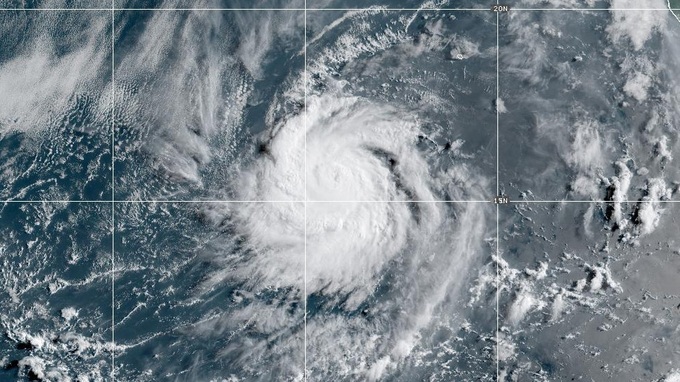
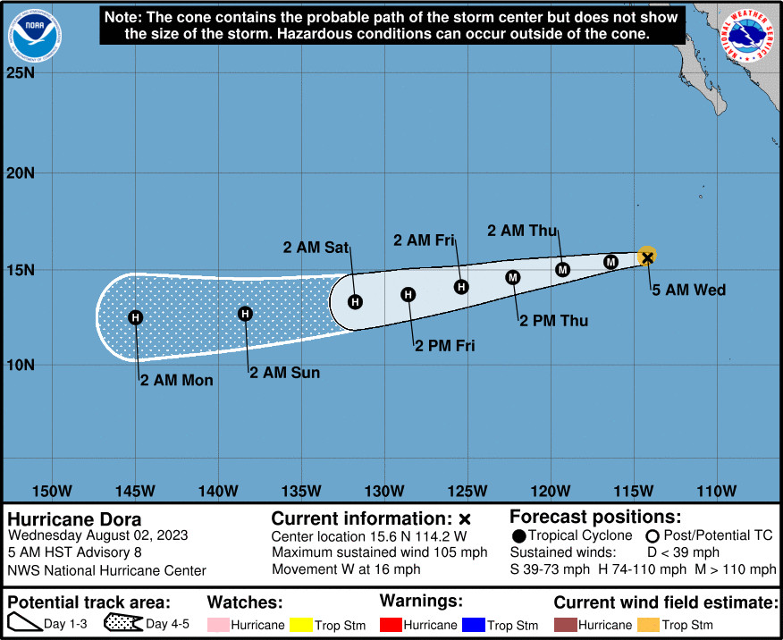
(BIVN) – Small Hurricane Dora is rapidly intensifying in the Eastern Pacific and is forecast to become a major hurricane later today.
Hurricane Dora was 575 miles south southwest of the southern tip of Baja California as of 5 a.m. HST on Wednesday.
Dora is moving toward the west near 16 mph. Hurricane-force winds, measured at 105 mph, extend outward from the center of Dora up to 10 miles, making Dora a small hurricane.
“Latest forecast from the National Hurricane Center in Miami, Florida indicates that Hurricane Dora will cross 140W, and into the central Pacific late this weekend,” wrote the National Weather Service in Honolulu on Wednesday morning. “Thereafter, Dora is expected to move on a path that would generally keep it well S of the islands early next week. This scenario would bring an increase in trade wind speeds Monday and Tuesday. As a deep-layer high to the NE builds westward, winds could become strong as the trade wind flow becomes quite dry.”
Forecasters note that the Keetch-Byram Drought Index values will potentially exceed 600 for the first time this summer as Dora passes south, brining Red Flag fire conditions to Hawaiʻi.
“The potential for a near advisory east swell may be generated by Hurricane Dora that will impact east facing shores early next week,” the Honolulu forecasters wrote. “This east swell remains highly reliant on Dora’s track, intensity, and size of the fetch.”
From the National Hurricane Center discussion on Wednesday morning:
Dora continues to rapidly intensify this morning. Overnight infrared and first-light visible satellite imagery indicates that Dora has a small but tight inner core, with a pinhole eye starting to emerge from the central dense overcast cirrus. An AMSR2 microwave pass at 850 UTC showed this tiny core structure well, though some residual dry air was still noted between the inner core and the curved banding on Dora’s west side. Subjective Dvorak intensity estimates were T5.0/90 kt from TAFB and T4.5/77 kt form SAB, while the latest objective ADT estimate was 84 kt. Given the improvement in structure on satellite imagery since 1200 UTC, the initial intensity this advisory is set at 90 kt, on the higher end of those estimates.
Dora continues to move just south of due west, at about 260/14 kt. The track reasoning has not changed much over the past day, with a well-established deep-layer ridge to the north of Dora expected to steer the system westward to west-southwestward for most of the forecast period. The latest NHC track continues to blend the simple and corrected consensus aids (TVCE and HCCA), and is nearly on top of the previous forecast track, if just a bit faster at the end of the forecast period.
Dora is in the middle of a rapid intensification (RI) cycle, and most of the guidance suggests that RI should continue for the next 12-24 h or so. Thus, the intensity forecast in the short-term was raised again, now showing a peak of 115 kt in 24 h. This intensity is just a little higher than the HCCA and IVCN consensus aids, but remains lower than the latest HAFS-A/B guidance. Afterwards, Dora’s small inner core could begin to undergo structural changes, such as an eyewall replacement cycle. GFS-SHIPS guidance also shows easterly shear increasing over the system as sea-surface temperatures gradually decrease down to 27 C. A combo of these factors should result in some gradual weakening, which is reflected in the latest NHC intensity forecast beginning at 36 h, following the consensus aids most closely. However, the small size of Dora could make the system prone to more rapid intensity changes than reflected here.


by Big Island Video News6:04 am
on at
STORY SUMMARY
HONOLULU - Hurricane Dora is expected to move on a path that would generally keep it well south of the Hawaiian islands early next week.