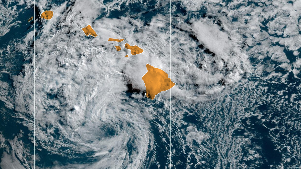
(BIVN) – A Tropical Storm Warning is still in effect for Hawaiʻi island, as Tropical Storm Calvin, currently located near South Point on the Big Island, moves west. Forecasters say periods of heavy rainfall, damaging winds, and life threatening surf are still possible this morning.
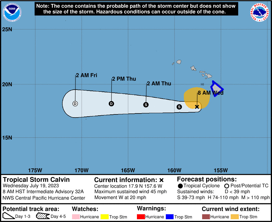
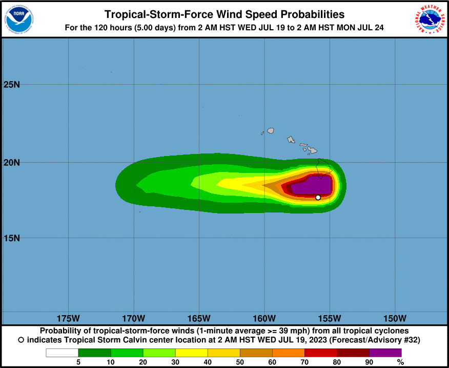
As of 8 a.m. HST, Calvin was located 105 miles southwest of South Point (205 miles southwest of Hilo) with maximum sustained winds of 45 mph. Tropical-storm-force winds extend outward up to 125 miles from the center.
A Flash Flood Warning was issued for the windward side of Kaʻū, where Wood Valley Road has been closed due to flooding. “Flooding is also expected to close the Hawaiʻi Belt Road in the Kawa Flats area near Punaluʻu, and Kaʻalaiki Road near Pahala,” forecasters said. “Rainfall will continue over the Kaʻū District through the morning.”
A reported landslide also closed Old Mamalahoa Highway in Oʻokala on the Hāmākua coast this morning.
Flooding was also reported in Puna, with water flowing over Pohaku Drive and 39th Avenue in Orchidland Estates.
From the National Weather Service in Honolulu at 5 a.m. HST:
Big Island Impacts… Strong damaging Tropical Storm Force winds and heavy rainfall leading to flash flooding are likely with this storm. Rainfall rates of 3 inches per hour will develop in some areas, increasing the threat of flash flooding and rock/mud slides through at least this morning. Over the past 12 hours 3 to 5 inches of rain has fallen over eastern slopes of the Big Island, and an additional 2 to 4 inches are possible as Calvin moves away from the island. The greatest rainfall and flood threats will likely occur near Hilo, and over the Puna and Kaʻu Districts. The greatest wind accelerations are expected over areas around and downwind of terrain such as the saddles, South Point and the Kohala districts. Winds this strong will be capable of knocking down trees and causing power outages, so please limit travel if possible until the storm passes. Conditions are expected to quickly improve by this afternoon with high pressure moves in from the east.
A High Surf Warning remains in effect, as dangerously large and disorganized waves of 14 to 18 feet are possible along exposed east facing shores of Hawaiʻi island.
This update on Tropical Storm Calvin was provided by the Central Pacific Hurricane Center at 5 a.m. HST:
Deep convection around Calvin collapsed overnight, leaving residual deep convection across east and southeast-facing shores and slopes of the Big Island and Maui. This is the result of deep tropical flow interacting with terrain. Calvin’s low level circulation center (LLCC) has become completely exposed, allowing small corrections in initial position and movement for this advisory. Instruments aboard the US Air Force Reserve’s Hurricane Hunter aircraft showed maximum flight level winds of 47 kt, reduced to about 42 kt at sea level. Subjective Dvorak satellite analyses from PHFO and JTWC gave current intensity numbers of 2.5, 35 kt and 2.0, 30 kt, respectively. UW-CIMSS derived an ADT intensity of 37 kt, while an ASCAT pass from last evening showed maximum winds of about 40 kt within Calvin’s northeast quadrant. Based on these data, the initial intensity for this advisory has been decreased to 40 kt.
The initial motion for this advisory is unchanged at 275/17 kt as Calvin continues to move south of a large subtropical ridge. No significant change in this steering is expected over the next several days. Calvin is about to complete its passage south of the Big Island and the forecast track is essentially the same as the previous forecast track, aside from small changes in initial position and forward speed from tau 12 and beyond. The total track is shorter as this system is forecast to dissipate at tau 60. The forecast track remains within, but on the southern side, of the guidance envelope. Although the center of Calvin is passing south of the Big Island, much of the island remains within the 34 kt radius, and impacts from strong winds, heavy rainfall, and high surf are occurring.
The forecast calls for Calvin to finish its passage south of the Big Island this morning, then continue moving westward away from the main island chain as a weakening tropical storm. Vertical shear affecting the tropical cyclone is expected to be moderate today, then strong by tonight. The strong shear should result in weakening to post-tropical/remnant low status late Thursday night.
KEY MESSAGES:
1. Calvin has almost completed its passage south of Hawaii County. Expect periods of flash flooding, dangerous surf and damaging winds. Calvin will continue to weaken as it moves westward to the south of the other Hawaiian Islands today and tonight, bringing the potential for some peripheral impacts.


by Big Island Video News8:20 am
on at
STORY SUMMARY
HAWAIʻI ISLAND - Flooding is reported in the Kaʻū and Puna districts this morning, and a landslide was reported in Oʻokala.