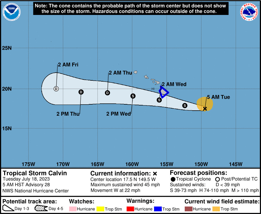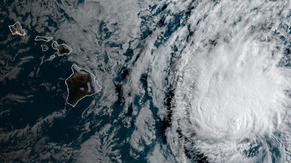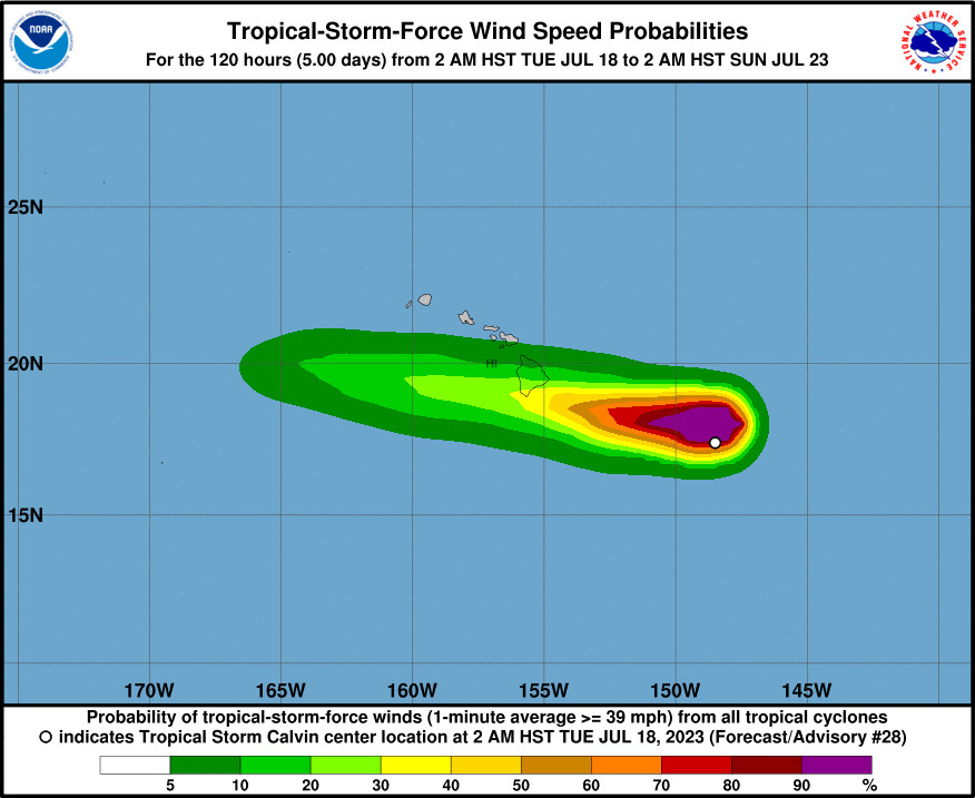
Forecast map by NWS Central Pacific Hurricane Center. “It is important to not focus on the exact forecast track and intensity when preparing for Calvin,” the CPHC says. Tropical-storm-force winds extend outward up to 105 miles (165 km) from the center.
(BIVN) – Tropical Storm Calvin will impact Hawaiʻi island tonight, officials say, bringing a period of heavy rain, high surf and locally strong winds to the Big Island.
“The center of Tropical Storm Calvin is forecast to pass over, or just south of, the Big Island of Hawaii tonight and early Wednesday,” the National Weather Service wrote on Tuesday, “then pass well south of the other Hawaiian Islands through Wednesday night. This places the islands in the windier and wetter part of Calvin’s circulation. Impacts are expected to be greatest on the Big Island, but strong and gusty winds, locally heavy rainfall and high surf along east facing shores can be expected statewide.”
A Tropical Storm Warning is in effect for Hawaiʻi island. Also, a Flood Watch and High Surf Warning are in place. Surf may reach as high as 15 feet along east facing shores of the Big Island, forecasters say.
Calvin was 395 miles east southeast of Hilo as of 5 a.m. on this morning. Maximum sustained winds are near 45 mph (75 km/h) with higher gusts. Meteorologist noted deep convection has been developing near Calvin early this morning, which they say “may slow the weakening trend today.”
These details were provided by the National Weather Service at 5 a.m. HST:
Wind Impacts: Calvin remains on a high confidence westerly track with the ridge north of the islands providing the main steering flow. This storm will continue to weaken as it approaches the Big Island due to cooler water temperatures, the ingest of stable dry air, and some vertical wind shear. However, Tropical Storm Force winds remain in the forecast as the center of the system passes near the south side of the Big Island tonight through early Wednesday morning. A Tropical Storm Warning remains in effect for the Big Island and surrounding waters due to the island’s proximity to the Tropical Storm Force wind speeds surrounding the storm. Wind speeds will also increase statewide today through Wednesday as the storm remains on a track passing south of the smaller Hawaiian Islands. These winds will strengthen due to the increasing pressure gradient between the ridge to the north and the low pressure center associated with Calvin passing to the south. This means that wind speeds over the islands in Maui County will at least reach Wind Advisory thresholds and may exceed High Wind Warning criteria in some areas, even as Calvin weakens and passes to the south. Wind speeds will accelerate over and downwind of mountain slopes with stronger gusts expected. A Wind Advisory remains in effect today for all islands in Maui County, A High Wind Watch was also issued for Maui County starting tonight for stronger winds expected on Wednesday. Additional Wind Advisory and High Wind Watch or Warning products may need to be extended to Oahu on Wednesday as Calvin passes to the south. For the moment, Kauai County will see less wind impacts from Calvin based on the latest storm track and intensity.
Rainfall Impacts: Deep unstable tropical moisture surrounding Calvin will be driven up mountain slopes due to the strong wind forcing as the Tropical Storm passes each island. This means the potential for flash flooding remains elevated even for islands not directly in the path of the Tropical Storm. How far north these heavy rainfall impacts will occur is the forecast challenge with this event. The highest potential for heavy rain and flooding are expected along the windward slopes of the Big Island and windward slopes of the eastern half of Maui. Storm total rainfall amounts in the 4 to 8 inch range should be expected for the eastern slopes of the Big Island from North Kohala to the Hamakua Coast to Hilo to South Point, with 1 to 2 inches of rain forecast over the Kona side of the island. Maui may see between 2 to 6 inches of storm total rainfall from the North Shore near Haiku to East Maui near Hana. Other islands will see lower amounts between 0.25 to 2 inches, with locally higher amounts possible favoring windward mountains and slopes. The Flood Watch remains in effect with the potential for flash flooding starting this evening over the Big Island and Maui County. This Flood Watch was expanded in coverage to include Oahu, Kauai and Niihau this morning, with enhanced flood threats to Oahu forecast to start early Wednesday morning potentially impacting the western islands.
Hawaiʻi County officials on Monday said two emergency shelters were being readied in the Kaʻū district at The Robert Herkes Gymnasium in Pāhāla and the Nāʻālehu Community Center. County Camping Permits have been cancelled from Tuesday, July 18, through Wednesday, July 19.
At Hawaiʻi Volcanoes National Park, backcountry sites will close this evening. Also, the After Dark in the Park program with Don Swanson Tuesday night will be rescheduled, and the Visitor Center will close at 5 p.m.
From the Central Pacific Hurricane Center discussion posted at 5 a.m. HST:
A large area of thunderstorms continues to expand in coverage near the partially exposed low-level circulation center (LLCC) of Tropical Storm Calvin. An aircraft from the 53rd Weather Reconnaissance Squadron “Hurricane Hunters” completed sampling Calvin a few hours ago. They found winds at flight-level and from dropwindsondes that suggested the peak surface wind speeds were close to 40 kt. The most recent subjective Dvorak satellite intensity estimates were 35 kt from PHFO and JTWC. The latest CIMSS SATCON intensity estimate indicates 45 kt. The initial intensity for this advisory is maintained at 40 kt based on a blend of these estimates.
Calvin’s initial motion for this advisory remains 275/19 kt as the cyclone continues to be steered rapidly westward south of a large subtropical ridge. This steering is expected to continue over the next 3 to 4 days. The latest model guidance, including the HCCA, indicates that the center of Calvin will pass over, or just south of the Big Island tonight. The latest track forecast is close to the previous forecast.
The surrounding environment around Calvin continues to be somewhat dry and stable. The SSTs are gradually increasing to around 25C, and we expect additional warming of the SSTs to 26-27C as it moves closer to the main Hawaiian Islands. The higher SSTs will likely support additional deep convection spreading around the northern semicircle of Calvin at least into Wednesday. This is expected to keep the cyclone at tropical storm intensity during the next 36 hours or so. As a result, a Tropical Storm Warning remains in effect for Hawaii County. After it passes southwest of the main Hawaiian Islands, we expect Calvin to move near an upper tropospheric trough by day 2. This feature aloft will likely increase the vertical wind shear over the system, and will eventually result in it becoming a post-tropical/remnant low by late Thursday. Finally, another “Hurricane Hunter” aircraft is scheduled to fly a sampling mission into Calvin a few hours after daybreak this morning. They will monitor any significant changes in intensity and size as the system moves toward the Big Island.
KEY MESSAGES:
1. Calvin is forecast to pass over, or very close to Hawaii County tonight, bringing a period of heavy rain, high surf and locally strong winds. Calvin is expected to weaken as it moves westward to the south of the other Hawaiian Islands Wednesday and Wednesday night, bringing the potential for some peripheral impacts.
2. It is important to not focus on the exact forecast track and intensity when preparing for Calvin. Persons in Hawaii County should prepare during daylight hours for impacts prior to the onset of tropical storm conditions, which are expected to start this evening. These impacts could include flash flooding, damaging winds, and large and dangerous surf.


by Big Island Video News7:53 am
on at
STORY SUMMARY
HAWAIʻI ISLAND - A Tropical Storm Warning remains in effect for the Big Island, where Calvin is expected to arrive tonight.