Tropical Storm Warning: TS Calvin Impacts Hawaiʻi Tuesday Night (A synthesized voice was utilized in the narration for this story)
(BIVN) – Hawaiʻi State and County officials announced multiple closures and cancellations on Tuesday, as Tropical Storm Calvin – only 245 miles east southeast of Hilo as of 11 a.m. HST – is set to impact the Big Island later this evening.
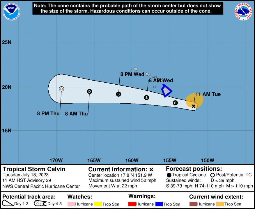
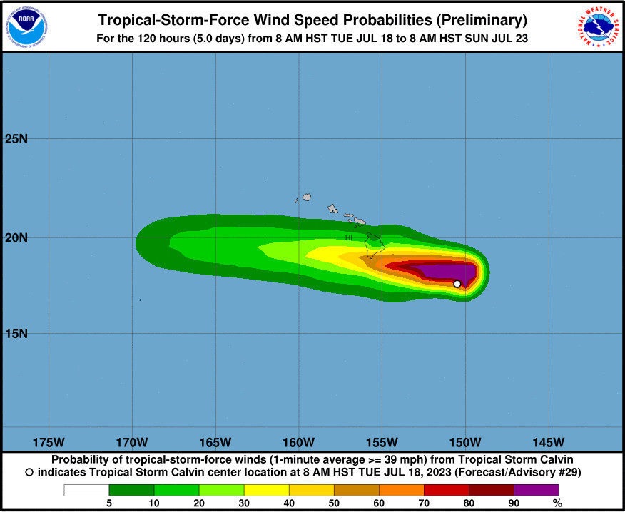
A Tropical Storm Warning is in effect for Hawaiʻi island, where there will be the possibility of flash flooding, damaging winds, and large and dangerous surf as a result of Calvin, which is forecast to pass very close to the island tonight.
Hawaiʻi Governor Josh Green today signed an Emergency Proclamation ahead of Calvin’s arrival to make resources available to address potential storm impacts.
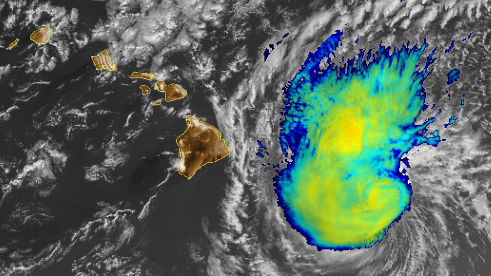
The tropical storm’s maximum sustained winds increased today, and are now near 50 mph with higher gusts. A large area of deep convection developed overnight in the northern semicircle of Calvin’s circulation, forecasters say.

Forecast map by NWS Central Pacific Hurricane Center. “It is important to not focus on the exact forecast track and intensity when preparing for Calvin,” the CPHC says. Tropical-storm-force winds extend outward up to 115 miles (165 km) from the center.
“Hires models are indicating periods of heavy rainfall over the windward side and southeast flank of the Big Island tonight through Wednesday morning,” wrote the National Weather Service at 11:36 a.m. HST on Tuesday. “Rainfall rates of 3 inch per hour will be possible at times, which will bring the threat of flash flooding and rock/mud slides tonight. Rainfall totals of 4 to 8 inches are expected with isolated pockets of higher amounts. The greatest rainfall will likely occur over north and south Hilo, Puna and Kau districts. With most of this rainfall occurring in a relatively short time frame (around 12 hours) flooding will become an issue for any low lying areas and poor drainage areas.”
“Damaging tropical storm force winds with wind gusts of over 60 mph will also be an issue with the greatest wind accelerations expected over areas over and downwind of terrain such as the saddles and the Kohala districts,” the Honolulu-based forecasters wrote. “The timing for the potential damaging winds looks to be from tonight through Wednesday morning.”
“Dangerously large and disorganized waves of 10 to 15 feet” will impact east-facing shores of the Big Island, which are currently under a High Surf Warning.
Hawaiʻi County officials provided these updates at noon on Tuesday:
Expanded Emergency Shelters: The following locations will open today at 2 p.m. HST to provide safe shelter: Pāhoa High School, Hilo High School, Keaʻau Armory, Robert Herkes Gymnasium in Pahala, Nāʻālehu Community Center, Honokaa High School, Hisaoka Gymnasium in Kohala, and Waimea Elementary School. “We want to remind residents that these shelters are pet-friendly, and pet owners must bring carriers and necessary animal supplies,” the County said.
County Parks Closure: All County parks will close at 4 p.m. today (July 18) and remain closed through tomorrow, (July 19). “The County encourages residents to seek safe shelter and avoid visiting parks during this period,” the County said.
(UPDATED) State Parks: The Hawai’i DLNR says all 14 Hawaiʻi island State Parks and campsites will close at 4 p.m. today and will remain closed tomorrow. All DLNR Division of State Parks offices will also be closed tomorrow. Parks will reopen following assessments of any damage. The DLNR Division of Boating and Ocean Recreation does not have any anticipated closures, officials say, but staff on the Big Island are working with any boaters that may have questions.
County Facilities: County offices and facilities, including the Vehicle Registration and Licensing Division and Transfer Stations, will remain closed for the safety of the public and staff. Animal Control services will remain open to address any emergency animal needs during the storm.
Hawaiʻi Courts: All Third Circuit (Hawaiʻi island) courts and Judiciary facilities will be closed on Wednesday, July 19. The Hawaiʻi State Judiciary expects to reopen on Thursday, July 20th.
Hawaiʻi County Mass Transit: The following Hele-On route changes will be in effect:
July 18, 2023:
- Route 2 at 1:15, 4:45 pm (to Kona) & 5:00, 7:45 pm (to Hilo) – CANCELLED
- Route 60 at 2:05 pm (Hilo to Honokaa/Kona) & 8:26 pm (to Hilo)– CANCELLED
- Route 76 at 3:19 pm (Honokaa to Kona) & 6:00 pm (to Honokaa) – CANCELLED
- Route 80 at 7:15 pm (to S. Kohala/KOA) & 11:00 pm (to Hilo) – CANCELLED
- Route 90 at 12:30 pm (to Kona) & 5:00 pm (Southbound to Pahala) – CANCELLED
- Route 101, 102, 103, 104 – Services will end at 7:00 pm
- Route 201, 202, 203, 204 – Services will end at 7:00 pm
- Route 40, 401, 402 – Services will end at 7:00 pm
July 19, 2023:
- All routes will be canceled and will be re-evaluated at 9:00 am.
Hawaiʻi County Council meetings: The County Clerk announced the following meeting cancellations and rescheduling:
- Committee on Government Operations and External Affairs: Originally scheduled for 1:00 pm on July 18 – Cancelled. Rescheduled for July 25, 2023, at 10:30 am.
- Committee on Finance: Originally scheduled for 9:00 am on July 19 – Cancelled. Rescheduled for July 25, 2023, at 9:00 am.
- Regular Council Meeting: Originally scheduled for 10:00 am on July 19 – Cancelled. Rescheduled for July 26, 2023, at 9:00 am.
State Offices in Hawaiʻi County: “In partnership and coordination with the County of Hawaiʻi, state offices in the County of Hawaiʻi will be closed on Wednesday, July 19, 2023 due to expected severe weather conditions,” a state news release reported. “This will allow for employees to take precautions and safety actions as they prepare for and respond to the effects of Tropical Storm Calvin, which is expected to impact the state beginning this evening.” Non-essential employees affected by the closing of those offices should not report to work and shall be granted Administrative Leave, EXCEPT for:
- Departmental Disaster/Emergency Coordinators,
- Disaster Response Workers, and
- Employees whose work involves continuing crucial operations/services, such as hospital workers, correctional workers, etc.
Employees who fall into one of the above categories are required to report to work to ensure essential operations continue throughout the County of Hawai‘i.
This storm analysis was provided by the Central Pacific Hurricane Center at 11 a.m. HST:
A large area of deep convection developed overnight in the northern semicircle of Calvin’s circulation. This convection has persisted through this morning and has obscured the low level circulation center that was so clearly visible yesterday. Fortunately, the US Air Force Reserve has a WC-130J flying a mission into the system today that has helped better identify the system’s center and surrounding wind field. SFMR data indicated 46 kt in the NE quadrant and a large area of winds at or above 34 kt. As a result, the initial intensity for this advisory has been increased slightly to 45 kt. The 34 kt radius in the NE quadrant has also been increased as well.
The initial motion for this advisory is 280/19 kt as Calvin continues to move south of a subtropical ridge. No significant changes in this steering is expected over the next several days. The main objective aids have the center of Calvin passing south of the Big Island tonight. The track forecast is essentially the same as the previous advisory and is on the northern side of the guidance envelope, but still south of the Big Island.
The overall environment around Calvin remains dry and stable. Calvin is currently passing over SSTs of 25-26C. Along the forecast track, SSTs will be gradually increasing and will be 26-27C as Calvin passes the Big Island. Vertical shear affecting the tropical cyclone is expected to be moderate through tonight. The lack of strong vertical shear, and the warmer SSTs should allow Calvin to maintain winds at tropical storm intensities through Wednesday. Shear levels should significantly increase Wednesday night onward, and should result in a weakening to post-tropical/remnant low status on Thursday.
KEY MESSAGES:
1. Calvin is forecast to pass very close to Hawaii County tonight, bringing a period of heavy rain, high surf and locally strong winds. Calvin is expected to weaken as it moves westward to the south of the other Hawaiian Islands Wednesday and Wednesday night, bringing the potential for some peripheral impacts.
2. It is important to not focus on the exact forecast track and intensity when preparing for Calvin. Persons in Hawaii County should prepare during daylight hours for impacts prior to the onset of tropical storm conditions, which are expected to start this evening. These impacts could include flash flooding, damaging winds, and large and dangerous surf.


by Big Island Video News1:40 pm
on at
STORY SUMMARY
HAWAIʻI ISLAND - With a Tropical Storm Warning in effect for the Big Island, local officials say all County parks will close at 4 p.m. today, and various mass transit routes are cancelled.