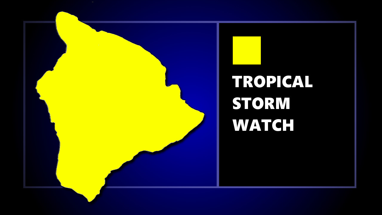
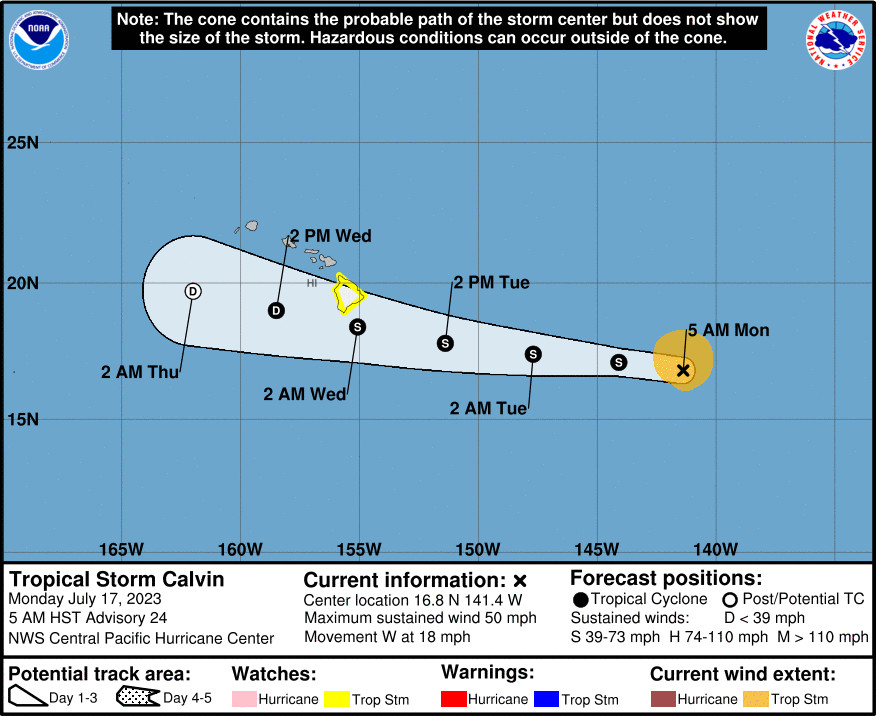
(BIVN) – A Tropical Storm Watch has been issued for Hawaiʻi island, as Tropical Storm Calvin is now in the Central Pacific, 920 miles east of Hilo as of 5 a.m. HST on Monday.
With maximum sustained winds near 50 mph, Calvin is moving west at 18 mph. The storm is on track to pass very close to the Big Island on Tuesday night and Wednesday, bringing a period of heavy rain, high surf and locally strong winds.
A Flood Watch has also been posted for Hawaiʻi island, from Tuesday evening through Wednesday afternoon.
The Hawaiʻi County Civil Defense issued an alert message on Monday morning, announcing the Tropical Storm Watch was in effect, and advising:
- Boat owners and those with shoreline property should begin preparing for possible surf impacts.
- Prepare your property for possible high surf, damaging winds, and flooding rains.
- Take this time to secure loose outdoor items prior to the onset of winds.
From the National Weather Service in Honolulu:
The center of Tropical Storm Calvin is forecast to pass over, or very close to, the Big Island of Hawaii from Tuesday night into Wednesday. Calvin is expected to weaken as it moves westward to the south of the other Hawaiian Islands Wednesday and Wednesday night, bringing the potential for some peripheral impacts.
Primary impacts are expected on the Big Island, where a period of heavy rainfall is expected, as well as high surf along east facing shores, and locally strong wind gusts.
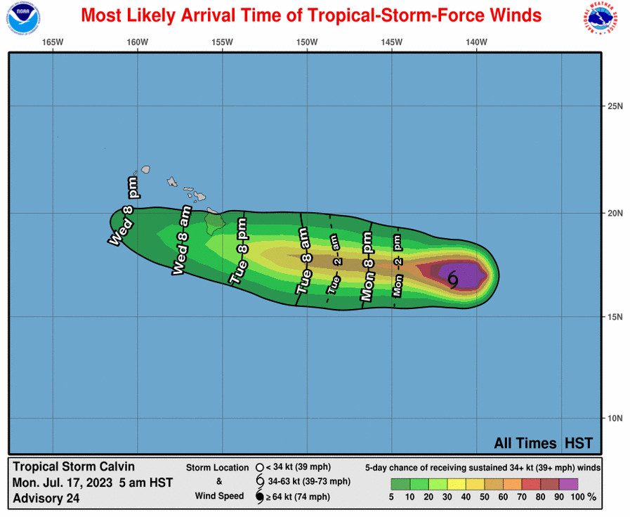
Flooding rain will be possible as early as Tuesday evening on the Big Island, and chances for heavy rain is expected to increase for much of the state Tuesday night and Wednesday. Expect storm total rainfall of 4 to 8 inches across mainly windward portions of the Big Island, with about 1 to 4 inches of rainfall elsewhere.
Coastal impacts associated with Calvin will include rapidly building surf Tuesday night through Wednesday. Surf heights will reach High Surf Advisory levels for most windward coasts, potentially reaching High Surf Warning levels (greater than 15 feet) along east facing shores of the Big Island. Although peak surf heights on the Big Island will likely occur around low tide Wednesday morning, some minor overwash and erosion is possible for exposed low-lying coastal areas.
Locally strong winds may begin as early as Tuesday evening across parts of the Big Island, with north winds shifting to the northeast and east as Calvin moves westward. Winds will primarily be northeasterly over the smaller islands, strongest Wednesday and Wednesday night. It is important to note that the mountainous terrain of the islands can produce localized areas of enhanced winds, even well away from the tropical cyclone center.
PRECAUTIONARY / PREPAREDNESS ACTIONS
Now is the time to check your emergency plan and emergency supplies kit and take necessary actions to protect your family and secure your home or business.
When making safety and preparedness decisions, do not focus on the exact forecast track since hazards such as flooding rain, damaging winds, large surf, storm surge, and tornadoes extend well away from the center of the storm.
POTENTIAL IMPACTS
* WIND:
Prepare for dangerous wind having possible significant imp acts across portions of the Big Island. Potential impacts in this area include:
Some damage to roofing and siding materials, along with damage to porches, awnings, carports, and sheds. A few buildings experiencing window, door, and garage door failures. Mobile homes damaged, especially if unanchored. Unsecured lightweight objects become dangerous projectiles.
Several large trees snapped or uprooted, but with greater numbers in places where trees are shallow rooted. Several fences and roadway signs blown over.
Some roads impassable from large debris, and more within urban or heavily wooded places. A few bridges, causeways, and access routes impassable.
Scattered power and communications outages, but more prevalent in areas with above ground lines.
Elsewhere across the Hawaiian islands, little to no impact is
anticipated.* SURGE:
Prepare for locally hazardous surge having possible limited impacts across portions of windward and southeast Big Island. Potential impacts in this area include:
Localized inundation with storm surge flooding mainly along immediate shorelines and in low-lying spots, or in areas farther inland near where higher surge waters move ashore.
Sections of near-shore roads and parking lots become overspread with surge water. Driving conditions dangerous in places where surge water covers the road.
Moderate beach erosion. Heavy surf also breaching dunes, mainly in usually vulnerable locations. Strong rip currents.
Minor to locally moderate damage to marinas, docks, boardwalks, and piers. A few small craft broken away from moorings.
Elsewhere across the Hawaiian islands, little to no impact is anticipated.
* FLOODING RAIN:
Prepare for dangerous rainfall flooding having possible significant impacts across mainly windward and southeastern portions of the Big Island. Potential impacts include:
Moderate rainfall flooding may prompt several evacuations and rescues.
Rivers and tributaries may quickly become swollen with swifter currents and overspill their banks in a few places, especially in usually vulnerable spots. Small streams, creeks, canals, arroyos, and ditches overflow.
Flood waters can enter some structures or weaken foundations. Several places may experience expanded areas of rapid inundation at underpasses, low-lying spots, and poor drainage areas. Some streets and parking lots take on moving water as storm drains and retention ponds overflow. Driving conditions become hazardous. Some road and bridge closures.
Prepare for locally hazardous rainfall flooding having possible limited impacts across other Hawaiian Islands from Kauai to Maui.
* TORNADOES:
Prepare for a tornado event having possible limited impacts across the Hawaiian islands. Potential impacts include:
The occurrence of isolated tornadoes can hinder the execution of emergency plans during tropical events.
A few places may experience tornado damage, along with power and communications disruptions.
Locations could realize roofs peeled off buildings, chimneys toppled, mobile homes pushed off foundations or overturned, large tree tops and branches snapped off, shallow-rooted trees knocked over, moving vehicles blown off roads, and small boats pulled from moorings.
PRECAUTIONARY/PREPAREDNESS ACTIONS
Now is the time to check your emergency plan and emergency supplies kit and take necessary actions to protect your family and secure your home or business.
When making safety and preparedness decisions, do not focus on the exact forecast track since hazards such as flooding rain, damaging wind gusts, storm surge, and tornadoes extend well away from the center of the storm.
The Central Pacific Hurricane Center provided this analysis of Tropical Storm Calvin in its 5 a.m. discussion:
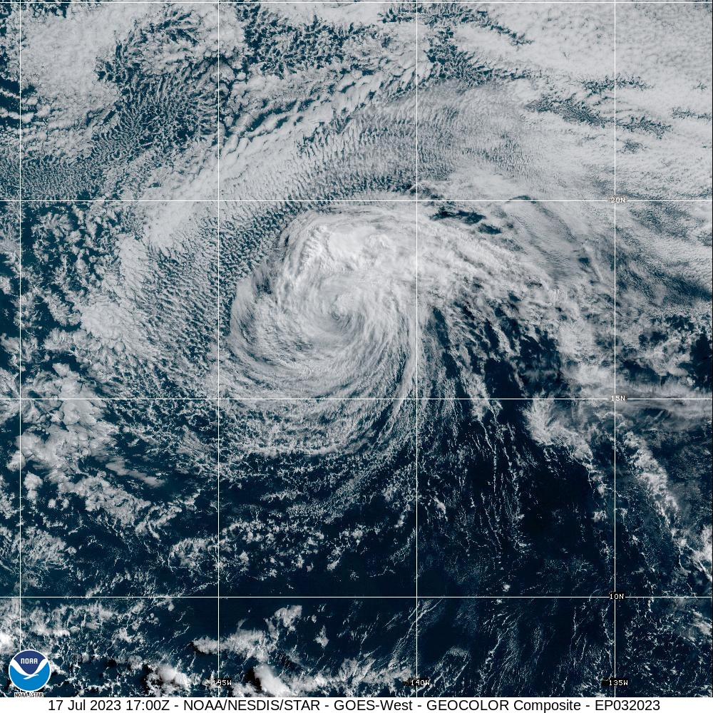
Conventional infrared satellite imagery shows that Tropical Storm Calvin’s low-level circulation center (LLCC) appears to be partially exposed early this morning. Therefore, the system has crossed longitude 140W into the Central Pacific Hurricane Center (CPHC’s) area of responsibility. Scatterometer passes from last evening showed a large swath of winds of 40-45 kt north of the LLCC. The subjective Dvorak satellite classification from PHFO is55 kt, SAB and JTWC are 35 kt, and TAFB’s final fix is 45 kt. Based on these observations, we are maintaining the current intensity at 45 kt for this advisory.
Calvin continues to move over cool SSTs of around 24 degrees C, and in a dry and stable environment. In the next 18-24 hours, the SSTs are expected to start gradually increasing as the cyclone begins to move closer to the main Hawaiian Islands. Southerly vertical wind shear will likely increase as Calvin nears the Big Island of Hawaii. This shear combined with entertainment of drier air into the system is expected to cause Calvin to weaken. This scenario would likely result in most of the deep convection (assuming it redevelops in the next day or two) being displaced to the north of the LLCC. The intensity forecast lies near the model consensus, and is similar to the previous official forecast we inherited from the National Hurricane Center (NHC) in Miami, Florida. Note that based on the recent scatterometer passes, we have expanded the wind radii in the northern semicircle.
The mid-level ridge to the north of Calvin will likely maintain a relatively rapid westward motion during the next few days. On this track, Calvin will likely move near or over the Big Island of Hawaii Tuesday night and Wednesday. It should then continue moving westward until it dissipates. The official forecast is near the previous NHC forecast, and lies close to the model consensus guidance.
KEY MESSAGES:
1. Calvin is forecast to pass very close to the Big Island Tuesday night and Wednesday, bringing a period of heavy rain, high surf and locally strong winds. Calvin is expected to weaken as it moves westward to the south of the other Hawaiian Islands Wednesday and Wednesday night, bringing the potential for some peripheral impacts.


by Big Island Video News7:33 am
on at
STORY SUMMARY
HAWAIʻI ISLAND - Calvin is forecast to pass very close to the Big Island Tuesday night and Wednesday, bringing a period of heavy rain, high surf and strong winds