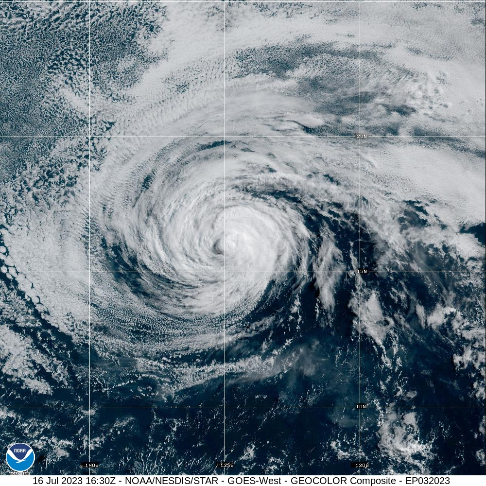
(BIVN) – Calvin weakened to a tropical storm overnight, as it maintains a forecasted track towards Hawaiʻi island.
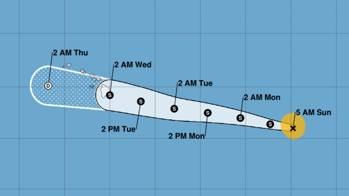
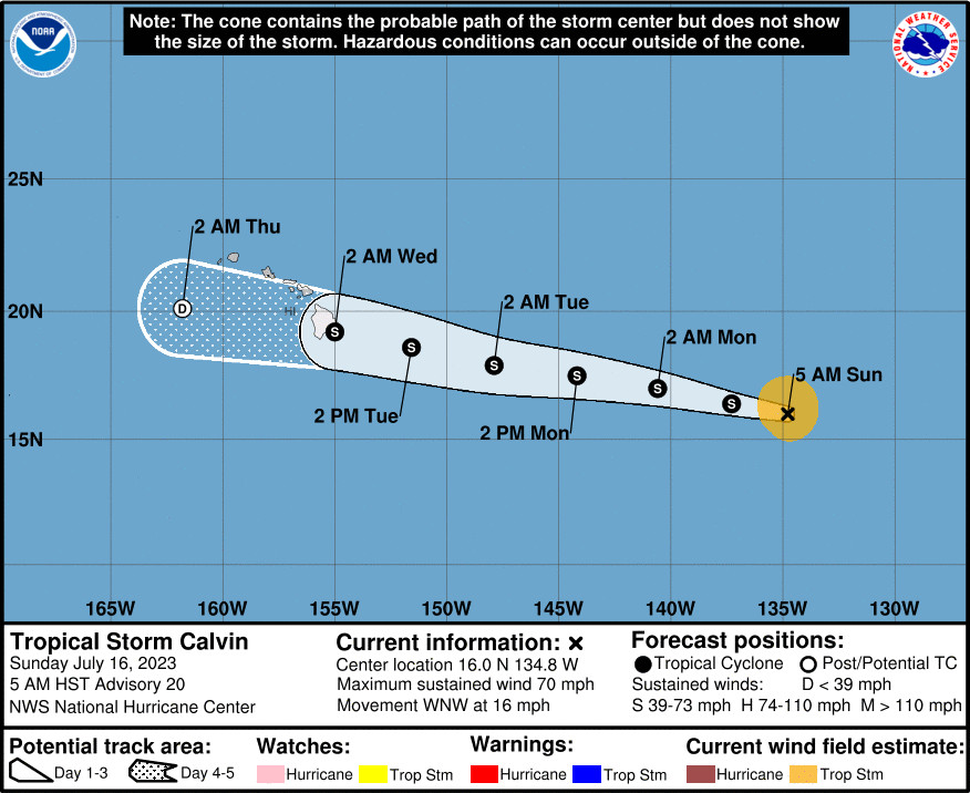
Tropical Storm Calvin was 1,360 miles east-southeast of Hilo as of 5 a.m. HST on Sunday morning, moving toward the west-northwest near 16 mph.
The National Weather Service in Honolulu says Tropical Storm Calvin is expected to “move close to, or over, the islands from Tuesday night through Wednesday night, bringing the potential for a period of locally strong winds, heavy rain, and high surf.”
The forecasters anticipate the likely the issuance of a Flood Watch as early as Sunday, as well as a possible Tropical Storm Watch. From the National Weather Service:
While it still remains too soon to nail down specific details as far as impacts on land, it is looking increasingly likely that at least portions of the state will see some impacts. The official forecast from the National Hurricane Center in Miami, Florida has been consistent in anticipating that the center of Calvin will move close to, or over, the Big Island Tuesday night and Wednesday, while producing tropical-storm-force winds in its northern semicircle. Some uncertainty continues to exist with respect to the track and intensity forecast, and it is also important to remember that impactful weather can occur well away from the center.
Calvin’s forward speed will be fairly quick when it is near the islands (toward the west at ~19 mph), so the amount of time any one island experiences gusty winds and heavy rainfall will be somewhat limited (probably on the order of 12-18 hours). However, the potential for extreme rainfall rates will likely warrant the issuance of a Flood Watch (FFAHFO), which is usually done with about a 48 hour lead time – which is also the desired lead time for a Tropical Storm Watch. Latest time-of-arrival graphical forecasts indicate that the earliest reasonable arrival time for tropical- storm-force winds on the Big Island is Tuesday afternoon, so these headlines could be issued for at least portions of the state later today or tonight.
“We’re still hopeful that Calvin won’t cause any major problems, but after three quiet hurricane seasons we don’t want people to be complacent about this hazard,” said James Barros, Administrator of the Hawai‘i Emergency Management Agency (HI-EMA), in a Saturday news release. Calvin was still a hurricane at that time. “Even if it weakens as expected, the storm still poses potential threats from heavy rain, high wind and coastal waves and rip currents,” Barros said. “Don’t be caught unprepared.”
From the National Hurricane Center discussion at 5 a.m. HST:
The cloud pattern of Calvin has further deteriorated this morning. The center is now exposed, and cloud tops have warmed over much of the circulation with only a small area of moderate to deep convection noted to the east of the center. The objective and subjective satellite intensity estimates continue to quickly decline, with a blend of the recent data suggesting that Calvin is no longer a hurricane. Based on these data and its poor satellite structure, the initial intensity is lowered to 60 kt.
The track forecast remains straightforward. Calvin is expected to keep moving generally westward for the next several days as it is steered by a well-established ridge over the eastern Pacific. This motion will bring the cyclone into the central Pacific basin (west of 140W) tonight or early Monday morning. Calvin is forecast to approach the Hawaiian Islands on Tuesday and pass near or over the Big Island of Hawaii early Wednesday. The track guidance remains in good agreement on this overall scenario, although the details of its track near Hawaii are still uncertain given the average amount of cross-track spread in the guidance. The latest NHC forecast is slightly faster and has been nudged slightly northward at 60-96 h, but still lies near the center of the guidance envelope and close to the HCCA and TVCE aids.
Calvin will move over 24 deg C waters and into a drier, more stable environment during the next couple of days. Therefore, continued weakening is anticipated, and the system could struggle to produce convection on its trek into the central Pacific basin. As Calvin moves closer to Hawaii, model-simulated satellite imagery suggests it could produce some renewed bursts of convection to the north of its center. This forecast keeps Calvin as a tropical cyclone through 72 h, although it could become post-tropical sooner if convection collapses for an extended period. Regardless, there is good support from both the global and hurricane models that Calvin will maintain some tropical-storm-force winds (mainly to the north of its center) as it nears Hawaii. With strong deep-layer southwesterly shear expected in 96-120 h, this forecast shows Calvin opening into a trough and dissipating by day 5.
KEY MESSAGES:
1. Calvin is forecast to move across the central Pacific Ocean and approach the Hawaiian Islands during the next few days. A Tropical Storm Watch could be issued for portions of the main Hawaiian Islands later today, and interests in Hawaii should closely monitor the latest forecast updates.


by Big Island Video News7:16 am
on at
STORY SUMMARY
HONOLULU, Hawaiʻi - Forecasters say a Tropical Storm Watch may be required for portions of the main Hawaiian Islands later today.