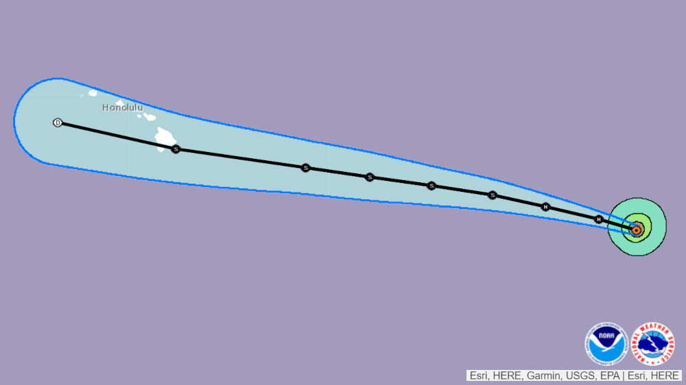
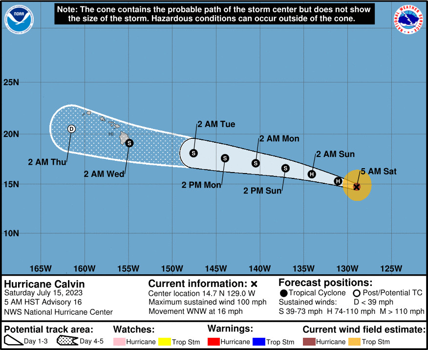
(BIVN) – Hurricane Calvin was 1,750 miles east-southeast of Hilo at 5 a.m. on Saturday morning, moving toward the west-northwest near 16 mph.
Calvin is no longer a major hurricane. With maximum sustained winds near 100 mph, Calvin is a Category 2 on the Saffir-Simpson Hurricane Wind Scale. Additional weakening is forecast through early next week.
“The guidance is reasonably well clustered on a track near or over the Big Island of Hawaii,” the National Hurricane Center wrote on Saturday morning, “but any potential impacts will be dictated by the track details that are still quite uncertain at this time.”
Calvin is expected to cross into the Central Pacific on Sunday night, and arrive close to, or over, the main Hawaiian Islands Tuesday night and Wednesday. “Some questions remain as to the intensity, but vertical wind shear is expected to increase as it nears the islands, with Calvin on a gradual weakening trend during its closest point of approach,” Honolulu forecasters with the National Weather Service wrote early Saturday morning. “Like most systems approaching Hawaii from the E, strongest winds are expected to be in the northern semicircle.”
The National Weather Service added:
Considering typical forecast track errors, it remains too soon to be specific as to where (and what – if any) impacts occur over land, which will be highly dependent on the track. If the center were to pass N of the islands, most of the strong winds would remain offshore, with a more southerly track potentially putting the islands in a stronger wind field. As a reminder, tropical cyclones can bring the triple threat of strong winds, heavy rainfall and high surf. The forward speed of the tropical cyclone (forecast to be near 18 mph) should preclude widespread flooding impacts for an extended period of time, hence we’ve decided that a Hydrologic Outlook (ESFHFO) is not warranted, although a Flash Flood Watch (FFAHFO) may be issued for parts (or all of) the state early next week.
Ocean swells generated by Calvin are expected to begin reaching the Hawaiian Islands early next week, and are likely to cause life-threatening surf and rip currents.
From the National Hurricane Center discussion at 5 a.m. HST:
The ragged eye of Calvin has been apparent at times in conventional satellite imagery this morning, but overall it has become less defined. Overnight GMI and more recent SSMIS passive microwave data show that some deep convection has eroded within the eastern portion of the eyewall. The vortex also appears somewhat tilted with height, as the 37 GHz low-level center was displaced a bit to the south of the 89 GHz mid-level one. A blend of the latest objective UW-CIMSS satellite estimates and subjective Dvorak classifications from TAFB and SAB support an initial intensity of 85 kt.
The weakening trend that began last night is expected to continue for the next several days due to Calvin moving over cooler waters and into a drier and more stable environment. Also, southwesterly deep-layer shear is forecast to increase from 60-120 h as the cyclone traverses the central Pacific. This will adversely affect its ability to sustain organized convection, although to what extent is still somewhat uncertain. Regardless of its tropical or post-tropical status, Calvin appears likely to maintain some tropical-storm-force winds in the northern portion of its circulation through 96 h. Overall, few changes were made to the updated NHC intensity forecast, which closely follows the multi-model HCCA and IVCN aids. The global model fields suggest the system could open up into a trough soon after day 5.
Calvin is moving quickly west-northwestward at 285/14 kt. With a well-established mid-level ridge over the eastern Pacific, this general motion is expected to continue through the forecast period. This course brings Calvin into the central Pacific basin (west of 140W) by Monday morning and toward the Hawaiian Islands on Tuesday and Wednesday. The guidance is reasonably well clustered on a track near or over the Big Island of Hawaii, but any potential impacts will be dictated by the track details that are still quite uncertain at this time. The updated NHC track forecast is a bit faster and slightly south of the previous one at days 3-5, in agreement with the latest consensus aids and near the center of the guidance envelope.
KEY MESSAGES:
1. Calvin is forecast to move across the central Pacific Ocean and approach the Hawaiian Islands early next week. It is too early to determine the exact location and magnitude of potential impacts given uncertainties in the track, intensity, and structure of Calvin as it approaches the islands. Interests in Hawaii should closely monitor the latest forecast updates.


by Big Island Video News8:13 am
on at
STORY SUMMARY
HAWAIʻI ISLAND - Potential impacts to Hawaiʻi from the storm will depend on details that forecasters say are still uncertain at this time.