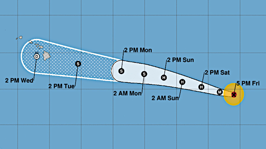
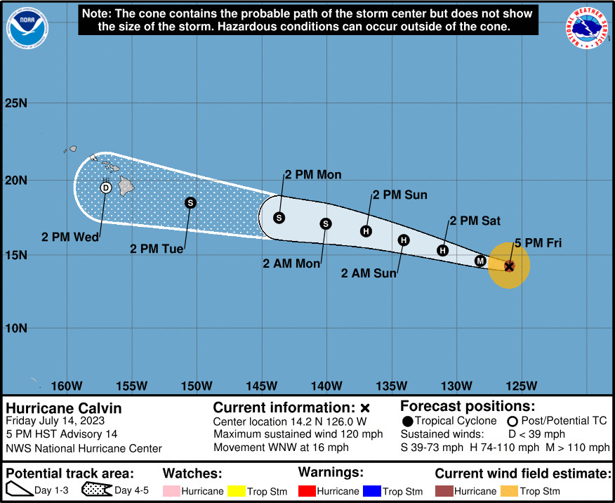
(BIVN) – Hawaiʻi island officials are preparing residents for the potential impacts of Calvin, a category 3 hurricane as of 5 p.m. on Friday, expected to near Hawaiʻi in a weakened state early next week.
Calvin or its remnants could bring impacts to the Big Island “as early as Tuesday but most likely late Tuesday into Wednesday,” the National Weather Service says. “Although it remains too early for many specifics at this time, interests are encouraged to continue monitoring the forecast as details become more clear over the next few days.”
The Honolulu-based forecasters wrote Friday afternoon that “it is possible that at least portions of the state could receive strong winds, heavy rain, and/or high surf”.
Swells generated by Calvin are expected to reach the Hawaiian Islands early next week.
In addition to the first Hawaiʻi County Civil Defense message concerning Calvin issued Friday afternoon, officials shared this news release:
Hawaiʻi County is closely monitoring the progress of Hurricane Calvin as it approaches the Central Pacific region.
While current forecasts suggest that Hurricane Calvin may weaken below hurricane levels before reaching Hawaiʻi, County officials maintain that it is essential for residents to remain vigilant and prepared for potential hazards. The County emphasizes the importance of recognizing the potential impacts, which include flooding rains, high surf, and high winds that can affect the islands.
As part of the County’s commitment to public safety, we urge all residents to be proactive and take appropriate preventive measures to safeguard themselves and their property before conditions become hazardous. Residents can stay informed about the latest updates by following guidance from public messaging channels. For the most reliable information, we encourage everyone to regularly check the Civil Defense webpage.
To ensure timely and critical alerts, the County encourages residents to sign up for Everbridge messages from Civil Defense. By doing so, residents will receive important notifications directly to their preferred communication channels, allowing them to stay informed and make informed decisions.
As we continue to monitor Hurricane Calvin’s progress, the County will provide regular updates to keep residents informed and prepared for any potential impacts. We urge everyone to stay tuned to public messaging for the latest information and to take necessary precautions to ensure their safety.
From the National Hurricane Center at 5 p.m. HST:
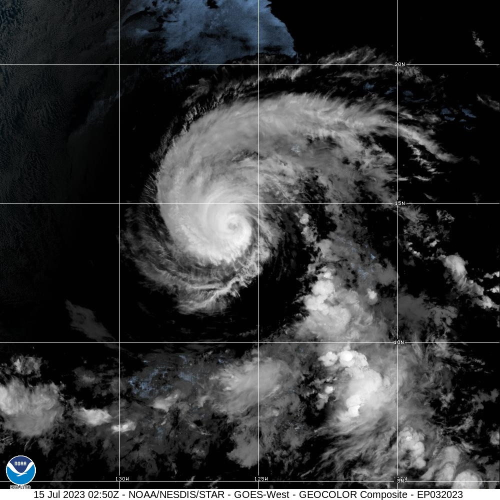
Calvin has become a bit less organized since the last advisory, with the eye becoming less distinct in satellite imagery and the cloud tops in the eyewall becoming warmer. This is likely due to a combination of the hurricane passing over the 26C sea surface temperature isotherm and hints of an outer eyewall seen in a 0023 UTC SSM/IS overpass. Various subjective and objective satellite intensity estimates are in the 100-115 kt range, and based on the current trends in satellite imagery the initial intensity is reduced to 105 kt.
Calvin has likely peaked in intensity, and it should weaken steadily during the next 48 hours as sea surface temperatures under the forecast track decrease to near 24C. The intensity forecast is less clear cut after 48 h. While the consensus of the guidance indicates that Calvin should continue to weaken due to increasing southwesterly vertical shear and dry air entrainment, the sea surface temperatures along the forecast track increase from 48 to 120 h. Thus, it cannot be ruled out that the cyclone will weaken more slowly than currently forecast in the later part of the forecast period. Overall, the new intensity forecast follows the trend of the intensity guidance and has only minor adjustments from the previous forecast.
The initial motion remains 285/14 kt, and this general motion should continue for the next several days as Calvin is steered by a low- to mid-level ridge that extends westward across the eastern subtropical Pacific. There has been little change in the track guidance since the previous advisory. Thus, the new forecast track is similar to the previous track and lies near the various consensus models. Calvin is still expected to cross 140W and move into the central Pacific basin by early Monday morning, then approach the Hawaiian Islands on Tuesday and Wednesday.
KEY MESSAGES:
1. Calvin is forecast to move across the central Pacific Ocean and approach the Hawaiian Islands early next week. It is too early to determine the exact location and magnitude of potential impacts given uncertainties in the track, intensity, and structure of Calvin as it approaches the islands. Interests in Hawaii should closely monitor the latest forecast updates.


by Big Island Video News6:22 pm
on at
STORY SUMMARY
HAWAIʻI ISLAND - The National Hurricane Center says Hurricane Calvin has already weakened slightly as the storm moves west-northwest in the Eastern Pacific.