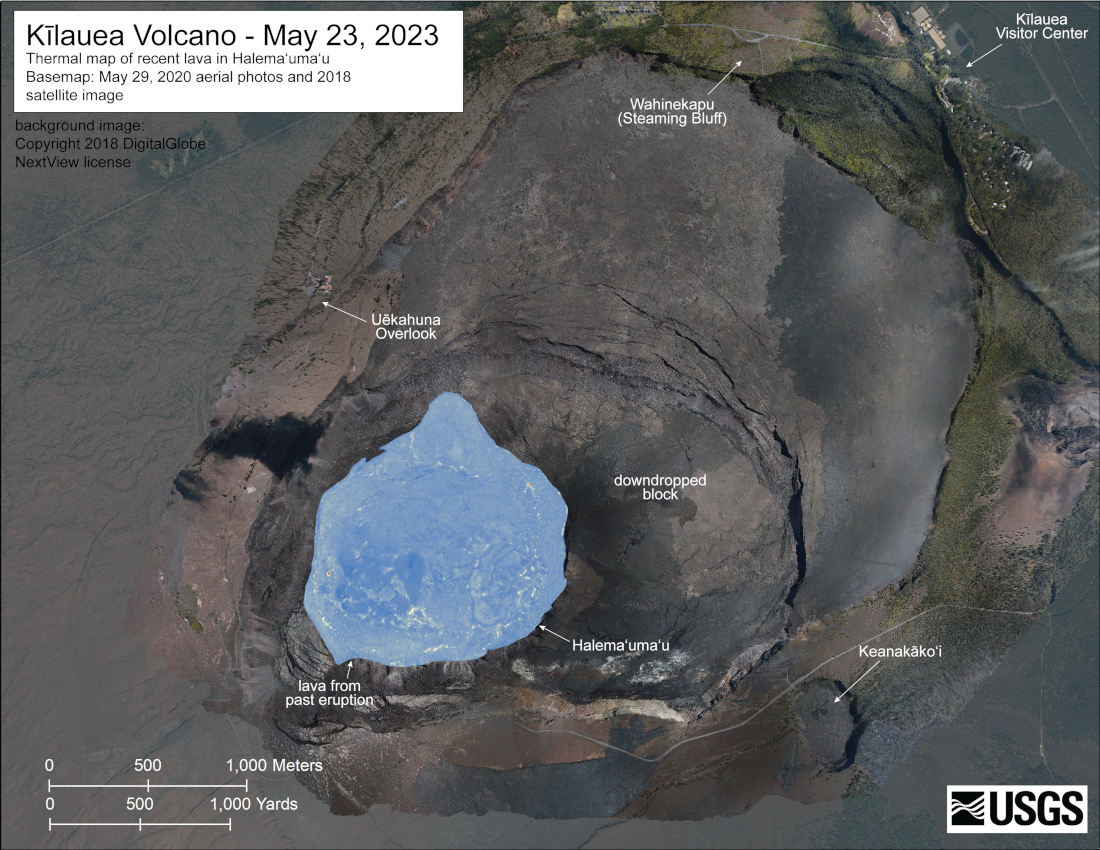
USGS: “A helicopter overflight on May 23, 2023, allowed for aerial visual and thermal imagery to be collected of Halema‘uma‘u crater at the summit of Kīlauea. No active lava was present in the crater, with only scattered warm spots on the crater floor. The scale of the thermal map ranges from blue to red, with blue colors indicative of cooler temperatures and red colors indicative of warmer temperatures.”
(BIVN) – Kīlauea volcano is not erupting, however the summit is currently exhibiting signs of heightened unrest.
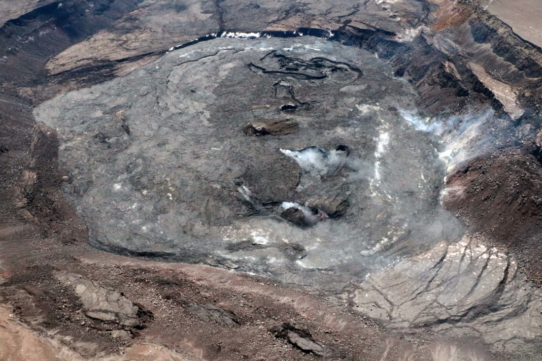
The USGS Hawaiian Volcano Observatory recently gathered new imagery of the summit area during a routine monitoring overflight, and posted the photos to its website. A new thermal map was also produced using the data gathered during the flight.
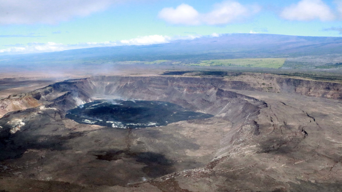
USGS: “This aerial view, looking east across Halema‘uma‘u crater floor, shows the complex features formed during recent Kīlauea summit eruptions. The basin of the lava lake from the September 2021-December 2022 eruption is visibly steaming near the base of the photo, the island that formed during the December 2020-May 2021 eruption is brown-colored and visible in the center of the photo, and the basin that formed during the most recent January-March 2023 eruption is the complex basin-feature visible near the top of the image.” (USGS image by K. Mulliken)
From the USGS Hawaiian Volcano Observatory on Wednesday:
Activity Summary: Kīlauea volcano is not erupting. Kīlauea summit is currently exhibiting signs of heightened unrest. Summit seismicity remains elevated. No unusual activity has been noted along Kīlauea’s East Rift Zone or Southwest Rift Zone.
Halemaʻumaʻu Lava Lake Observations: No active lava has been observed over the past day. A live-stream video of the crater is available at (YouTube).
Summit Observations: Over the past day, summit tiltmeters recorded little change in tilt, potentially indicating a short pause in deformation. However, earthquake rates remain elevated beneath Kīlauea summit and Nāmakanipaio, with 73 events over the past day. Overall, both deformation and seismicity rates have been high; elevated beyond the rates observed preceding the January 5, 2023 summit eruption. Most of the earthquakes have been smaller than magnitude-2 and not reported felt. The most recent sulfur dioxide (SO2) emission rate of approximately 151 tonnes per day was measured on May 16, 2023.
Rift Zone Observations: No unusual activity has been noted along the East Rift Zone or Southwest Rift Zone; steady rates of ground deformation and seismicity continue along both. Measurements from continuous gas monitoring stations in the middle East Rift Zone—the site of 1983–2018 eruptive activity—remain below detection limits for SO2.
This story appears in the above BIVN Update. The video will jump to the associated story when played. (A synthesized voice was utilized in the narration for this story)

by Big Island Video News
on at
STORY SUMMARY
HAWAIʻI VOLCANOES NATIONAL PARK - Scientists captured new images of Kīlauea during an overflight on the morning of May 23, as the volcano shows signs of heightened unrest.