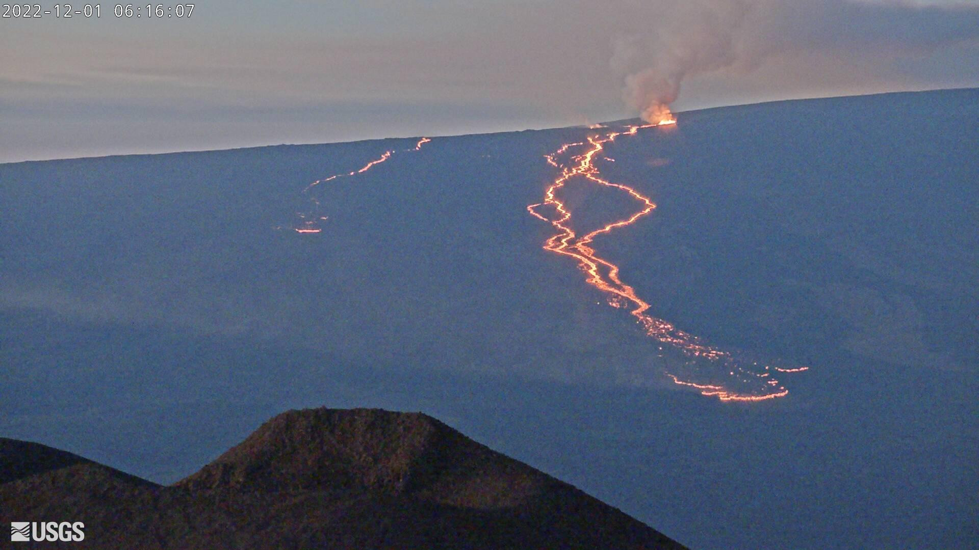
USGS webcam image taken Thursday morning showing the eruptions on Mauna Loa’s Northeast Rift Zone, as seen from Mauna Kea
UPDATE – (7:30 a.m. HST on Thursday, December 1)
- There are two active lava flows on the Northeast Rift Zone of Mauna Loa Volcano. The USGS Hawaiian Volcano Observatory reports the leading edge of the flow closest to Daniel K. Inouye Highway “had minimal movement and remains near the 7,000 foot elevation and more than 3 miles from the highway.”
- Emergency officials say there will be a monthly outdoor warning siren test this morning at 11:45 a.m. “We contacted our Hawai‘i County partners to see whether they were concerned that the test might confuse the public,” said Luke Myers, Hawai‘i Emergency Management Agency administrator. “But they made it clear they thought the test should go on this week to protect against future threats.”
(BIVN) – Emergency officials spent Wednesday keeping a close eye on the ongoing eruption of Mauna Loa, tracking the lava flows that are being produced by two active fissures on the Northeast Rift Zone.
Fissure 3 is the dominant source, and is sending the largest flows to the north, down the mountain-side, and in the direction of Hawaiʻi island’s cross-island highway. The advance of the flow front slowed on Wednesday morning, and by noon it was moving north at a rate of 0.02 miles, or 24 meters, per hour.
Fissure 4 is still active Wednesday, with flows moving toward the northeast. Officials say a small lobe of lava is moving to the east at a slower rate.
Monitors detect volcanic tremor in the location of the currently active fissures. Scientists say this indicates that magma is still being supplied, and activity is likely to erupt as long as the tremor signal continues.

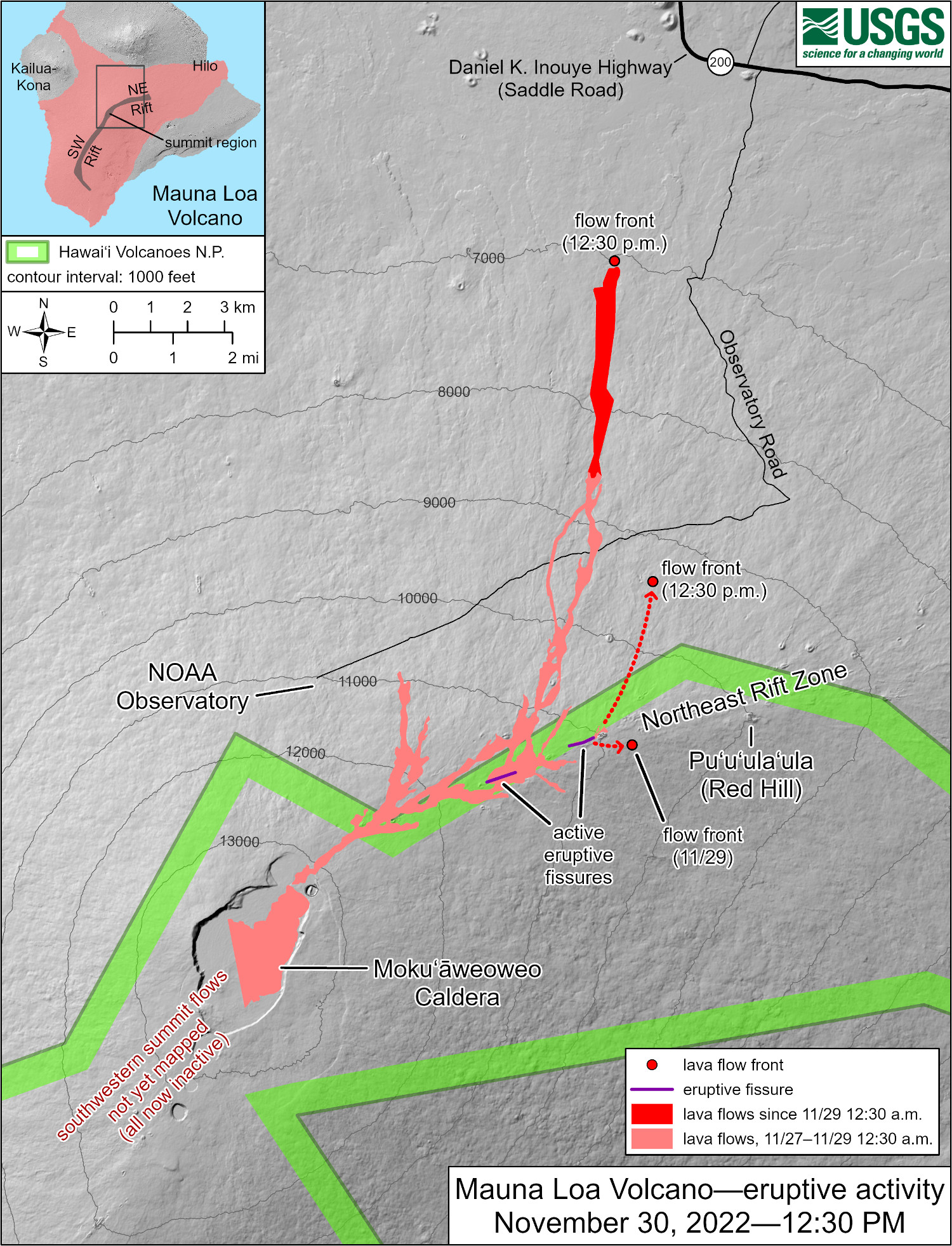
USGS: “The Northeast Rift Zone eruption of Mauna Loa has continued into its third full day. At this time two fissures are active, sending lava flows primarily to the north-northeast. Webcam and satellite views overnight allowed USGS analysts to accurately map some of the most active flows, displayed in red here, along with older flows further uprift and in part of Mokuʻāweoweo Caldera. Elsewhere the progression of the flows is marked by dashed lines and points for the flow fronts, mapped by HVO field crews. As of 12:30 p.m. today, the most downslope flow is within 4 miles (6 kilometers) of the Daniel K. Inouye Highway (Saddle Road).”
New maps published Wednesday afternoon by the US Geological Survey’s Hawaiian Volcano Observatory show path of the flow into the Saddle Road area. The last official measurement placed the lava about 3.6 miles, or 5.8 kilometers, from the Daniel K. Inouye Highway.
Meanwhile, a new emergency rule was enacted on Wednesday in a continuing effort to crack down on parking and walking along the Highway, where residents and visitors are gathering for an evening view of the eruption.
A previous Emergency Rule signed by Hawaiʻi County Mayor Mitch Roth established no parking zones between mile marker 16 and mile marker 31. The new Emergency Rule #2 extends the prohibition area from mile marker 16 all the way to the Highway 190 intersection on the Kona side of the Saddle. Officials report several accidents along the highway with the high volume of motorists driving up to take a look.
Now that the lava flow has reached a flat area, it is beginning to slow down, spread out and inflate. Forecasts indicate it may take two days or more before lava flows reach the highway. Once the Saddle Road is gone, a critical cross-island corridor will be lost.
During a Wednesday media call, the idea of lava diversion was discussed.
“We were having that discussion this morning,” said Talmadge Magno, the Hawaiʻi County Civil Defense administrator. “Nothing solid came out of it. We’ll continue to have that discussion, but at this time no plans.”
“It’s a volume problem,” added Ken Hon, the scientist-in-charge of the USGS Hawaiian Volcano Observatory. “You’re going to store up a certain amount of lava somehow. The places that have had some successes – mainly in Italy, where they’ve done a fair amount of work on this – you need a very geographically constricted area if you’re going to dam the lava up. But it’s just like damming water. They were able to successfully dam it up for a few months, but eventually it overflowed the dams.”
“The other way is to try and get it to stay near the source and distribute itself,” Hon continued, “but nobody’s really had a lot of success with that. Breaking down the ʻaʻā channels is extremely difficult to do. They’ve had some luck doing that. Bombing, to date, has really had very little impact particularly on flows like the ones we’re seeing today.”
“And then there’s a lot of issues here, as well, with what’s an appropriate thing to do. Or not an appropriate thing to do so,” Hon said. “It’s a very difficult process, at any rate, especially with high volume flows like this.”


by Big Island Video News6:39 am
on at
STORY SUMMARY
HAWAIʻI ISLAND - New maps published Wednesday afternoon show the path of the flow into the Saddle Road area, placing the lava about 3.6 miles, or 5.8 km, from the Daniel K. Inouye Highway.