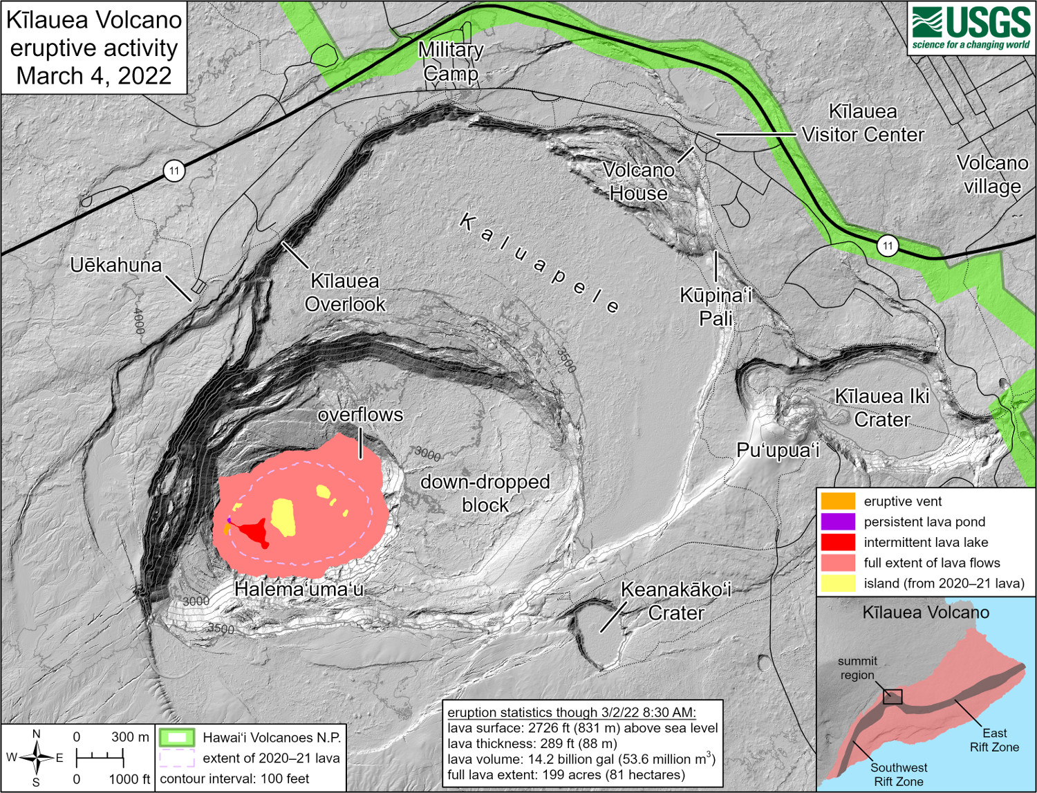
USGS: “This reference map depicts the ongoing Kīlauea summit eruption on March 4, 2022. One eruptive vent is intermittently active within Halema‘uma‘u, in the western end of the crater. When this vent is effusing lava, it pours into a lava lake, colored red on this map. During eruptive pauses, the only active lava is within a pond just north of the vent, colored dark purple on this map. The eruption statistics provided here are current as of the last HVO overflight on March 2, 2022; the volume-averaged surface of the whole lava lake was approximately 2,726 ft (831 m) above sea level at that time. When the eruption is vigorous, lava is visible from three public visitor overlooks in Hawai‘i Volcanoes National Park: Keanakāko‘i Overlook and KUPINAI Pali (Waldron Ledge) can see the eruptive vent and lava lake, while Kīlauea Overlook can occasionally see lava ooze-outs in the southeast part of the crater.”
(BIVN) – The eruptive activity at the summit of Kīlauea volcano remains steady, with no indications of activity migrating elsewhere on Kīlauea.
Kīlauea has not undergone an activity start-and-stop cycle in a few days. From today’s update from the USGS Hawaiian Volcano Observatory:
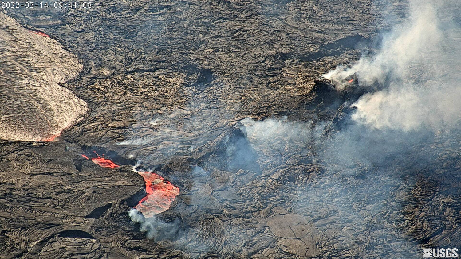
Halemaʻumaʻu Lava Lake Observations: Eruption of lava from the western vent into the active lava lake surface (approximately 2.5% of Halemaʻumaʻu crater floor) continued through yesterday. The active western lava lake surface of Halema‘uma‘u crater has remained at a steady elevation over the past 24 hours, corresponding with continued slightly inflationary tilt for the past day. Minor and slow crustal overturning occurred on the northwest side of the crater floor edge throughout the day and also began on the southeast side of the crater floor edge, lasting for several hours yesterday afternoon. The highest point on the Halemaʻumaʻu crater floor has risen approximately 97 meters (318 feet) since the eruption began on September 29, 2021. The erupted volume is 45 million cubic meters (59 million cubic yards) of lava as measured on January 25, 2021.
Summit Observations: Summit tilt yesterday continued a slightly inflationary trend through yesterday. Seismic data shows that the volcanic tremor is still elevated this morning and earthquake activity at the summit remains below background levels. A sulfur dioxide (SO2) emission rate of approximately 1900 tonnes per day (t/d) was measured on March 10.
Rift Zone Observations: No unusual activity has been noted along the East Rift Zone or Southwest Rift Zone; low rates of ground deformation and seismicity continue along both. Measurements from continuous gas monitoring stations downwind of Puʻuʻōʻō in the middle East Rift Zone remain below detection limits for SO2, indicating that SO2 emissions from Puʻuʻōʻō are negligible.
Kilauea remains at a USGS Alert Level of WATCH. Scientists issue a brief eruption “Status Report” around 3 p.m. HST.

by Big Island Video News
on at
STORY SUMMARY
HAWAIʻI VOLCANOES NATIONAL PARK - All recent volcanic activity has been confined to the smaller active lake within Halemaʻumaʻu crater.