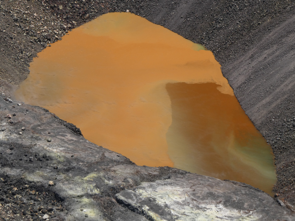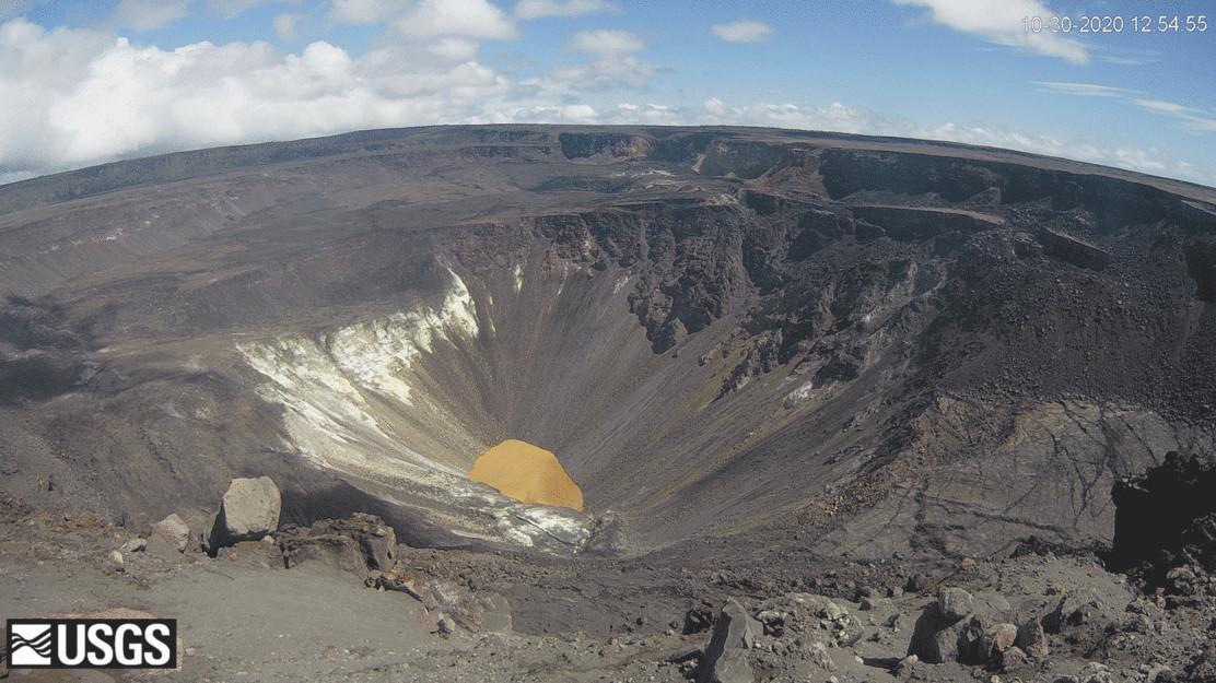
The colorful caldera lake at Kīlauea summit. The view is from the western rim of Halema‘uma‘u crater, 1900 ft (580 m) above the water surface, in a restricted area of Hawai‘i Volcanoes National Park. USGS photo by M. Patrick 08/25/2020.
(BIVN) – Kīlauea is not erupting, and scientists continue to keep a close on the volcano, watching for any signs of unrest.
“Sulfur dioxide emission rates are low at the summit, consistent with no significant shallowing of magma,” the most recent Kīlauea activity reports states. “Some amount of sulfur dioxide is being dissolved into shallow groundwater and the crater lake at the bottom of Halema‘uma‘u; work continues to try and quantify this process. As of November 3rd, the lake depth was approximately 48 meters or 157 feet.”
This week’s Volcano Watch article, written by U.S. Geological Survey Hawaiian Volcano Observatory scientists and affiliates, goes into greater detail about the monitoring of the Kīlauea summit area. Today’s article is by HVO technician Frank Younger:
Famous for glowing red lava and billowing volcanic plumes, Halema‘uma‘u has long inspired poets, painters and photographers to find meaning in the color and light of this dynamic landscape.
Today, Kīlauea’s current phase of activity has inspired volcanologists to experiment with cutting edge techniques to understand the dynamic colors and patterns of Halema‘uma‘u’s newest feature: a steaming hot water lake.
For fifteen months now, hot groundwater has been seeping into the collapse pit created by the evacuation of the 2008–2018 Halema‘uma‘u lava lake and part of the underlying summit magma chamber. Since the gaping pit and the water lake rising within are physically inaccessible, the USGS Hawaiian Volcano Observatory (HVO) uses remote techniques to monitor this changing, and potentially hazardous, environment.
HVO uses Unoccupied Aircraft Systems (UAS, or ‘drones’) to collect water samples, the chemical analyses of which are snapshots of lake composition. Visual and thermal cameras keep constant watch on the lake surface and the hot fumaroles surrounding it. LiDAR (Light Detection and Ranging) helps to reveal the lake’s growing form. A Digital Elevation Model (DEM) is integrated with frequent water level measurements to calculate lake depth, volume, and inflow rate. These quantitative data sets are complemented by the written accounts of HVO scientists, who document their first-hand observations in field logs.
The lake gives strong impressions of color, pattern, and motion. When it first emerged, it was described as a pond of milky turquoise water. Later, it developed yellow hues and green shoreline margins. Today, the lake surface has lobes of rust orange water over expanses of deep brown, with patches of light brown and tan. Elongated green inflows emerge from the rocky shoreline, along which several ruddy spots have recently upwelled.
The water surface is a mosaic in constant motion, a scene that changes by the minute and hour. Sharply defined color boundaries are often seen, accompanied by more subtle gradients and mixing. The patchwork waters may indicate zones of distinct temperature and dissolved constituents, and their movement is likely driven by differentials of density, wind, and fresh groundwater inflow.
As HVO scientists documented the lake’s early growth and development, they recognized the need to define these valuable visual observations of color with quantitative measurements, and to help control for variable effects of lighting, personal impressions, and the color biases in cameras.
A colorimeter instrument, a handheld optical device that measures chromaticity and brightness, is being field tested for this purpose. A similar type of color measurement was conducted at Aso Volcano in Japan in 2010, inspiring the techniques used by HVO. In an experiment to test its efficacy at Kīlauea, HVO scientists use a portable colorimeter to quantify visual observations and track color changes over time.
Colorimeters are more commonly used in industries like food processing and textile manufacturing than in volcanology. Colorimetry is the measurement of the wavelength and intensity of light. The quantification of color can be divided in two parts. Brightness, or luminicity, is the quantity of light that is reflected, emitted from, or passes through an object. Chromaticity is a measurement of hue and colorfulness, independent of brightness. Colorimetry relates these variables to the human eye’s sensation of color, and to our judgement of the physical stimulus of light.
In the field, scientists make broad visual observations, then sight the colorimeter at a point of interest. The record of chromaticity and brightness builds upon hydrologic and geologic data sets, contributing insight that may help link other remote observations. Analysis of the colorimetry data from this experimental technique may help scientists explain the dynamic colors seen at the Halema‘uma‘u lake.
Lake color changes may possibly even signal changing volcanic conditions beneath the watery depths. Water color and appearance changes have been observed at other active crater lakes around the world. For example, at Aso Volcano in Japan in 2003, Yudamari lake changed from blue green to solid green before an eruption occurred at the lake bottom.
While we don’t know if the water lake within Halema‘uma‘u would have a similar color change prior to an eruption, it is a potential indicator that HVO scientists will be looking for and tracking as part of routine monitoring in the post-2018 collapse era of Kīlauea activity.


by Big Island Video News8:28 am
on at
STORY SUMMARY
HAWAIʻI VOLCANOES NATIONAL PARK - This week, the USGS Hawaiian Volcano Observatory talks about the innovative techniques used to monitor the crater lake in Halemaʻumaʻu.