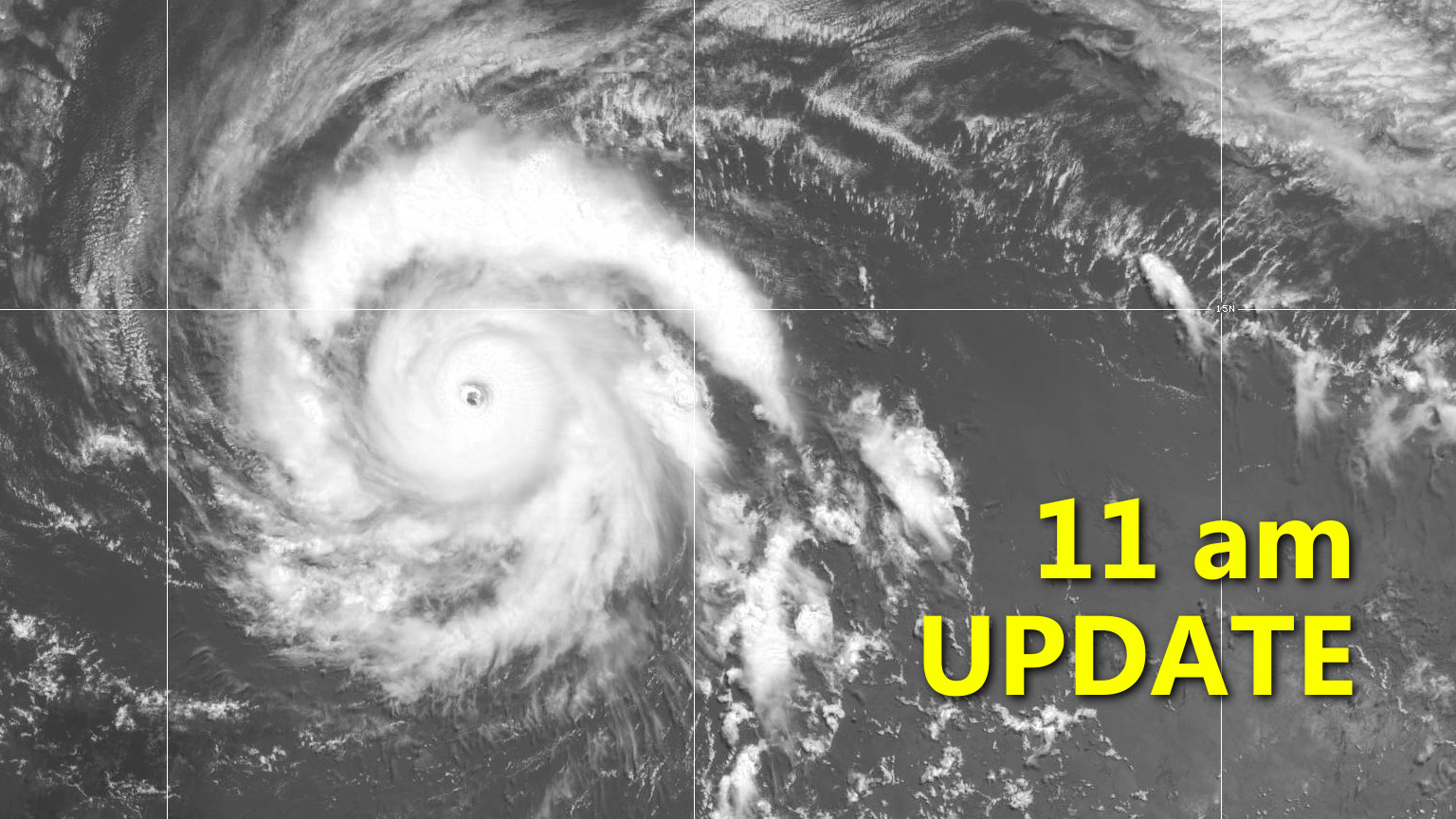
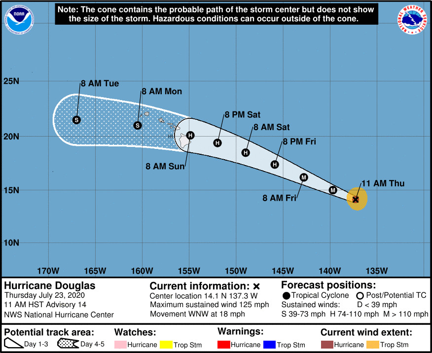
(BIVN) – Hurricane Douglas is 1,235 miles east southeast of Hilo, and is gaining strength as it approaches the Central Pacific.
The storm’s maximum sustained winds have increased to near 125 mph with higher gusts, making Douglas a category 3 hurricane on the Saffir-Simpson Hurricane Wind Scale.
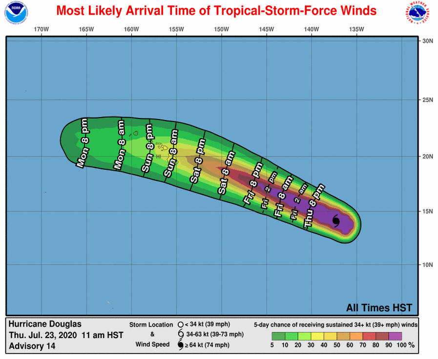
There are no coastal watches or warnings in effect for Hawaiʻi, however the National Hurricane Center says interests in the Hawaiian Islands should monitor the progress of Douglas, adding that “watches could be issued on Friday for a portion of the area.”
“Douglas is expected to move near or over portions of the Hawaiian Islands this weekend,” the National Hurricane Center says, “and there is an increasing chance that strong winds, dangerous surf, and heavy rainfall could affect portions of the state beginning on Sunday.” From the 11 a.m. discussion:
Visible satellite images show that Douglas is quite a powerful hurricane. The eye has become more crisp during the day, and infrared data also show that the eyewall convection has deepened. The initial wind speed is raised to 110 kt, which matches a blend of the latest TAFB/SAB Dvorak estimates. Douglas is beginning to move across the typical cool SST gradient of the eastern Pacific, implying that the hurricane is probably near its peak intensity. The cyclone should only slowly weaken on Friday and Saturday due to cooler waters along the predicted track and the vertical shear remaining low. As the hurricane approaches the Hawaiian Islands on Sunday, the SSTs increase but so does the shear. Since the shear generally dominates over marginally warm waters, a continued weakening is forecast. However, almost all of the guidance shows Douglas near hurricane strength as it moves close to Hawaii. The model guidance remains consistent, and no significant changes were made to the NHC wind speed prediction.
Douglas continues moving fairly quickly toward the west-northwest. A large mid-level ridge over the eastern and central Pacific should continue to steer the hurricane on this general course and speed for the next couple of days, with some deceleration and a westward turn by late in the weekend. The guidance is a little more divergent than the previous cycle, with a subtle northward model trend at longer range due to a weaker ridge forecast north of Hawaii, though the ECMWF and its ensembles have shifted a little southward. Given these mixed signals in the guidance, very little change is made to the previous NHC track forecast, and the new official forecast lies on the southwest side of the model envelope.
With Hurricane Douglas approaching, government agencies and critical utilities are beginning to issue messaging. The State of Hawaiʻi DOT issued this media release:
The Hawaii Department of Transportation (HDOT) encourages travelers to stay informed as Hurricane Douglas approaches the state. Residents and visitors should continue to monitor current conditions through updates from the National Weather Service and media outlets.
HDOT is in communication with Federal, State, and County officials to coordinate preparation for the potential effects of Douglas. Updates on any actions or closures for airports, harbors, or highways related to severe weather will be posted on the HDOT website… and social media accounts [Facebook] and [Twitter].
As a reminder, storm readiness actions and traveler tips for airports, harbors, and highways are:
Airports
In general, State of Hawaii airports will remain open during weather events unless there is damage to the runway or terminal facilities; however, the Ellison Onizuka International Airport at Keahole may restrict passenger boarding and deplaning during high winds or heavy rains. Airport managers have required emergency preparedness measures and will adjust their readiness posture should storm conditions develop in their area.
Air travelers with confirmed tickets for travel into or out of Hawaii airports are encouraged to check with their airline for potential flight delays, cancellations, or travel waivers.
Harbors
HDOT Harbors Division coordinates with the United States Coast Guard (USCG) regarding port readiness for heavy weather events. The USCG Captain of the Port sets port condition protocols (i.e., Whiskey, X-Ray, Yankee, and Zulu) based on changing weather conditions prior to storm impacts. Commercial ports for Maui and Hawaii County were set at Port Condition Whiskey as of 8 a.m., Thursday, July 23.
Commercial vessels requesting to remain or enter the port are required to submit their mooring plans to the USCG and to the respective commercial harbor master with HDOT Harbors. The Harbor Master Notice providing instructions and forms can be obtained [here].
With over 98-percent of all imported goods being shipped through Hawaii’s ports, all ports will remain open and operational for as long as safely possible ahead of a storm making landfall to ensure the greatest amount of delivery of goods to the community.
Highways
HDOT Highways Division prestaging procedures include checking drainage systems along state routes to ensure they are clear prior to rain impacts; notifying crews of possible emergency call outs and procedures; securing of state base yards; and, topping off equipment and generators. Notification is also made to contractors working on state highways to prepare to remove BMPs and secure work areas.
The Hawaiʻi DOT also offered this advice for motorists:
- Keep your gas tank at least half-full in case you need to evacuate or move to higher ground.
- Make sure your windshield wipers are in good condition and use your headlights if you are driving in rainy conditions. Turning on your headlights increases your visibility and helps make other drivers aware of you.
- Do not drive through fast moving water or water of indeterminable depth. You could stall out your car or your vehicle could be washed away. As little as 24-inches of moving water could possibly wash away a vehicle.
- Do not drive in high winds, especially in high profile vehicles as you risk your vehicle being pushed by winds or rolled over.
- After a hurricane or wind event, be cautious on the road as debris and live electrical lines could cause damage to you and your vehicle. Do not ever try to move a downed line yourself.
Hawaiian Electric issued a news release saying that the utility is closely monitoring Hurricane Douglas’ movement to move crews and equipment to areas most likely to be affected. “Forecasts show that wind and heavy rain could reach Hawai‘i Island on Sunday morning,” the company said. “Impacts to the other islands are expected as early as Sunday afternoon. Customers should review family and business emergency plans, ensure they have supplies they need on hand, and keep close watch on the development of the storm system.”
As the storm approaches, consider the following:
- Unplug electric appliances you may not need or use until the storm has passed or until power is restored
- Check emergency equipment such as flashlights, emergency generators, battery-operated (hand-crank or solar) radios, light sticks, and lanterns to be sure they are operational and buy extra batteries
- Stock up on non-perishable foods, medications, personal hygiene, sanitary and baby supplies to last 14 days
- Keep a first aid kit and special medications
- Pack COVID-19 safety supplies like face cloth coverings, disinfecting supplies, and hand sanitizers in case you need to evacuate
- Pack a manual can opener and bottle opener
- Turn your refrigerator/freezer to the coldest setting; in the event of a power outage, food will keep fresh longer
- Stock an ice chest with ice or frozen ice packs
- Store matches or a lighter in a waterproof container
- Keep a whistle to signal for help
- If you own a pet, have extra pet food and water
“Especially since the onset of COVID-19, residents are urged to shelter in place,” Hawaiian Electric wrote. “Space in emergency shelters will be limited by social distancing requirements and availability of emergency supplies.”
“Home health care patients should discuss emergency plans with their physicians or agency representative beforehand and make appropriate arrangements,” the utility company wrote. “If necessary, make prior arrangements with a hospital or emergency facility to stay there if you must evacuate. Storm shelters generally only provide first aid, not nursing care or medical assistance. If you must go to a hospital or emergency facility, be sure to take your medicines, medical equipment and COVID-19 supplies. If the situation is life threatening, call 911.”
Hawaiian Electric also provided these tips to help prepare the outisde of the home:
- Tie down or store loose objects
- Bring potted plants inside
- Remove and store lanai furniture
- Push deck furniture into the pool
- Cover all windows and door openings with boards, shutters, or other shielding materials
- Wedge a dowel or a piece of broom handle into the track of sliding glass doors to secure them
- If you have a rooftop photovoltaic system, consult with your licensed solar contractor regarding normal and emergency operation procedures for your solar system. As a safety precaution, most photovoltaic systems are designed to safely shut down during outages. PV systems typically have monitoring systems that allow owners to check on the status of their system.


by Big Island Video News11:11 am
on at
STORY SUMMARY
HAWAIʻI - On Thursday, the Hawaiʻi DOT and Hawaiian Electric shared updates as Hurricane Douglas approaches the islands.