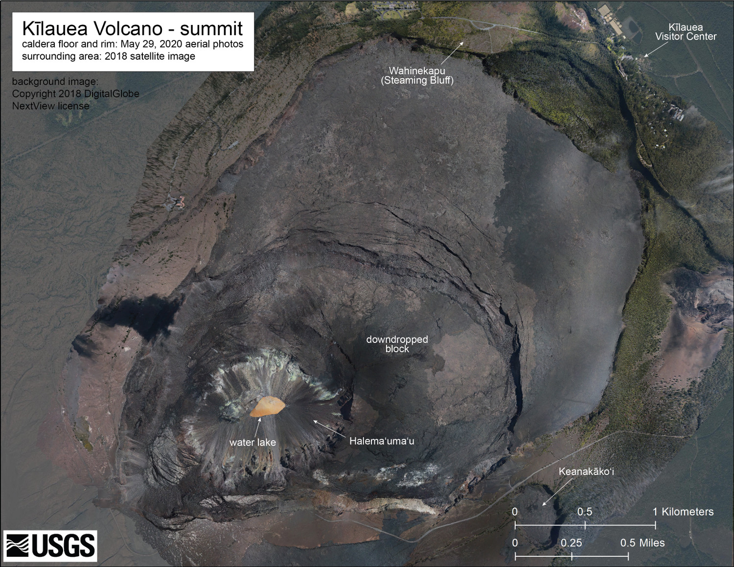
The May 29 overflight provided updated aerial photographs of Kīlauea summit, covering the caldera floor and showing the current size of the water lake in Halema‘uma‘u crater. The label “downdropped block” shows the large portion of the caldera floor that subsided, along with the Halema‘uma‘u region, during the 2018 eruption. The surrounding area is shown by a 2018 satellite image. (USGS)
(BIVN) – Over the last month, the USGS Hawaiian Volcano Observatory has published a variety of new videos, photos – and even a a new map of Kīlauea summit – as the volcano marks its one-year alert status anniversary.
Kīlauea has been at the NORMAL alert level since June 25, 2019.
Among the new imagery is a thermal video of Kīlauea’s summit water lake posted on June 23, and a wide-angle video of the summit captured during a helicopter overflight on May 29. Photos taken during the overflight were used to construct a 3D model of the summit. Video of the 3D model was published on June 1.
Last month, Sherry Bracken spoke to then USGS HVO Scientists-in-Charge Tina Neal about the status of Kīlauea for the Island Conversations radio broadcast on KWXX.
“The volcano is fairly quiet,” Neal said. “That doesn’t mean we aren’t seeing changes and we aren’t seeing signs of activity. It’s just that it’s a very low level and we don’t feel that there’s any imminent threat.”
“The overall picture of Kīlauea right now, is that the magmatic system is
slowly recharging that is recovering from the big events of 2018,” Neal said. “There are signs that magma may be re-accumulating in the shallow reservoir system at a low rate and also re-accumulating in the East Rift Zone, but we’re not seeing signs of ramping up of either earthquake activity or deformation.”
“There are some changes here and there that we’re watching carefully,” Neal continued, “but overall the volcano is pretty quiet.”
Neal said scientist are also watching the summit crater lake at Halemaʻumaʻu, which she said “was a wonderful surprise for all of us. In retrospect, it shouldn’t have been surprising, because we know that the collapse of the summit punched deeply enough into the volcano that it reached down below the adjacent water table.”
As of June 3rd, the lake depth was approximately 36 meters or 118 feet. The water lake has a surface area of approximately 6.2 acres, a recent USGS HVO map caption states, which is more than double the area measured in late December. Scientists say the water lake is still smaller in area than the former Halema‘uma‘u lava lake, which was approximately 11.9 acres just before it drained in May 2018.
“We’re trying to keep track of how the lake is changing both in terms of its
depth and size, its color and its behavior,” Neal said, adding that the water has twice been sampled by a UAV. “We’ll be getting additional samples as soon as we can fly the aircraft again,” she said.
“Something we’re keeping an eye on, a big question that the lake poses for people is what does this mean about future eruptions at the summit of Kīlauea, and could they be explosive?” Neal said. “That is certainly a possibility that we’re considering right now: how rising magma – once it hits the surface beneath the lake would interact and produce explosions – is something that’s very much on the minds of our geologists.”

by Big Island Video News8:21 am
on at
STORY SUMMARY
HAWAIʻI ISLAND - The Hawaiian Volcano Observatory has published a new thermal view of the summit crater lake, a flyover video, a 3D model, and a map.