(USGS HVO June 2019)
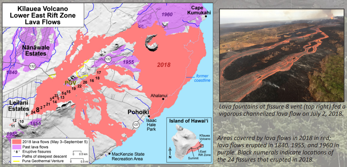
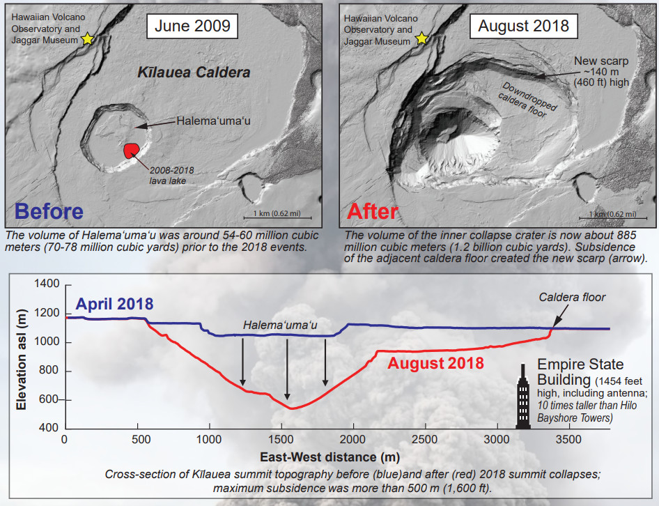
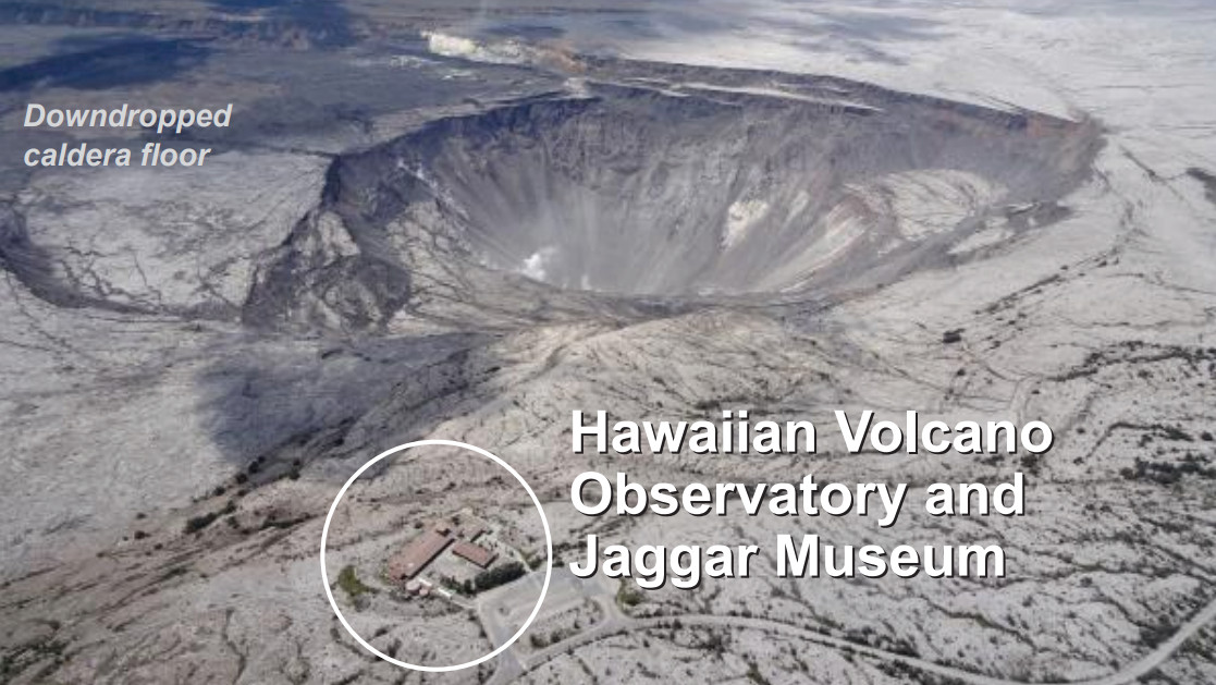
(BIVN) – A scientific, summary chronology and interesting facts has been published about last year’s lower East Rift Zone eruption and summit collapse at Kīlauea Volcano.
On June 10, the USGS Hawaiian Volcano Observatory posted the new overview on its website. The two page document includes photographs, illustrations, and a written timeline of the dramatic and destructive events of last summer.
The Chronology reads:
- April 30 Long-term Puʻu ʻŌʻō eruptive vent collapses; magma begins moving downrift toward Puna
- May 1 HVO issues notice of potential eruption on Kīlauea’s lower East Rift Zone. Deflation of Kīlauea’s summit begins and Halemaʻumaʻu lava lake starts to drop
- May 3 Onset of fissure eruptions on lower East Rift Zone; Volcano Alert Level raised to WARNING
- May 4 Magnitude-6.9 earthquake on south flank of Kīlauea
- May 9 HVO issues notice of potential summit explosions; lull in lower East Rift Zone fissures May 9-12
- May 10 Halemaʻumaʻu lava lake disappears from view
- May 11 Hawaiʻi Volcanoes National Park closes to the public (Kahuku Unit remains open)
- May 15 Aviation Color Code elevated to RED in anticipation of summit explosive events
- May 16 Onset of Kīlauea summit explosive events; HVO building evacuated
- May 19 Lava enters ocean near Mackenzie State Recreation Area (lasts about 10 days)
- May 25 Fissure 8 reactivates; new pit opens on the floor of Halemaʻumaʻu
- May 29 Caldera downdrop accelerates; onset of near-daily summit collapse events, with each releasing energy equivalent to a magnitude-5+ earthquake
- June 3 Lava erupted from fissure 8 reaches ocean at Kapoho Bay
- June 24 Collapse events no longer producing ash; Aviation Color Code lowered to ORANGE
- Aug. 2 Summit collapse events end
- Aug. 4 Fissure 8 activity significantly decreases; summit deflation stops
- Aug. 17 Eruptive pause at fissure 8; Volcano Alert Level lowered to WATCH
- Aug. 21 Ocean entry no longer active
- Sept. 1-5 Sporadic glow/weak lava activity within fissure 8 cone; no active lava observed after Sept. 5
- Sept. 22 Hawaiʻi Volcanoes National Park reopens (details at nps.gov/havo)
- Oct. 5 Kīlauea Volcano Alert Level lowered to ADVISORY; lowered to NORMAL on March 26, 2019

(USGS HVO June 2019)
The document includes these Facts and Statistics:
- Largest lower East Rift Zone eruption and summit collapse in at least 200 years (Overview)
- 13.7 square miles of land inundated by lava (maximum thickness: 180 feet on land, ~ 920 feet in lava delta)
- 875 acres of new land created by ocean entries
- 716 dwellings destroyed by lava (per Hawaiʻi County)
- ~30 miles of roads covered by lava
- ~1 billion cubic yards of lava erupted (enough to cover two lanes of I-90 from Boston, MA, to Seattle, WA–around 3,020 miles–with lava about 70 feet deep, or enough to fill at least 320,000 Olympic-size swimming pools)
- Magnitude-6.9 south flank earthquake on May 4 the largest in Hawaii since 1975
- 62 summit collapse events, May 16 to August 2 (each released energy equivalent to a M5.2–M5.4 earthquake)
- 12 ash-producing explosions May 16–26 (highest ash plume reached ~30,000 feet above sea level on May 17)


by Big Island Video News5:33 pm
on at
STORY SUMMARY
HAWAIʻI ISLAND - The USGS Hawaiian Volcano Observatory has published an updated overview of Kīlauea Volcano's 2018 lower East Rift Zone eruption and summit collapse.