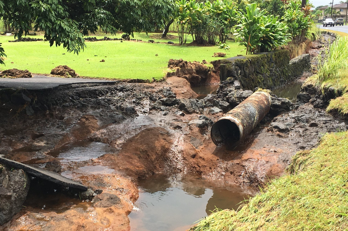
(PHOTO: Hawaii DOT) Culvert damage on Highway 11 past mile marker 10 near Kurtistown.
UPDATE: The Flash Flood Warning has been extended for the island of Hawai‘i until 11 p.m. HST. Forecasters said:
At 727 PM HST, radar and rain gauges showed persistent heavy rain over the lower Puna District. The most intense rainfall of 2 to 4 inches per hour was around Pahoa and Hawaiian Beaches, extending along Highway 130 toward Hawaiian Paradise Park. Hawaii County Civil Defense reports that flash flooding is occurring in this area. Additional rainfall is expected to move over the east-facing slopes of the Big Island through this evening.
(BIVN) – A Flash Flood Warning remains in effect for East Hawai‘i until 8 p.m. HST. According to the National Weather Service:
At 4:42 PM HST, radar showed intense rain from a thunderstorm over the lower Puna District. The most intense rainfall of 2 to 3 inches per hour was over the area from Hawaiian Paradise Park to Leilani Estates. Additional rainfall is expected to move over the east-facing slopes of the Big Island through early this evening.
“Rain will continue through the weekend so please be careful when travelling on the roads,” Hawai‘i County Civil Defense said in a message. “Closures may occur without any notice.”
Officials also reported:
- The United States Postal Service reports that all post offices except Pepeekeo Post Office will deliver mail tomorrow. However, there are no retail services or mail pickup from blue USPS mail boxes.
- State Highways reports that Highway 19 at mile marker 28-29 (Kaawalii Gulch) remains closed. This closure is to allow crews to remove a dangerous boulder from the hillside. It is unknown at this time how long the highway will be closed.
- State Highways has installed a temporary traffic light on Highway 11 near mile marker 30 (Volcano Golf Course) due to a one lane closure. This closure will allow crews to make repairs to earthquake and flood damaged sections of the highway. Repairs are expected to last about two weeks.

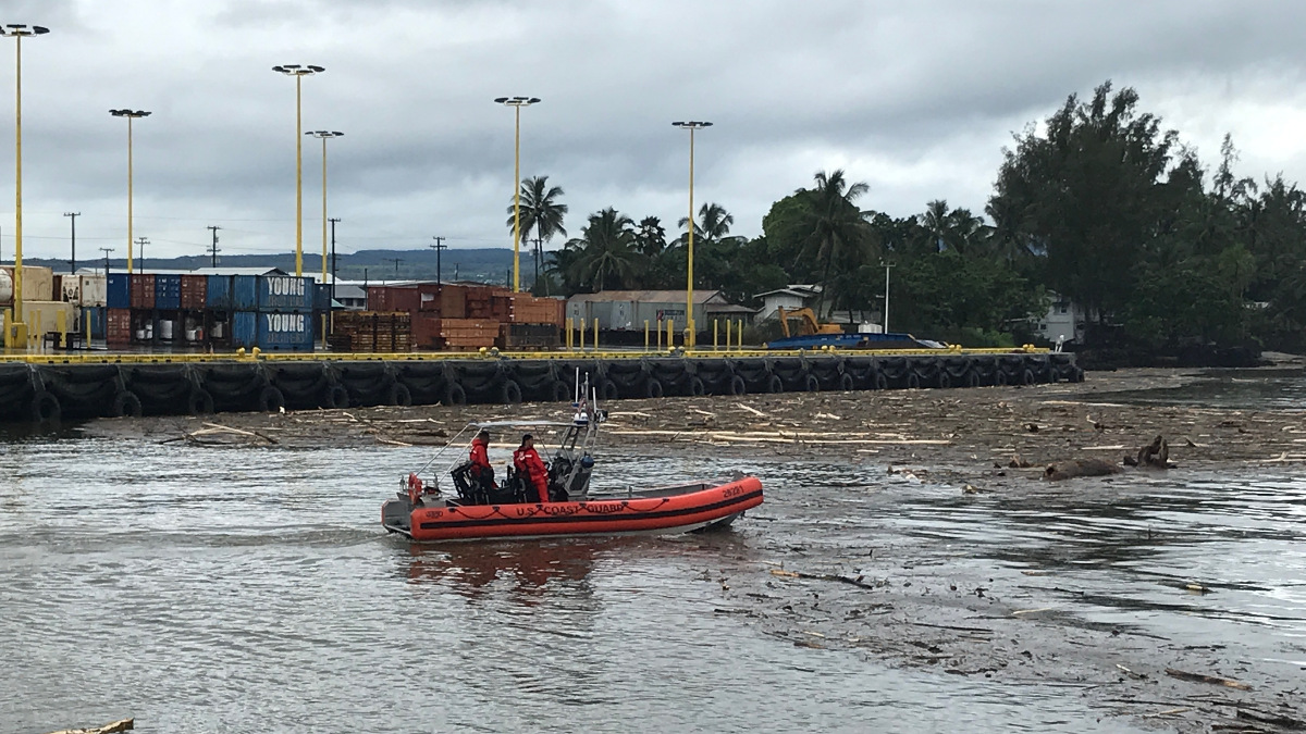
(USCG PHOTO) A Coast Guard small boat crew making an assessment of the port of Hilo on Aug. 24, 2018.
The first commercial shipping traffic returned to Hilo Harbor today, after the U.S. Coast Guard Captain of the Port reopened the harbor to commercial traffic. Hilo harbor was closed to all commercial traffic during the impacts of Hurricane Lane and was reopened after the storm had passed and the harbor was deemed safe for vessel traffic.
The Hawai‘i Department of Transportation issued an update on Big Island highways. HDOT Highways Division Hawai‘i District staff conducted assessments and reported the following:
Highway 11
- MM8 – Stream debris on shoulder and in culvert.
- MM 10 – Culvert blocked and needs clearing.
- MM 11 (Sugar Mill Road/Kaupakuea Homestead Rd) – Water crossing road at culvert. No damage visible on initial inspection.
- MM 15.5 – Pavement cracking observed on shoulder of Hilo bound lanes.
- MM 18 to 20 – Potholes found on inbound and outbound lanes.
- MM 21 – Potholes on Kau side of Hirano Store.
- MM 30 – Restricted to one lane as crews work to clear trees and branches. Cracks and sinking pavement in the area.
- MM 50 – Shoulder undermined on Pahala bound side of the road.
Highway 19
- MM 2.74 (Wailuku Br, Hamakua side) – Road reopened.
- MM 3.8 – Landslide blocking Hilo bound lane.
- MM 3.47, MM 6, MM 19, MM 21.76 – Road reopened.
- MM 11 – Approximately 300’ stretch of road with large potholes.
- MM 11.4 – Potholes observed.
- Before MM 13 – Multiple landslides blocking shoulders of northbound lane; lane remains open.
- MM 13 – Landslide in northbound lane and shoulder; northbound lane remains open. Landslide blocking southbound shoulder.
- MM 13.5 (near Honomu Road) – Landslide blocking southbound shoulder.
- MM 14 (near Kolekole Bridge) – Landslide blocking southbound shoulder.
- MM 14.1 – Potholes observed.
- MM 15.54 (Hakalau Bridge) – Mud on bridge deck. Road remains closed.
- MM 28.5 (Kaawalii Gulch) – Rock scaling operations took place late Saturday afternoon. Additional scaling and debris removal continues late Saturday with intermittent traffic control.
Bayfront Highway remains closed due to flooding.
Highway 130 at MM 2.8 – Tree and debris behind guardrail of Pahoa bound lanes.
Akoni Pule (Highway 270) at MM 25 – Debris after several landslides cleared and one lane reopened.
Daniel K. Inouye Highway (Saddle Road) between MM 8.9 to 11.1 – 2.3 miles of shoulder damaged or eroded and an estimated 15,000-20,000 cubic yards of material displaced by flood waters. Road reopened.
Kohala Mountain Road (Highway 250)
- MM 13 – Road reopened.
- MM 13.1 – Trees/branches down blocking shoulder.

by Big Island Video News6:30 pm
on at
STORY SUMMARY
HAWAII ISLAND - Hilo port is open, and the Hawaii DOT has posted a detailed post-Hurricane Lane damage assessment of state roads on the Big Island.