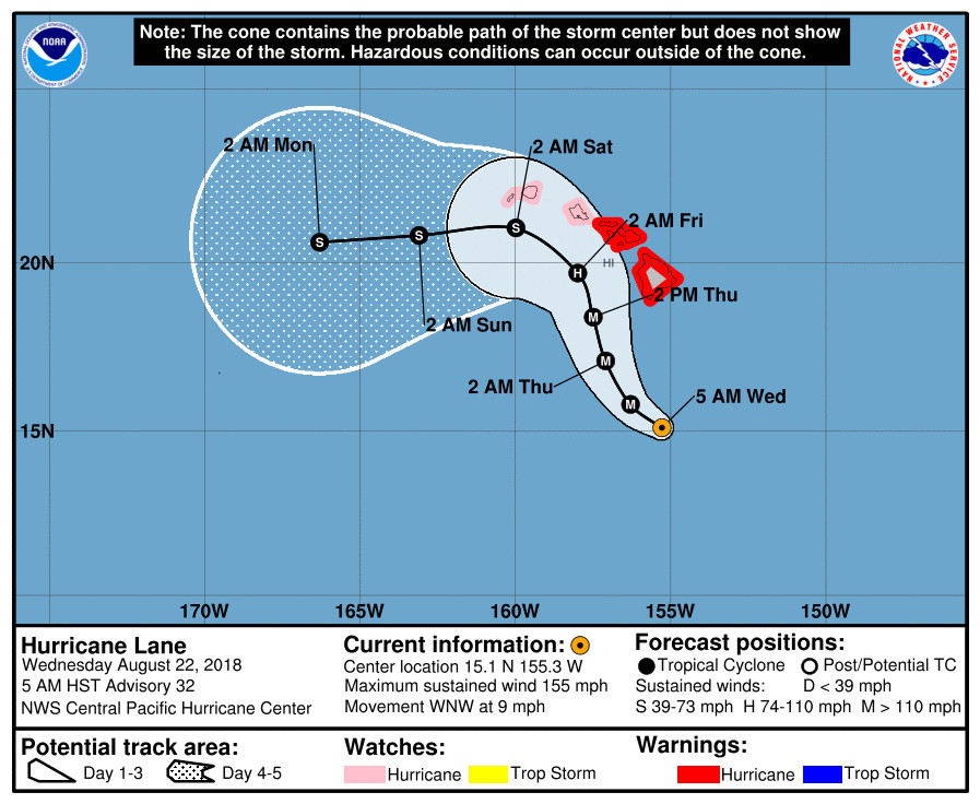
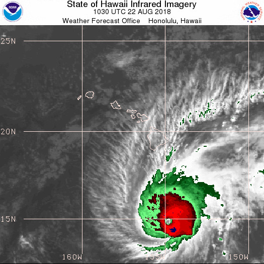
(BIVN) – A Hurricane Warning remains in effect for Hawaii Island as powerful Hurricane Lane continues to move west northwest towards the state.
The storm weakened a bit overnight. Maximum sustained winds are now 155 mph, bringing Lane back down to a strong category 4 hurricane on the Saffir-Simpson Hurricane Wind Scale. Some weakening is forecast during the next 48 hours, the National Weather Service’s Central Pacific Hurricane Center says, but Lane is forecast to remain a dangerous hurricane as it draws closer to the Hawaiian Islands.

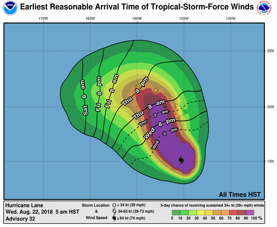
“Tropical storm conditions are expected within the Hurricane Warning area beginning late tonight into early Thursday morning,” forecasters say, “with hurricane conditions expected somewhere within the warning area on Thursday. Tropical storm conditions are possible within the Hurricane Watch area beginning Thursday into Thursday night, with hurricane conditions possible late Thursday night into Friday.”

“Excessive rainfall associated with Lane is expected to affect portions of the Hawaiian Islands from late today into the weekend, leading to flash flooding and landslides,” the National Weather Service says. “Lane is expected to produce total rain accumulations of 10 to 15 inches with isolated amounts greater than 20 inches over the Hawaiian Islands.”
“Large swells generated by Lane will impact the Hawaiian Islands, beginning this morning on the Big Island, spreading across the remainder of the island chain on today,” forecaster say. “These swells will produce large and potentially damaging surf along exposed west, south and east facing shorelines.”
From the 5:36 a.m. National Weather Service forecast discussion:
Lane has started to turn more towards the northwest as forecast by the Central Pacific Hurricane Center (CPHC). The forecast track for Lane continues on a northwest path today before turning more north-northwest on Thursday. Lane’s forecast track will increase the threat for hurricane force winds over the Big Island and Maui County over the next 24 to 36 hours. The Hurricane Warning was expanded this morning to include both Hawaii and Maui Counties.
The onset of damaging tropical-storm-force winds on the Big Island could start later this evening, with dangerous hurricane force winds starting in the overnight hours. In Maui County, damaging winds could begin as early as Thursday afternoon, with dangerous hurricane force winds possible starting on Thursday night. On Oahu, damaging winds could begin as early as Thursday evening, with dangerous hurricane force winds possible by Friday morning. Hurricane Warnings may need to be expanded to include other islands as Lane draws closer. The highest wind threats for the Big Island will develop along the western slopes of the island as strong and gusty down slope winds interact with mountainous terrain. The location of these damaging wind impacts will depend heavily upon the final track of Hurricane Lane.
Deep tropical moisture surrounding Lane will also drift northward ahead of the hurricane through the weekend. Extreme moisture levels surrounding Lane will create an unstable environment with muggy and humid weather conditions along with frequent showers. Heavier rain shower bands will develop with some thunderstorm activity as the extreme moisture interacts with mountainous terrain on each island. These conditions will likely lead to periods of hazardous flash flooding threatening all islands. Hence, a Flash Flood Watch remains in effect for the entire state of Hawaii through Saturday.
The combination of a deep moist unstable layer and strong low level wind shear along and to the east of the track of Lane will make tornadoes and large waterspouts a distinct possibility in the rainbands across the right semicircle of the hurricane. These continue to be included in the TCV and HLS products as an elevated threat from Oahu to the Big Island. Will be able to better refine the threat as Lane approaches.
It’s not possible to know which islands will see the worst storm effects right now due to the close proximity of the hurricane track to the Hawaiian Islands and uncertainties in Lane’s track caused by increasing wind shear through the atmosphere as it moves northward. The CPHC forecasts continue to show that all islands are at risk from direct effects from the core of Hurricane Lane. Everyone should take this hurricane very seriously and should prepare accordingly. It’s also important to expect future adjustments to the track and intensity forecast, particularly with the challenging recurvature forecast that Lane is presenting. Prepare for the worst and hope for the best.
Sunday through Tuesday, there remains a considerable amount of uncertainty in the model guidance as to when the deep moisture in the wake of Lane departs the region. The American GFS model continues to show a deep moisture plume lingering over the entire state through the weekend and into the first half of next week. While the European (ECMWF) model shows a large area of drier air moving in with the easterly trade wind flow. We will need to wait to see how fast Lane transits the Hawaiian Islands and watch for the models trending towards a more consistent solution over this time period.

Due to the Hurricane Warning status, Hawaii County Civil Defense said the following closures are in effect:
- All schools and the University of Hawaii campuses will be closed until further notice.
- All beach parks, from South Point north to Kohala, will be closed until further notice. All pavilion and camping permits for these parks have been cancelled.
- South Point Road from the Kamaoa Road junction to South Point is closed to all traffic.
All other roads are open at this time.
“The Division of Boating and Ocean Recreation (DOBOR) advises all boat owners in unprotected harbors from Milolii to Mahukona to take all measures to secure their vessels. This includes removal, if possible. Complete all actions before nightfall,” civil defense says. “The Department of Education, in coordination with the American Red Cross and Hawaii County Parks and Recreation, have identified shelters in all districts that will be opened if necessary. You will be notified if any of the shelters are opened.”
Hawaii County has also issued a Hurricane Lane emergency proclamation, which states:
WHEREAS, Chapter 127A Hawaii Revised Statutes, provides for the establishment of County organizations for emergency management and disaster relief with the Mayor having direct responsibility and authority over emergency management within the County.
WHEREAS, Chapter 127A Hawaii Revised Statutes and Chapter 7, Articles 1 and 2 of the Hawai‘i County Code, establishes a Civil Defense Agency within the County of Hawai‘i and prescribes its powers, duties, and responsibilities, and Section 13- 23 of the Hawai‘i County Charter empowers the Mayor of the County to declare emergencies; and
WHEREAS, the National Weather Service at 5:00 p.m. HST on August 17, 2018 issued Hurricane Lane Advisory Number 17 advising that Hurricane Lane had entered Hawaiian waters and was located at 12.8 North Latitude/141.0 West Longitude or 930 miles south east of Hilo, Hawai‘i as a Category 4 hurricane with maximum sustained winds of 145 mph and;
WHEREAS, the National Weather Service at 5:00 a.m. HST on August 21, 2018 issued Hurricane Lane Advisory Number 27 advising of a Hurricane Watch for the County of Hawai‘i. Hurricane Lane was located at 14.1 North Latitude/152.3 West Longitude or 450 miles south east of Kailua-Kona, Hawai‘i as a Category 4. hurricane with maximum sustained winds of 150 mph and;
WHEREAS, a Hurricane Watch means that possible tropical storm conditions can occur any time within the next 48 hours; and
WHEREAS, conditions associated with hurricanes and tropical storms include but are not limited to storm surge, high surf, high winds, flash flooding and heavy rain may occur; and;
WHEREAS, due to the possibility of imminent disaster due to property damage and/or bodily injury to residents of Hawai`i Island, and the need for government agencies and representatives from the private sector to mobilize and provide immediate services to our island residents, a state of emergency is authorized pursuant to Chapter 127A Hawaii Revised Statutes, and Chapter 7, Hawai`i County Code.
NOW, THEREFORE, I, HARRY KIM, Mayor of the County of Hawai‘i, do hereby proclaim and declare that a state of emergency exists due threat of imminent disaster on the Hawai‘i Island, effective 7:38 a.m., August 21, 2018, and continuing thereon for 60 days or until further act by this office.
IN WITNESS WHEREOF, I have hereunto set my hand and caused the Seal of the County of Hawai‘i to be affixed. Done this 21st day of August 2018 in Hilo, Hawai‘i.
HARRY KIM
Mayor
County of Hawai‘i

by Big Island Video News6:59 am
on at
STORY SUMMARY
HAWAII ISLAND - If Hurricane Lane's present movement continues, "residents of West Hawaii must take necessary precautions," civil defense officials say.