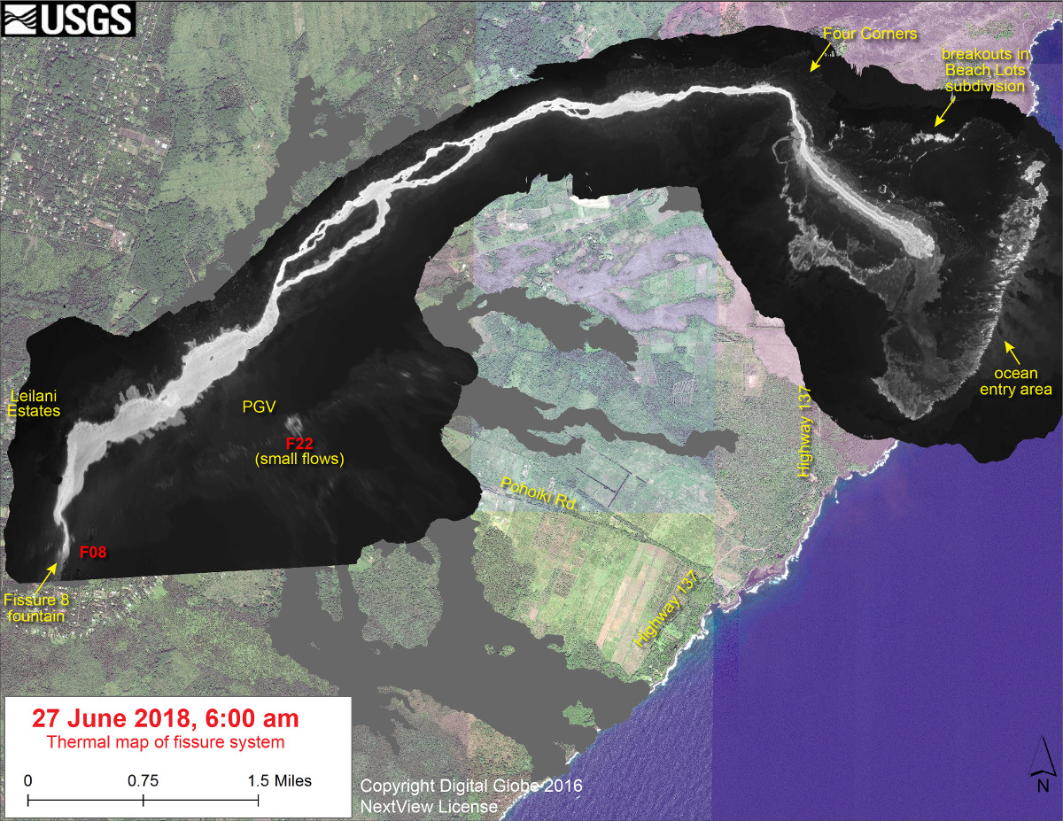
USGS: This thermal map shows the fissure system and lava flows as of 6 am on Wednesday, June 27. The fountain at Fissure 8 remains active, with the lava flow entering the ocean at Kapoho. Small breakouts were observed this morning in the area of Kapoho Beach Lots. Very small, short flows were observed today near Fissure 22. The black and white area is the extent of the thermal map. Temperature in the thermal image is displayed as gray-scale values, with the brightest pixels indicating the hottest areas. The thermal map was constructed by stitching many overlapping oblique thermal images collected by a handheld thermal camera during a helicopter overflight of the flow field. The base is a copyrighted color satellite image (used with permission) provided by Digital Globe
(BIVN) – The eruption in the lower East Rift Zone (LERZ) continues with no significant change during the past 24 hours, while another collapse explosion happened this morning at the summit of Kīlauea Volcano.
The summit collapse explosion occurred at 4:49 a.m. HST. An ash-poor plume rose about 1,000 ft. above the ground and drifted southwest, the USGS Hawaiian Volcano Observatory reported. The energy released by the event was equivalent to a Magnitude 5.3 earthquake.
On the East Rift Zone, Fissure 8 continues to be very active and is feeding a lava channel to the ocean at Kapoho. “The flow is expanding south along the shoreline, and is also oozing fresh lava at Kapoho Beach Lots,” Hawaii County Civil Defense stated this morning. “Gas emissions from the fissure eruption and laze at the ocean entry continue to be very high.”
“Due to active lava near houses in Kapoho, access by residents is not allowed,” officials said.
Disaster assistance is available island-wide to individuals and businesses in Hawaii County that have been affected by the Kilauea eruption.
- The Disaster Recovery Center is open daily from 8am to 8pm, and is located at the Keaau High School Gym. If you need a ride, buses run between the two shelters and the Disaster Recovery Center.
- The Disaster Recovery Center is staffed with representatives from FEMA, the U.S. Small Business Administration, and State and County agencies.
- For more resources to help you recover from this disaster, please visit the Civil Defense website.

by Big Island Video News
on at
STORY SUMMARY
HAWAII ISLAND - The flow is expanding south along the shoreline, and is also oozing fresh lava at Kapoho Beach Lots, officials reported this morning.