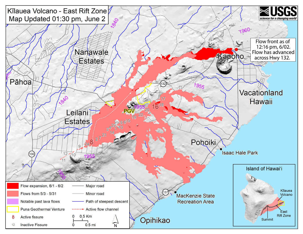
USGS: Map as of 1:30 p.m. HST, June 2, 2018. Given the dynamic nature of Kīlauea’s lower East Rift Zone eruption, with changing vent locations, fissures starting and stopping, and varying rates of lava effusion, map details shown here are accurate as of the date/time noted. Shaded purple areas indicate lava flows erupted in 1840, 1955, 1960, and 2014-2015.
UPDATE (7:45 a.m.) – As of a 7:30 a.m. HST overflight, the USGS Hawaiian Volcano Observatory says lava was about 430 yards from the ocean between Kapoho Beach Road and Kapoho Kai Drive.
UPDATE (6:30 a.m.) – Lava has reached Kapoho Kai Road to the south, Hawaii County Civil Defense reported in this morning’s update. “Please contact Civil Defense if you confirm that someone you know is remaining in the isolated area. Call (808) 935-0031.”
Lava Inundates Kapoho
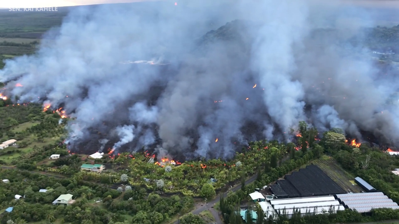
A wide lava flow originating from Fissure 8 in Leilani Estates crossed Highway 137 near the Four Corners intersection at 9:30 a.m. Saturday morning and, hours later, advanced into Kapoho Beach Lots. Video recorded by Senator Kai Kahele – on HIANG drill weekend performing duty in lower Puna with Task Force Hawai’i, JTF50 in support of the evacuations in Kapoho/Vacationland – shows the lava making its way towards the ocean, destroying everything in its path. Kahele said civilians still in Kapoho were directed to go to Pohoiki / Issac Hale Beach Park for potential extraction and U.S. Army Blackhawks landed at designated landing zones ready to assist with the evacuation.
At 2:40 a.m., the USGS Hawaiian Volcano Observatory reported a University of Hawaii-Hilo UAS thermal imaging flight “indicates that lava is about 500 yards from Kapoho tidepools. Flow front is about 0.5 miles wide and extends from Kapoho Beach Road almost to Kapoho Kai Drive and down to Ililani Road.”
There is no access to Kapoho, Vacationland, Highway 132, and Highway 137, Hawaii County Civil Defense says. “Government Beach Road, between Kahakai Boulevard and Cinder Road, is open to Waa Waa and Papaya Farms Road residents only with official credentials,” officials say. “There is no curfew.”
Video by Sen. Kai Kahele, audio by Hawaii County Civil Defense.
Green Lake Evaporated
At 10 a.m. on Saturday, as the Fissure 8 flow was crossing Highway 137, lava entered Kai Wai a Pele, or Green Lake, within Kapoho Crater. The interaction produced a large steam plume that was seen for miles. “By 1:30 p.m. the steam plume had ceased and by 3 p.m., a Hawaii County Fire Department overflight reported that lava had filled the lake and apparently evaporated all the water,” USGS said.
Leilani Estates Evacuation Zone A Ghost Town
The mandatory evacuation area east of Pomaikai Street in Leilani Estates is mostly deserted. Barricades block streets and the landscape is covered by crunchy tephra, ejected by fissure eruptions. Dangerous volcanic gas is everywhere. On Moku Street and Leilani Avenue, the atmosphere is dominated by the fountaining of Fissure 8. The nearby Leilani Estates Community Center sits empty. The facility is in the restricted zone. Just outside the subdivision, the lava flows that crossed Pohoiki Road and Highway 132 just east of “the Y” have inflated into mountainous roadblocks.
Video by Dave Corrigan, recorded on June 2, 2018.
The Summit
“Earthquake activity at the summit overnight was low,” USGS reported on June 2 at 7:39 p.m. “Ash emissions are low as revealed by webcam views this morning. Small explosive events could produce minor amounts of ash fall downwind at any time. Volcanic gas emissions at the summit remain high.”
Puna Insurance Claims Forum
The State and County of Hawai’i and Hawaii Public Adjusters will host a forum on Thursday, June 7, from 3:30 to 6:30 p.m. at the Hawaiian Shores Community Association Building, commonly known as ”The Stables”, located in Hawaiian Beaches. “United Policy Holders, Hawaii County Bar Associates and Professionals from Hawaii Public Adjusters will be on hand to present the general means, methods and standard practices for filing claims,” an event flyer stated. “Q&A period to follow to allow policyholders and others to clarify concerns about filing disaster claims and find out more information about where to obtain professional help.”
Seven People Cited Friday Night
Seven people were cited Friday night for loitering in a volcano disaster zone, according to a State Department of Land and Natural Resources news release:
People trying to get close-up views of lava in Lower Puna were cited by DLNR Division of Conservation and Resources Enforcement (DOCARE) officers last night. Seven individuals will have to make court appearances to face charges of loitering in a disaster zone under Hawai‘i County code. Since the beginning of the East Rift Zone eruption in early May, DOCARE has been assisting Hawai‘i County Police, the Hawai‘i County Civil Defense Agency and the National Guard in manning check-points and conducting patrols to keep people out of dangerous areas.
Joseph Tomaselli, age and hometown unknown because he didn’t have identification and 64-year-old Steven Vige of Castaic, CA were in a car together on a back road leading into Lava Tree State Park. Officers report confiscating an entrance placard from Tomaselli since it was not being used for its intended purpose to get personal items out during an evacuation.
In the same area, two Lāhainā, Maui men were also cited for loitering in a disaster area. They are 35-year-old Dilbert Shaw and 34-year-old Larrick Euband. Also cited were 20-year-old Matt Magura of Germany and 23-year-old Michael Eisgruber of New York State.
The seventh person, Joseph Anthony of Hong Kong was cited in the Kapoho Beach Lots area and his camera was confiscated as evidence.
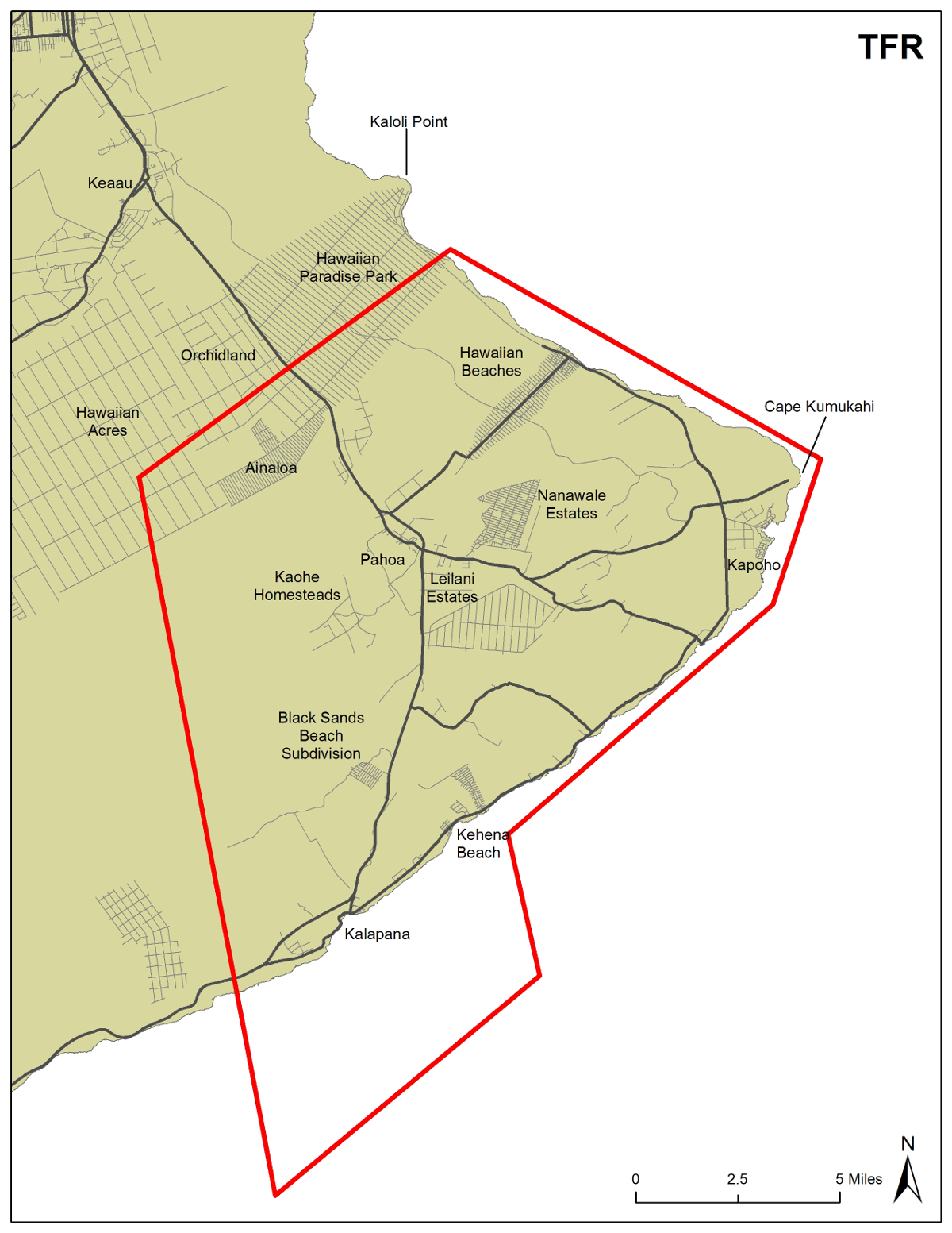
Earlier this week a California couple was cited for entering a closed area, as was a California man who was operating a drone in the Temporary Flight Restriction (TFR) area. The TFR was expanded by the Federal Aviation Administration on Friday and now includes additional coastline, ocean waters; and lands to the north and east of Pahoa. Civilian drone operations are not permitted in the TFR and pose a risk to emergency, rescue, and hazard assessment air operations.

Temporary Flight Restriction Map Courtesy Hawai’i Civil Defense Agency


by Big Island Video News6:41 am
on at
STORY SUMMARY
HAWAII ISLAND - The daily morning update summarizing the last 24 hours in the ongoing volcanic eruption of Kilauea Volcano.