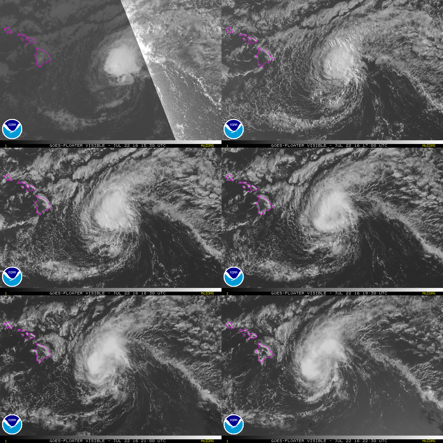
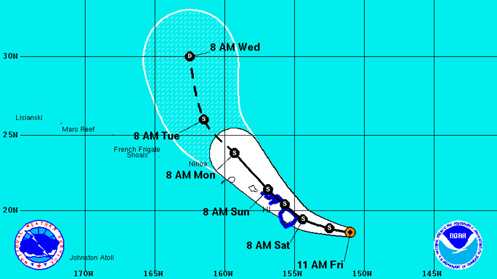
HAWAII ISLAND – A Tropical Storm Warning remains in effect for Hawaii County and has also been issued for Maui County, as Tropical Storm Darby is now 280 miles east of Hilo and heading west towards the Big Island.
Hawaii Mayor Billy Kenoi today signed an emergency proclamation in anticipation of Darby’s arrival. The proclamation allows easier access to county emergency resources, along with the suspension of certain laws as needed for emergency purposes.
“We want to make sure we are doing everything possible to protect the public,” said Mayor Kenoi. “This proclamation improves the county’s ability to respond quickly to any potential impacts from the impending storm.”
The disaster emergency relief period for the proclamation began today at noon and will continue for 60 days.
Hawaii County officials advise the public to be storm ready, as damaging rains are expected to begin affecting the Big Island later today. Residents are urged to complete storm preparations before nightfall.
“Your preparations should be rushed to completion,” the National Weather Service advised. “In a tropical storm, conditions can change quickly. Evacuate if directed to do so by local officials, or if your home is vulnerable to high winds or flooding.”
Darby has not gotten any weaker since this morning, with maximum sustained winds are near 60 mph (95 km/h) with higher gusts. Some weakening is forecast during the next 48 hours.
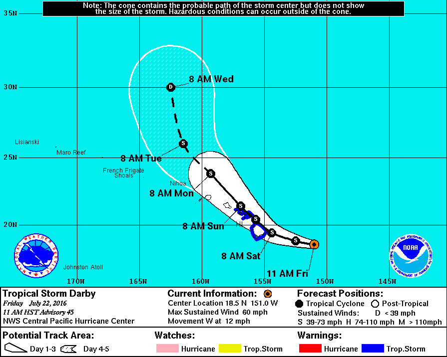
The center of Darby will be approaching the Big Island Saturday morning and “will pass very near, or over, the Big Island on Saturday,” the National Weather Service reports. “A gradual turn toward the northwest is expected later Saturday, with the center of Darby expected to pass very near, or over, Maui county Saturday night. However, rain and wind will increase well ahead of the center.”
Tropical-storm-force winds currently extend outward up to 125 miles from the center.
“Should power be lost or access be blocked – ensure you have prescription medications, ice, water, oxygen, backup power and fuel if needed,” stated Hawaii County Civil Defense.
HAWAII COUNTY CLOSURES
All camping and pavilion reservations at County and State parks have been cancelled today through Sunday.
All backcountry areas and certain roads in Hawai‘i Volcanoes National Park, are closed effective 5 p.m. today.
County lava viewing and swimming pools are closed effective noon today.
Beginning Saturday, all State and County park facilities are closed until further notice.
EMERGENCY SHELTERS
“If possible and safe, shelter in place or with family and friends,” civil defense says. “However, the following pet friendly emergency shelters open today at 4 pm: Waiakea High, Kalanianaole Elementary, Keaau High, Pahoa High, Honokaa High and Intermediate, Kealakehe High, Konawaena High and Ka’u High. Requirements for pets that need shelter are listed at hawaiicounty.gov. Bring bedding, food, water and any personal items you may need.”
Hilo High, Laupahoehoe Community Charter School, Mountain View Elementary, Waikoloa Elementary, and Kohala High and Elementary open today at 4 pm but are unable to accommodate pets. Again, bring bedding, food, water and any personal items you may need.
HAZARDS: HIGH WINDS
Tropical storm force winds over 39 mph are expected to begin overspreading the Big Island late tonight. “In some areas, winds will be as high as 50 to 60 mph with gusts to 70 mph,” forecasters say. “Even higher gusts will be possible over mountainous terrain, through passes, and where winds blow downslope. These effects can occur well away from the center of Darby.”
“Homes may have damage to roofs, siding, gutters and windows, especially if these items are not properly secured. Loose outdoor items will become airborne, causing additional damage and possible injury.
“Many power lines will be knocked down by falling trees, resulting in extended power outages in some areas. Many large branches of trees will be snapped, and many weaker trees will be snapped or uprooted.”
“Keeping our employees and our community safe is our top priority as we prepare for and respond to storms,” said Rhea Lee-Moku, public information officer for the Hawaii Electric Light Company. “We strongly encourage everyone to complete their emergency preparations and monitor local news to stay informed. If the Hawai‘i Island electric grid is impacted by Darby, our employees will be deployed to the field to conduct damage assessments and start the process of restoring power once it is safe to do so. We will not send our employees out in dangerous conditions.”
Since Tropical Storm Iselle in August 2014, HELCO says it has spent an estimated $14 million to clear trees and other vegetation such as eucalyptus and palms that may topple and damage power lines. “Since 2014, nearly 94,000 trees were cleared, 31,000 of which were albizia,” HELCO says. “The company regularly inspects trees and contracts certified vegetation management crews to trim trees growing into power lines along roadways and throughout the island.”
HAZARDS: HIGH SURF
A high surf warning is in effect for east facing shores of the Big Island and Maui. “Surf is expected to build to 15 to 25 feet today with occasional higher sets,” forecasters say. “This may cause significant wave runup and damage on some windward coastal roads. Refer to the high surf warning for more details.” Morning observations indicated wave heights were already at 20 feet, forecaster reported.
HAZARDS: HEAVY RAIN
A flash flood watch is in effect. “Showers will increase on the Big Island tonight, followed by heavy rain and squalls with embedded thunderstorms Saturday into Sunday,” weather forecasters say. “These conditions will spread to Maui county on Saturday as well. Refer to the flash flood watch for more details on the flood threat from Darby.”
Total rainfall in the amount of 10 to 15 inches is expected, with locally higher amounts. The rain could cause life-threatening flash floods as well as landslides.
DARBY DISCUSSION
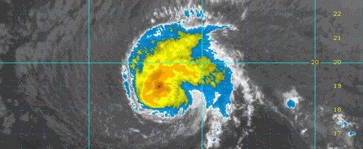
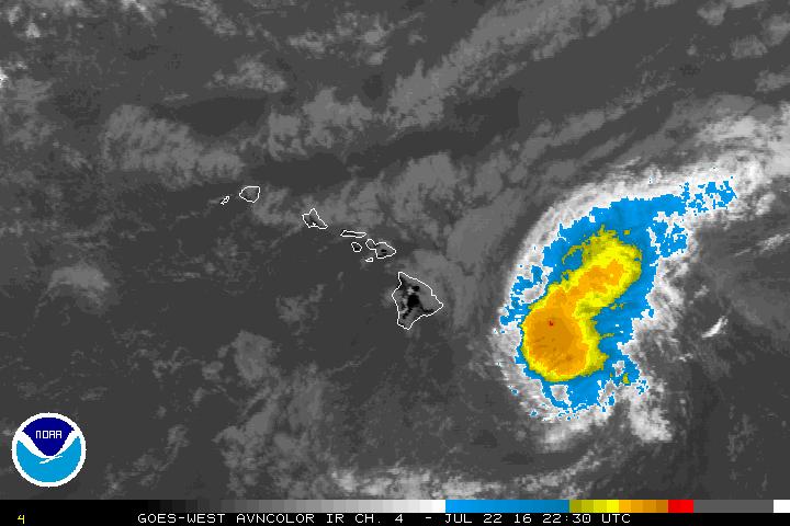
Deep convection associated with Darby was mainly in the system’s northern semicircle with persistent tops colder than -70C. An SSMIS pass from 1732 UTC indicated the system was tilted toward the east. The first Air Force Reserve 53rd Weather Reconnaissance Squadron mission into Darby found maximum SFMR winds of just over 50 knots but the initial passes had difficulty determining the location of the low level center. Based on the recon data thus far, the tropical storm force radius was expanded slightly in the northern semicircle and Darby has been held at 50 kt for this advisory package.
Darby is estimated to be moving at 270/10 kt to the south of a ridge. This ridge is forecast to weaken due to a low pressure system digging southward to the north of Darby. This is expected to decrease the forward motion over the next day, and increase the amount of vertical shear on the tropical cyclone this weekend. The trusted objective aids are consistent with this scenario but have shifted southward slightly with some solutions indicating landfall over the Big Island. As a result, the current forecast has been shifted southward a bit and is between the dynamical consensus and the previous forecast. Given current guidance trends, a direct impact on the Big Island and Maui is a distinct possibility this weekend.
The main factors affecting the intensity forecast include marginal sea surface temperatures, the amount and timing of vertical wind shear, and the effects of any potential interactions with the Hawaiian Islands. Sea surface temperatures will remain marginal near 26.5C over the next couple of days but vertical shear is expected to increase as the previously mentioned upper level trough digs farther south. This shear increase is not expected to be significant until later this weekend. Thus, the forecast is close to the previous package which has Darby only slowly weakening and maintains the cyclone as a tropical storm through the weekend. This is close to the intensity consensus guidance. Note that interactions with the main Hawaiian Islands may cause significant disruptions to Darby and so the intensity forecast confidence is not high at this time.
Interests outside of the warning areas in the Hawaiian islandsshould monitor the progress of Darby, as it could eventually have impacts on all islands through early next week. Remember, it is important not to focus too closely on the exact track and intensity forecasts because the average track error 72 hours out is near 100 miles, while the average intensity error is about 15 kt. In addition, the hazards of a tropical cyclone can extend over a broad area well away from the center.NWS CENTRAL PACIFIC HURRICANE CENTER HONOLULU at 11 am HST

by Big Island Video News1:07 pm
on at
STORY SUMMARY
HAWAII ISLAND (BIVN) - Given current guidance trends, forecasters say a direct impact on the Big Island and Maui is a distinct possibility this weekend. Emergency officials have prepared shelters and initiated various closures as Darby nears.