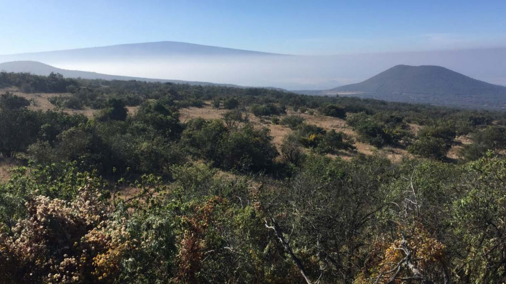
photo courtesy Palila Forest Discovery Trail draft EA
MAUNA KEA, Hawaii – A nearly mile-long, self-led loop trail planned for the high-elevation forest on the western slope of Mauna Kea will take hikers on an informative jaunt through the Palila Critical Habitat.
The Mauna Kea Forest Restoration Project, in collaboration with private and public partners, has posted a draft environmental assessment for the Palila Forest Discovery Trail. The project could get underway in summer of 2016 and is estimated to cost approximately $170,255. The initiative includes trail building and access improvements, informational signage and kiosks, website and literature development, volunteer management, and forest restoration.
The draft EA, prepared by the Department of Land and Natural Resources, anticipates a Finding of No Significant Impact.

Disturbance of vegetation will be restricted to just the extent necessary to accommodate a trail, which can be moved and adjusted to avoid removing most individuals of native species. Ground disturbance associated with the project will be very minimal and limited to hand tool labor, stepbuilding, rock-stacking and kiosk and sign emplacement. Because of these limitations, no grading or NPDES permits will be required, although erosion, sedimentation and dust will be controlled. The trail is located within the Conservation District and Palila Critical Habitat, and the project will protect the values of these areas. No threatened or endangered (T&E) plant species are present at or near the disturbance footprint, and the purpose of the project is to enhance education about and protection for native species, including the endangered palila. Timing of project activities will avoid or minimize impacts to T&E birds. No historic or cultural properties will be affected. Adverse visual impact will be extremely minor and compensated for by the addition of viewpoints for hikers of the forest and wider landscape. Depending on future funding availability, DOFAW intends to install composting toilets and a covered picnic shelter. To reduce any fire risk, the parking area will be mowed frequently to avoid any hot car exhaust systems from igniting tall gas, and fire prevention signage will also be installed at the trailhead. In addition to its ongoing quarterly incipient invasive species checks, MKFRP will maintain a sign at the checking station advising users to clean boots and gear prior to hiking to minimize introduction of invasive species.”DLNR in draft EA

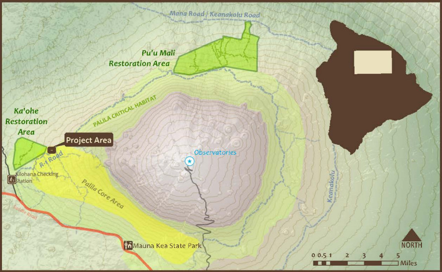
map courtesy Palila Forest Discovery Trail draft EA

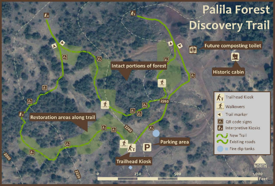
map courtesy Palila Forest Discovery Trail draft EA
Details from the draft EA:
1.1 Project Location and Description
The Mauna Kea Forest Restoration Project (MKFRP) of the Department of Land and Natural Resources, Division of Forestry and Wildlife (DLNR-DOFAW), is collaborating with the American Bird Conservancy, the Mauna Kea Beach Hotel, and several community volunteer groups to construct and maintain the Palila Forest Discovery Trail. This multi-faceted initiative includes trail building and access improvements, informational signage and kiosks, website and literature development, volunteer management, and forest restoration. The 0.92-mile loop trail will meander through a representative and mostly intact portion of the high-elevation forest dominated by native māmane and naio trees on the slopes of Pu‘u Lā‘au, Mauna Kea (Figures 1-4).
To construct the trail, between 5 and 20 volunteers would work over the course of about seven days spread out over approximately a month. Work will involve mainly hand tools such as picks, pruners and pulaskis, with limited use of weedeaters and chainsaws. To avoid erosion, steps and waterbars will be installed using plastic lumber in strategic locations along the trail. No heavy equipment would be used, and no grading would take place. Construction would commence in the summer of 2016. The project would cost approximately $170,255, which includes about $20,000 in State funding, $31,000 in equivalent volunteer hours, and almost $120,000 in donations from foundations and organizations.
Hikers will be self-led through the loop trail and exposed to several interpretive opportunities. Four kiosks placed strategically along the trail at key points will provide detailed information about the area. In addition, small informational markers will be placed along the trail that will also include a QR code to link hikers with smartphones with additional information such as bird calls and plant IDs. Visitors and residents alike will be able to explore and learn about a part of Hawai‘i few know even exists. In order to minimize forest disturbance, the trail is designed as a “Wildland” trail using the natural dirt tread. To accommodate for ADA users, the main trailhead kiosk sign will summarize all the key points along the trail. In addition, there will be a companion website linked through QR codes that detail points of interest along the trail. Even from the parking area, a user will be able experience the main features of the trail.
Native plant species will be planted in areas where the forest is in need of restoration from over 200 years of grazing and browsing by non-native animals including sheep and goats. Planting will improve habitat for not only the critically endangered palila (Loxioides bailleui) but also other endangered native birds, such as Hawai‘i creeper (Oreomystis mana) and ‘akiapōlā‘au (Hemignathus wilsoni).
The project will place a daily average of about 10 additional users in the Pu‘u Lā‘au area of the Mauna Kea Forest Reserve and Ka‘ohe Game Management Area, which brings with it some impacts. DOFAW will need to slightly increase road maintenance. Currently there is a pit toilet at the Kilohana Hunter Checking Station, where all users must check in before driving to the trail or other Pu‘u Lā‘au locations. Depending on future funding availability, DOFAW intends to install composting toilets near the top of the trail in an area previously used as a gravel quarry. This facility would service all users of the Pu‘u Lā‘au area, including hunters, birders, hikers and researchers, who jointly currently average about 5 to 10 users per day. Depending on future funding availability, a sheltered picnic area may also be constructed at the parking area near the trail head. Although any use of the wildland areas increases wildfire risk, the area is already utilized by diverse users, and adding some hikers on the trail should not unduly increase risk. Fire protection infrastructure in the form of diptanks and fire roads are directly adjacent to the trail. To reduce any fire risk, the parking area will be mowed frequently to prevent hot car exhaust systems from igniting tall grass, and fire prevention signage will also be installed at the trail head. In addition to its ongoing quarterly incipient invasive species checks, MKFRP will maintain a sign at the checking station advising users to clean boots and gear prior to hiking to minimize introduction of invasive species.
1.2 Purpose and Need
The southwest slopes of Mauna Kea above 6,000 feet in elevation are the last refuge of the critically endangered palila (Loxioides bailleui), the lone surviving finch-billed honeycreeper found in the main Hawaiian Islands. Over 95 percent of the population is restricted to the southwest slope. Palila have evolved an extremely specialized diet dependent on māmane trees and associated invertebrates for its survival. Therefore, the only habitats able to sustain palila over the long term are large areas of forest that contain dense stands of large māmane trees and incorporate significant elevational or rainfall gradients to provide year-round food sources. A recreational trail that interprets these fascinating birds and their habitat is an opportunity to provide an enjoyable and healthful recreational experience, which by its very nature advances the awareness and knowledge that assist in protecting this unique resource.

by Big Island Video News10:53 am
on at
STORY SUMMARY
A nearly mile-long, self-led loop trail planned for the high-elevation forest on the western slope of Mauna Kea will take hikers on an informative jaunt through the Palila Critical Habitat.