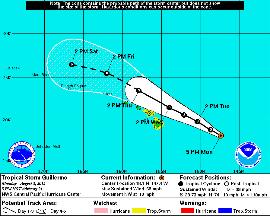
Tropical Storm Guillermo Update – 5 p.m.

- A Tropical Storm Watch is now in effect for Hawaii Island, as well as the Islands of Maui, Molokai, Lanai and Kahoolawe. A Tropical Storm Watch means that tropical storm conditions are possible within the watch area, generally within 48 hours.
- As of 5 p.m. HST Tropical Storm Guillermo was 515 miles east of Hilo, Hawaii. The storm is moving northwest at 10 mph. This motion is expected to continue through Wednesday.The National Weather Service says Guillermo is expected to pass approximately 140 miles northeast of the Big Island on Wednesday. Tropical storm force winds extend outward up to 140 miles from the center.
- Tropical Storm Guillermo’s maximum sustained winds are measured at 65 mph with higher gusts. Steady weakening is expected during the next couple of days.
- A High Surf Advisory is now in effect for east facing shores of all islands. Surf is forecast to be 10 to 14 feet through Tuesday. There is also a Tropical Storm Warning in effect for Hawaiian offshore waters beyond 40 nautical miles out to 240 nautical miles including the portion of the Papahanaumokuakea Marine National Monument east of French Frigate Shoals.
National Weather Service – 5 p.m.
Little has changed through the day with Guillermo looking very ragged in the satellite images. Deep convection has been pulsing northeast of the center… Which has been very difficult to locate without the benefit of aircraft recon. A very timely AMSU pass at 0003 UTC was the main basis for the initial position. Subjective Dvorak intensity estimates from PHFO… SAB and JTWC were all at 55 kt and is the initial intensity for this package.
Guillermo is moving through a break in the ridge aloft with an initial motion of 310/09 kt. The latest objective aids have shifted farther north than the previous forecast with the HWRF making the largest leap to become a northern outlier through 36 hours. The current forecast is an update of the previous package and is close to the GFS and ECMWF track through 36 hours… Then south of the dynamical aids for the later forecast periods. This forecast track accounts for the possibility that the increasing vertical shear along the forecast track could weaken Guillermo a little faster than the dyanmical aids forecast and will follow a path weighted more toward the lower level steering current.
Along the forecast track… Guillermo will continue to move toward increasingly hostile vertical shear. Ships shear forecasts indicate 25 kt by 12 hours and more than 30 kt by 48 hours. This is consistent with upper level winds projected by the global models. The forecast calls for continued weakening of Guillermo as it approaches the main Hawaiian Islands and is in line with the previous forecast.
While the forecast track keeps the center of Guillermo northeast of the main Hawaiian Islands… A significant deviation to the left of the track would have the potential to bring tropical storm conditions to the Big Island or Maui County. When accounting for the size of the system… There remains enough uncertainty to warrant issuance of a Tropical Storm Watch for Hawaii and Maui Counties. Other counties may be added later as needed.

by Big Island Video News5:21 pm
on at
STORY SUMMARY
Tropical Storm Guillermo Update – 5 p.m. A Tropical Storm Watch is now in effect for Hawaii Island, as well as the Islands of Maui, Molokai, Lanai and Kahoolawe. A Tropical Storm Watch means that tropical storm conditions are possible within the watch area, generally within 48 hours. As of 5 p.m. HST Tropical Storm […]