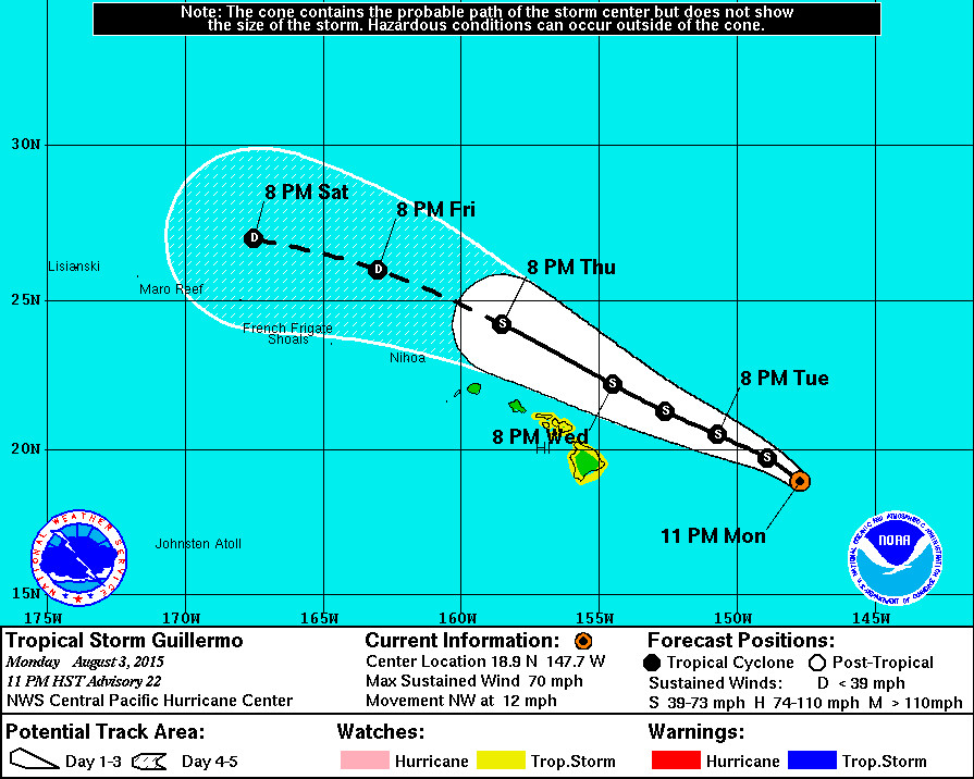
Tropical Storm Guillermo Update – 11 p.m.

- A Tropical Storm Watch is in effect for Hawaii Island, as well as the Islands of Maui, Molokai, Lanai and Kahoolawe. A Tropical Storm Watch means that tropical storm conditions are possible within the watch area, generally within 48 hours.
- As of 11 p.m. HST Tropical Storm Guillermo was 485 miles east of Hilo, Hawaii. The storm is moving northwest at 12 mph. The National Weather Service says the center of Guillermo is expected to pass 170 miles northeast of Hilo Wednesday afternoon and around 130 miles north of Maui Wednesday night.
- Tropical Storm Guillermo strengthened a bit since the 5 p.m. update. Maximum sustained winds are now measured at 70 mph with higher gusts. Little change in strength is expected through Wednesday morning, with slow but steady weakening anticipated thereafter. “It is not out of the question that Guillermo could become a hurricane over the next 12 hours,” NWS said in the 11 p.m. discussion (below).
- Total rainfall amounts of 1 to 3 inches are expected on Hawaii Island, with isolated maximum amounts near 7 inches mainly in higher terrain.
- A High Surf Advisory is now in effect for east facing shores of all islands.
National Weather Service – 11 p.m.
The latest infrared satellite presentation of Guillermo has improved since the last advisory…With persistent deep convection remaining near and to the northeast of the low level circulation center. It remains evident that Guillermo is undergoing quite a bit of westerly wind shear with the deep convection tilting the system off to the northeast… And this is shown well by the latest Uw-cimss vertical wind shear analysis indicating 20 knots of shear from 265 degrees. Despite the vertical wind shear present over the system… Dvorak classifications from PHFO… SAB… And JTWC continue to indicate t numbers of 3.5 or 55 knots. The final decision on the initial intensity was based heavily on timely data from the u.S. 53rd Weather Reconnaissance Aircraft which is currently sampling the inner core of Guillermo. The aircraft found max flight level winds of 72 knots… 33 nm northeast of the center of circulation. Adjusting the flight level winds to the surface yields surface winds of 58 mph. Additionally… SFMR data from the aircraft indicated surface winds as strong as 68 knots to the northeast of the center. Some of the SFMR winds may have been rainfall contaminated… And as a result… The initial intensity of Guillermo utilized a blend of the flight level and SFMR winds and was set at 60 knots… Just below Hurricane strength.
The initial position of the system was based on center fix positions from the reconnaissance aircraft as well… With an initial motion toward the northwest or 325 degrees at 10 knots. The latest model guidance shows the track shifting back slightly toward the left or closer to the Hawaiian Islands… But these models appear to be struggling with the current motion. The systems motion appears to be driven largely by a weakness in the mid-upper level ridge which extends from Guillermo off to the northwest to a location near 30n157w. This weakness in the ridge is driving the motion of Guillermo at the current time due to the deep convection in place near and to the northeast of the circulation center. As a result… The official forecast follows a direction on the north side of the guidance envelope through 24 hours which assumes maintenance of deep convection and interaction with the weakness in the mid-upper level ridge. Beyond 24 hours as westerly wind shear is forecast to increase significantly over the system… A shift toward the west-northwest is expected… Which is very close to the previous official forecast track. On this track… The closest approach of Guillermo remains well to the northeast of all the Hawaiian Islands… So the watch was maintained with this advisory package. If the track shifts back closer to the islands later tonight or Tuesday… A tropical storm warning may be needed for the Big Island or Maui County… But this is not anticipated at this time.
The intensity forecast for Guillermo is a blend of icon and hwrf intensity guidance along with weight given to the previous official forecast. The global models are showing the potential for decreasing vertical wind shear later tonight with a window of opportunity for strengthening possible through wednesday 05/18z. After 05/18z… Vertical wind shear is forecast to strengthen to 25 knots or greater over the system… And this should lead to steady weakening of the system thereafter. Given the potential for weakening of the shear along with favorable sea surface temperatures of around 82 degrees fahrenheit based on modis data from earlier this afternoon… It is not out of the question that Guillermo could become a hurricane over the next 12 hours. The official intensity forecast will show little change in strength however over the next 12 hours… Then show slow but steady weakening through 120 hours.
Another reconnaissance aircraft mission into Guillermo is scheduled for 12z Tuesday morning. The valuable data transmitted in real-time from these missions will help us to better determine the location… Intensity and size of the tropical storm… Along with any potential impacts to the Hawaiian Islands.

by Big Island Video News10:59 pm
on at
STORY SUMMARY
Tropical Storm Guillermo strengthened a bit since the 5 p.m. update. Maximum sustained winds are now measured at 70 mph with higher gusts. Little change in strength is expected through Wednesday morning, with slow but steady weakening anticipated thereafter.