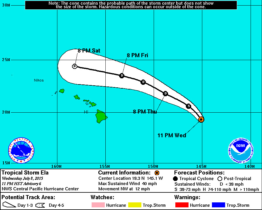
5 Day Track for ELA as of 11 p.m. July 8, courtesy the National Weather Service.
HONOLULU – Tropical Depression Four-E is now Tropical Storm Ela, but the storm is not expected to maintain that strength for long.
Tropical Storm Ela is 650 miles east of Hilo and is moving northwest at 12 miles per hour. Maximum sustained winds are 40 miles per hour.
There are no coastal watches or warnings in effect.
According to the National Weather Service discussion at 11 p.m.
Latest satellite imagery shows that persistent southwesterly shear has shunted the mid-level center of the cyclone well northeast of the surface center. However… Data from a U.S. Air Force Hurricane Hunter Aircraft indicate surface winds near 35 kt in the northeast quadrant. Although the on-board sfmr instrument was experiencing data quality issues… Reduction of flight level winds supports upgrading the depression to a tropical storm with this advisory.
The initial motion estimate is 320/10 kt… With Ela being steered by the flow around a deep layer ridge to the east… And a persistent closed low aloft centered just northeast of the main Hawaiian Islands. Uw-cimss indicates nearly 25 kt of southwesterly shear currently over the system… And ships guidance indicates increasing shear values along the forecast track… Especially after the first 24 hours or so. As such… Ela is forecast to maintain storm intensity overnight before succumbing to the shear and gradually weakening on Thursday and Friday. The increasingly shallow system is forecast to turn toward the west and dissipate to a remnant low just north of the main Hawaiian Islands this weekend… Before dissipation occurs. The updated track forecast has changed little… And lies between the previous and the tvcn consensus.

by Big Island Video News11:39 pm
on at
STORY SUMMARY
HONOLULU – Tropical Depression Four-E is now Tropical Storm Ela, but the storm is not expected to maintain that strength for long. Tropical Storm Ela is 650 miles east of Hilo and is moving northwest at 12 miles per hour. Maximum sustained winds are 40 miles per hour. There are no coastal watches or warnings […]