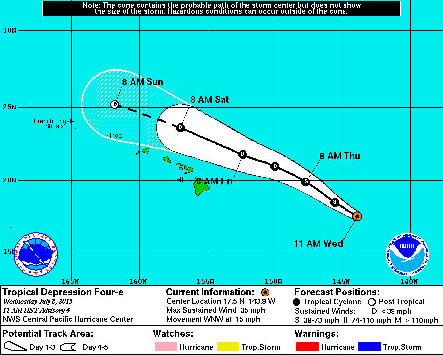
5 day track released by the National Weather Service at 11 p.m. HST
HAWAII ISLAND – The center of Tropical Depression Four-E is about 750 miles east of Hilo and heading west northwest at 15 miles per hour as of 11 p.m. HST. Four-E remains below tropical storm strength with sustained winds of 35 miles per hour. There are no watches or warnings in effect.
From the 11 p.m. National Weather Service discussion:
“Latest satellite imagery shows that the depression remains disorganized… Most likely due to persistent southwesterly shear in its vicinity. Air force recon… Visible imagery… And recent microwave passes helped in determining the position of the low-level center which lies just southwest of the deepest convection. Latest subjective dvorak intensity estimates range from 1.5 to 2.0. Since the system organization has not changed since the previous advisory… The initial intensity for this advisory has been maintained at 30 kt.” – National Weather Service at 11 pm on July 8, 2015
The National Weather Service reports that the depression is still forecast to strengthen during the next 24 hours, and could still become a tropical storm later today.
“Latest shear analysis from uw-cimss indicates 22 kt of south-southwesterly shear over the system. Most intensity guidance indicates that only a small window exists for the depression to intensify to tropical storm strength before the system succumbs to the impacts of increased southwesterly shear as indicated by ships guidance. The latest intensity forecast follows along with the previous forecast with the system strengthening to minimal tropical storm strength in 12 to 24 hours before weakening back to a depression in 36 to 48 hours. The system is expected to continue weakening to a post-tropical remnant low by day 4 and dissipated by day 5.” – National Weather Service at 11 pm on July 8, 2015
Nonetheless it is currently expected to pass to the north of the state and be of tropical depression strength by the time it reaches its closest point to the Big Island.
“The initial motion estimate is 298/13 kt which is slightly to the left of the previous forecast. The cyclone is tracking toward the west-northwest within the steering flow provided by a deep-layer ridge centered to the northeast and an upper low centered to the northwest of the system. This general motion is expected to continue for the next couple of days with little change from the previous forecast track. A bit more westward motion is expected toward the end of the forecast period as the system becomes increasingly shallow and becomes embedded in easterly trade wind flow south of a surface high centered far north of the Hawaiian Islands.” – National Weather Service at 11 pm on July 8, 2015

by Big Island Video News11:59 am
on at
STORY SUMMARY
HAWAII ISLAND – The center of Tropical Depression Four-E is about 750 miles east of Hilo and heading west northwest at 15 miles per hour as of 11 p.m. HST. Four-E remains below tropical storm strength with sustained winds of 35 miles per hour. There are no watches or warnings in effect. From the 11 […]