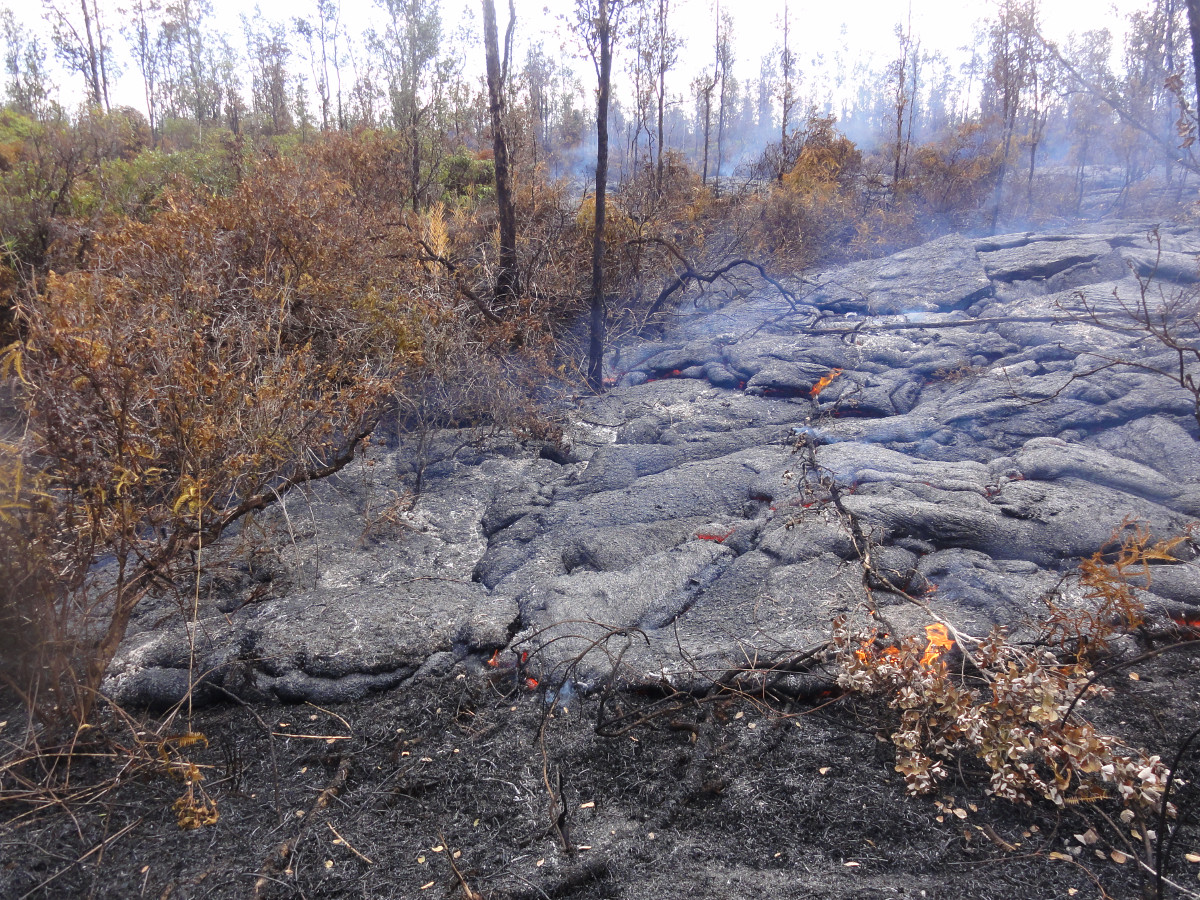
(ABOVE) This USGS Hawaiian Volcano Observatory photo shows small, sluggish breakouts on the leading tip of the flow, which has not advanced much recently. The flow remains 0.4 miles from Highway 130.
NEWS BRIEFS
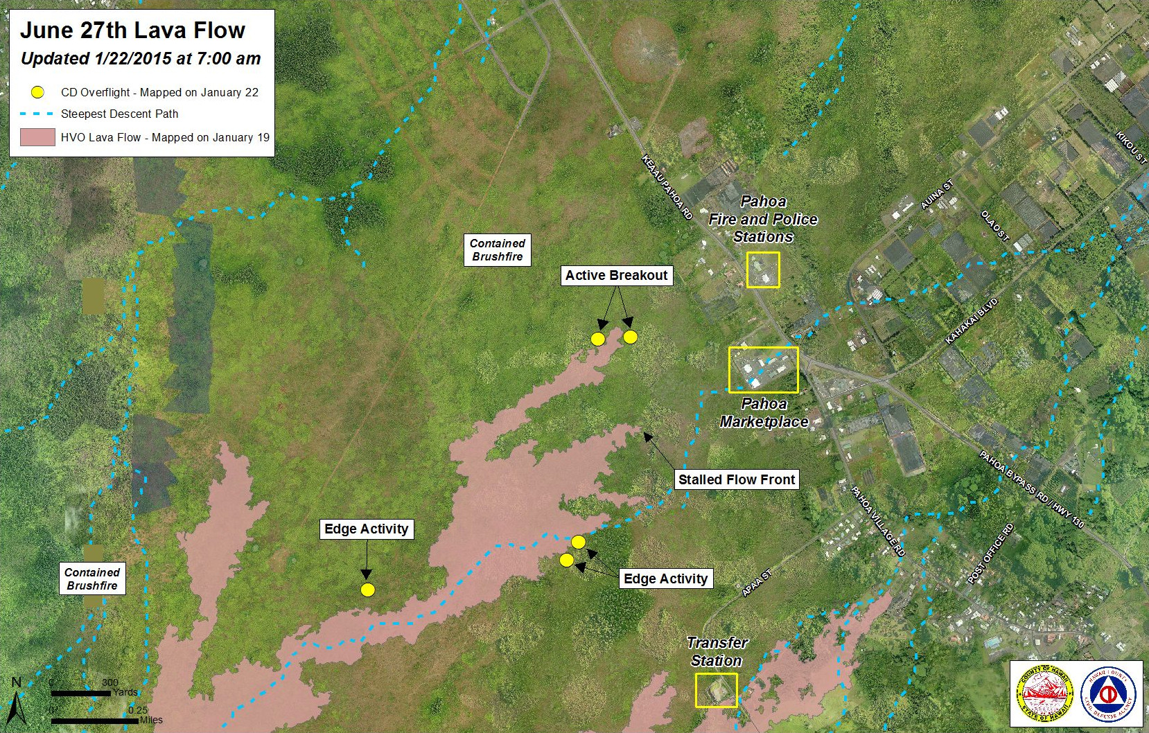
- The breakout along the north side of the flow continues to be active and is widening, however it has shown little sign of advancement since yesterday. A new civil defense map marks the areas of active breakouts on the margins of the lobe, which remains approximately 0.4 miles from the area of Highway 130 to the west or mauka of the Pahoa Police and Fire Stations. USGS notes some observations by civil defense put the flow a little under .4 miles (~600 meters) depending on how the measurement is taken.
- Lava related brush fire activity is contained within the fire break perimeters and there is currently no fire threat to area residents and properties. Hawaii Fire Department personnel and equipment remain on scene.
- Two active breakouts 1 to 1.5 miles upslope showed little activity and no signs of advancement. The lobe had entered a drainage area leading to the steepest-descent path that crosses Highway 130 about .6 miles south of the Makuʻu Farmer’s Market.
- There are breakouts along both margins of the flow and Civil Defense says all current activity does not pose an immediate threat to area communities.
- Smoke conditions were light to moderate with a light northwest wind blowing the smoke in a southeast direction.
LATEST MAP

Civil Defense Lava Flow Map – Updated Thursday, 1/22/15 at 7:00 am
RECENT RELATED VIDEO
PRIMARY SOURCES

This morning’s assessment shows that the original flow front and south margin breakout remain stalled. The breakout along the north side of the flow continues to be active and widening, however showing little signs of advancement since yesterday. The leading edge or front of this breakout remains approximately 0.4 miles from the area of Highway 130 to the west or mauka of the Pahoa Police and Fire Stations. Two other breakouts along the north margin located 1-1.5 miles further upslope or behind the flow front showed little activity and no signs of advancement. A number of other breakouts along both margins of the flow and within the flow pad were observed however all current activity does not pose an immediate threat to area communities. The Hawaii County Civil Defense Agency and Hawaiian Volcano Observatory are maintaining close observations of the flow. Residents and businesses down slope will be informed of any changes in flow activity and advancement.
Hawaii Fire Department personnel and equipment remain on scene and are monitoring the fire conditions. All fires that occurred are contained with the fire break perimeters and all burning activity is limited to hot spots and flare ups within the fire perimeters. There is currently no fire threat to area residents and properties.
Smoke conditions were light to moderate with a light southwest wind blowing the smoke in a northeast direction. Smoke conditions may increase in some areas and individuals who may be sensitive or have respiratory problems are advised to take necessary precautions and to remain indoors.
On behalf of the Hawaii County Civil Defense Agency and our partners we would like to thank everyone for your assistance and cooperation. Hawaii County Civil Defense on Jan. 22 at 7:30 a.m. HST

Kīlauea Volcano continues to erupt at its summit and within its East Rift Zone. In the East Rift Zone, the breakout that had become the leading edge of the June 27th lava flow was active, but has been moving sluggishly since January 17. Based on HVO and County Civil Defense observations, flows are not showing signs of appreciable daily advance, but sluggish breakouts are increasing flow widths. The leading edge remains approximately 600-650 m (0.4 mi) from Highway 130. Numerous breakouts were also active upslope and within the flow interiors. At Kīlauea summit, tilt measurements have leveled off after reaching values measured before the onset of the January 20 Deflationary-Inflationary cycling.
June 27th Lava Flow Observations: According to this morning’s report from Hawai`i County Civil Defense, the breakout from the June 27th lava flow that is furthest downslope was active, but had not advanced since yesterday. The tip was still about 650 m (0.4 mi) from the highway, in the vicinity of the fire and police stations. Civil Defense also reports numerous breakouts along both margins of the flow. HVO observations note that in places, the flow tip could be estimated at ~600 m from Highway 130.
The northern flow lobe that broke out from the main flow about 2.4 km (1.5 mi) upslope of the tip and advanced about 180 m (195 yd) from January 13 to January 19, continues to produce breakouts along the flow margins and within the flow field, but is not advancing.
Puʻu ʻŌʻō Observations: No significant changes are noted since yesterday in monitoring data streams from instruments deplolyed near Pu`u O`o. The most recent measurement of sulfur dioxide emissions from all East Rift Zone vents was about 200 tonnes per day on January 7.
Summit Observations: Summit inflation as part of the DI that began on January 20 has leveled off since reaching pre-DI levels yesterday. Halema`uma`u Overlook lava lake levels continue to fluctuate and the lava lake continues to spatter. The lava-lake level has not changed significantly over the past several days, and at ~1800h Hst yesterday, it was estimated to be about 47 m below the floor of Halemaʻumaʻu. Emission rate of sulfur dioxide ranged from around 4,500 to 7,600 tonnes/day during the week ending January 13.USGS Hawaiian Volcano Observatory on Jan. 22 at 9:24 a.m. HST

(USGS HVO photo on Jan. 21) Only a handful of small breakouts were active along the leading tip of the flow.

by Big Island Video News9:37 am
on at
STORY SUMMARY
The closest lobe to Highway 130 is active and widening but is not advancing much.