(ABOVE VIDEO) This morning’s Civil Defense message with video from a Saturday overflight courtesy Mick Kalber.
NEWS BRIEFS
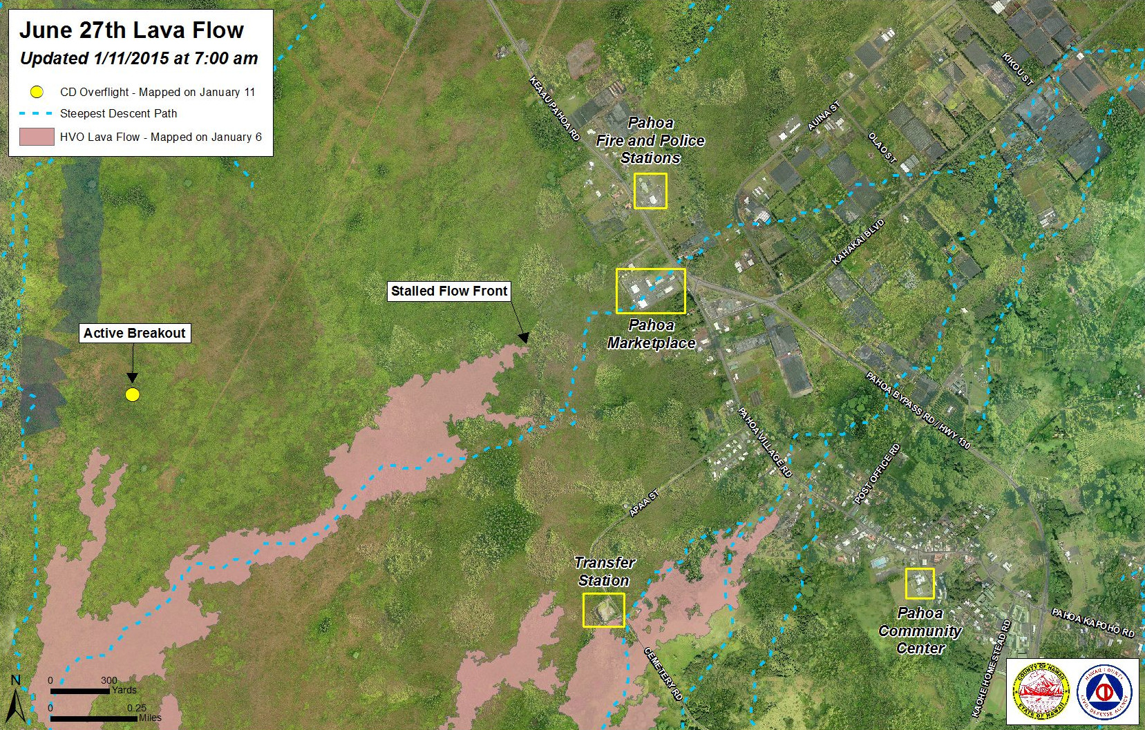
- The flow front remains stalled half a mile from Highway 130, but surface activity and widening continues 300 yards upslope.
- A large breakout on the surface of the flow pad a few hundred yards back from the leading edge was filmed yesterday at 8 a.m. by Mick Kalber during an overflight aboard Paradise Helicopters. The video shows the vigor of the activity not too far from the stalled front.
- Two breakouts picked up speed as they advanced 90 yards to the northeast since yesterday. The lobe is 1-1.5 miles behind the flow front, and has entered a drainage area leading to the steepest-descent path that crosses Highway 130 about .6 miles south of the Makuʻu Farmer’s Market. It is 2.1 miles upslope of the highway.
LATEST MAPS

Civil Defense Lava Flow Map – Updated Sunday, 1/11/15 at 7:00 am
PRIMARY SOURCES

This morning’s assessment shows that the flow front and south margin breakout remain stalled and there has been no advancement since last Friday. The front or leading edge remains 0.5 miles upslope of the Highway 130 and Pahoa Village Road intersection. Some surface activity and widening continues approximately 300 yards above or upslope of the flow front. Two breakouts along the north margin approximately 1-1.5 miles upslope or behind the flow front remain active and have advanced approximately 90 yards since yesterday in a northeast direction. Other surface breakouts and activity along both margins continues upslope however, current activity does not pose an immediate threat to area communities. Civil Defense and Hawaiian Volcano Observatory personnel are maintaining close observations of the flow. Residents and businesses down slope will be kept informed of any changes in flow activity, advancement, and status.
Smoke conditions were light to moderate with a light trade wind blowing the smoke in a southwest direction. Smoke conditions may increase in some areas and individuals who may be sensitive or have respiratory problems are advised to take necessary precautions and to remain indoors.
The hours of operation at the public lava viewing area at the Pahoa Transfer station have been adjusted effective this past Friday January 9th. The new hours of operation are from 10:00 am to 4:30 pm daily. This adjustment is based on the peak hours of visitation. We apologize for any inconvenience this change of operations may cause.
On behalf of the Hawaii County Civil Defense Agency and our partners we would like to thank everyone for your assistance and cooperation. Hawaii County Civil Defense on Jan. 11 at 7:30 a.m. HST

Kīlauea Volcano continues to erupt at its summit and within its East Rift Zone. In the East Rift Zone, the tip of the June 27th lava flow remained stalled; however, active surface breakouts up slope of the front continued. A narrow flow lobe about 2.5 km (1.6 mi) upslope of Pahoa Marketplace continued to advance toward the north-northeast. This morning, Civil Defense reported that this lobe has advanced about 80 m (90 yds) since yesterday. Very weak inflationary ground tilt was recorded over the past day at the summit and at Puʻu ʻŌʻō.
June 27th Lava Flow Observations: The flow that advanced toward Pahoa Marketplace in past weeks remained stalled approximately 800 m (0.5 miles or 880 yards) from the intersection of Highway 130 and Pāhoa Village Road; however, there were active breakouts about 275 m (300 ys) behind the stalled front this morning. In addition, the narrow flow lobe about 2.5 km (1.6 mi) upslope of Pahoa Marketplace advanced about 80 m (90 yds) toward the north-northeast since yesterday morning according to Hawai`i County Civil Defense. This lobe has entered a drainage area leading to the steepest-descent path that crosses Highway 130 about 1 km (0.6 mi) south of the Makuʻu Farmer’s Market, but the flow is still about 3.3 km (2.1 mi) uplsope from Highway 130 (straight-line distance to intersection of highway 130 and steepest descent line) and moving slowly. Other areas of surface lava were also active 0.9 – 3.5 km (0.5 – 2 mi) upslope of the Pahoa Marketplace during HVO’s most recent overflight on January 6. Breakouts further upslope, near the True/Mid-Pacific geothermal well pad, were also active.
Puʻu ʻŌʻō Observations: The tiltmeter on the north flank of Puʻu ʻŌʻō cone recorded very weak inflation over the past day. All other monitoring data indicated no significant changes at Puʻu ʻŌʻō. The most recent measurement of sulfur dioxide emissions from all East Rift Zone vents was about 250 tonnes per day on December 19, 2014.
Summit Observations: Very weak inflationary ground tilt was recorded at the summit over the past 4+ days. The summit lava lake has shown minor fluctuations associated with changes in spattering behavior, which are also manifested as variations in tremor amplitudes and gas release but no net change in level which was measured at around 48 m (160 ft) below the lip of the Overlook crater on January 6. Small amounts of particulate material were carried aloft by the plume. The average emission rate of sulfur dioxide was around 5,400 tonnes/day for the week ending on January 6.USGS Hawaiian Volcano Observatory on Jan. 11 at 8:03 a.m. HST

by Big Island Video News10:52 am
on at
STORY SUMMARY
Vigorous surface activity and widening continues 300 yards upslope of the stalled front.