(ABOVE VIDEO) Labelled USGS Hawaiian Volcano Observatory photo shows the distal part of the lava flow looking upslope from Pahoa.
NEWS BRIEFS
- The flow front remains stalled half a mile upslope of the Highway 130 and Pahoa Village Road intersection but breakouts remain active.
- The breakout along the north margin 1 to 1.5 miles behind the flow front remains active and has advanced in a north/northeast direction 75 yards since yesterday. USGS scientists say the lobe has entered a drainage that leads to the steepest-descent path that crosses Highway 130 about half a mile south of the Makuʻu Farmer’s Market, but the flow is still 2.2 miles uplsope from that point.
- The Railroad Avenue Alternate Access Road will be closed to all traffic effective 12:00 noon today.
MEDIA
Today’s civil defense message:
DETAILS
The flow front hasn’t advanced since Friday but breakouts behind it are getting lots of attention. Yesterday, the USGS Hawaiian Volcano Observatory conducted a helicopter overflight and mapped the perimeter of the June 27 lava flow. “At the time of the flight,” wrote scientists in a 6:42 p.m. (Jan. 6) status report, “surface breakouts along the distal part of the flow were scattered between 1 and 3.5 km (0.6 and 2.2 mi) upslope from the Pahoa Marketplace and posed no immediate threat.”
USGS HVO released new maps last night on their website.
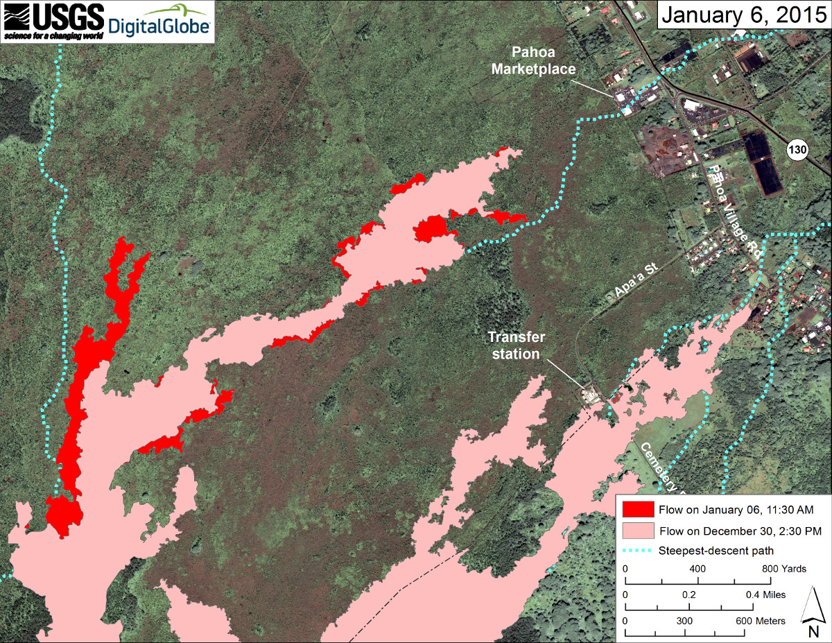
Satellite image of area around front of Kīlauea’s East Rift Zone lava flow by USGS HVO.
The map above shows the area of the flow on December 30 in pink, while widening and advancement of the flow since that time (mapped on January 6) is shown in red.
“The most active parts of the flow were in an area 400 to 900 m (440 to 980 yards) behind the stalled tip of the flow above Pahoa Marketplace,” wrote USGS, “and at the front of a flow lobe that branches off to the north about 3 km (2 miles) behind the stalled flow tip. Other active breakouts on the distal part of the flow were scattered between these two areas.”
There is also an area of persistent activity 4 miles upslope near the True/Mid-Pacific geothermal well site, which can be seen in this large-scale map of Kīlauea’s East Rift Zone lava flow, released on Jan. 6.
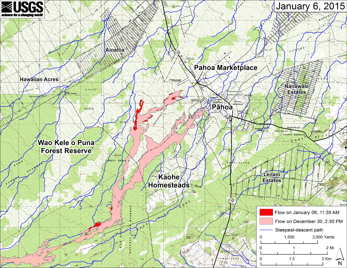
Large-scale map of Kīlauea’s East Rift Zone lava flow by USGS HVO,
Although it has not advanced, the leading edge of the flow front is still active, with activity 440 to 980 yards behind the stalled tip of the flow above Pahoa Marketplace. This image was posted to the USGS website last night.
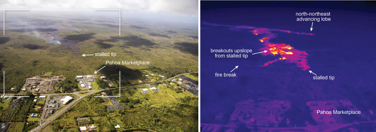
USGS Hawaiian Volcano Observatory photo on Jan. 6
(ABOVE) This shows a comparison of a normal photograph with a thermal image of the flow front. The white box shows the rough extent of the thermal image. White and yellow pixels in the thermal image show areas of active breakouts. Although the leading tip of the flow has stalled, the thermal image shows that active breakouts are present a short distance upslope of the stalled tip. USGS Hawaiian Volcano Observatory on Jan. 6
A lobe that branches off to the north about 2 miles behind the stalled flow tip is being watched closely. It has been unclear which direction this lobe may end up heading, and for the first time scientists discussed one possibility in last night’s status update.
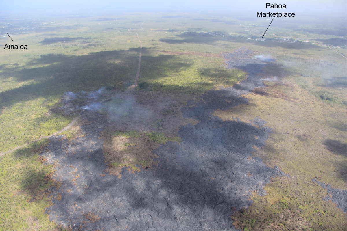
USGS Hawaiian Volcano Observatory photo on Jan. 6
(ABOVE) This view, looking northeast, shows the distal part of the flow, with the flow lobe behind Pahoa Marketplace to the right and the newer north-northeast advancing lobe to the left. The north-northeast lobe is following a drainage that leads to the steepest-descent path that crosses Highway 130 about 1 km (0.6 mi) south of the Maku`u Farmer’s Market. The flow, however, is still 3.5 km (2.2 mi) upslope from that spot and moving slowly. USGS Hawaiian Volcano Observatory on Jan. 6
Civil Defense reports this morning that the lobe has only advanced 75 yards since yesterday.
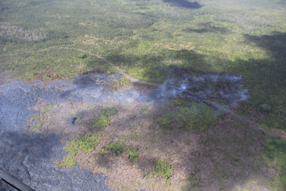
USGS Hawaiian Volcano Observatory photo on Jan. 6
This photo shows a closer view of the narrow north-northeast advancing lobe about 1.6 mi upslope from the Pahoa Markplace. The view is to the northwest. It has already crossed the firebreak.
PRIMARY SOURCES

This morning’s assessment shows that the flow front and south margin breakout remain stalled and there has been no advancement since Friday. The front or leading edge is located .5 miles upslope of the Highway 130 and Pahoa Village Road intersection. Some surface activity continues approximately 200 yards above or upslope of the flow front. Two breakouts along the north margin approximately 1-1.5 miles upslope or behind the flow front remain active and have advanced approximately 75 yards since yesterday in a north/northeast direction. Other surface breakouts and activity along both margins continues upslope however, current activity does not pose an immediate threat to area communities. Civil Defense and Hawaiian Volcano Observatory personnel are maintaining close observations of the flow. Residents and businesses down slope will be kept informed of any changes in flow activity, advancement, and status.
Smoke conditions were moderate this morning with a light north/northeast wind blowing the smoke in a southwest direction. Smoke conditions may increase in some areas and individuals who may be sensitive or have respiratory problems are advised to take necessary precautions and to remain indoors.
The Railroad Avenue Alternate Access Road will be closed to all traffic effective 12:00noon today, Wednesday January 7th. This closure is necessary to allow for road maintenance and to preserve the road until such time that it is needed. We appreciate everyone’s cooperation and understanding with this closure and assure the community that the alternate access roads will be opened well in advance of any threat or impact of the lava flow.
On behalf of the Hawaii County Civil Defense Agency and our partners we would like to thank everyone for your assistance and cooperation. Hawaii County Civil Defense on Jan. 7 at 8 a.m. HST

by Big Island Video News9:09 am
on at
STORY SUMMARY
The flow front remains stalled half a mile upslope of the Highway 130 and Pahoa Village Road intersection but breakouts remain active.