(ABOVE VIDEO) This morning’s Civil Defense message with overflight video courtesy the County of Hawaii.
NEWS BRIEFS
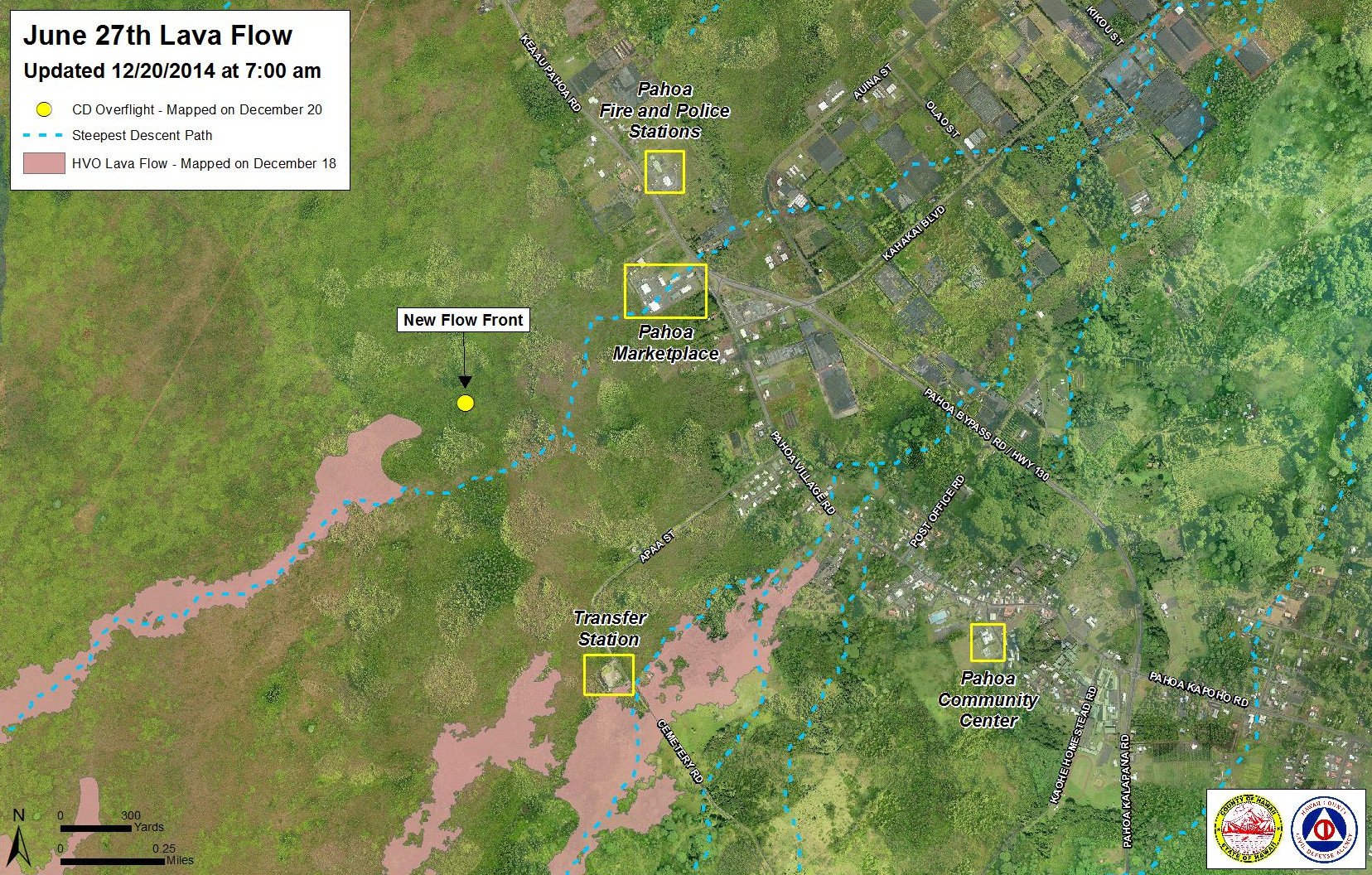
- Hawaii County Civil Defense reported this morning that the lava flow had advanced 160 yards since 6:30 a.m. yesterday morning and the front remains approximately 0.7 miles upslope of the Highway 130 and Pahoa Village Road intersection.
- In a morning update, USGS Hawaiian Volcano Observatory reported the distal tip of the active north branch of the flow front had narrowed to about 10 yards, while the stalled southern branch had numerous glowing cracks but just one breakout visible along its extent.
- Railroad Avenue opened at noon after a 10 a.m. blessing. Video coverage, including a real-time drivethrough, will be uploaded soon.
PRIMARY SOURCES

Kīlauea Volcano continues to erupt at its summit and within its East Rift Zone. A lava flow front consisting of north and south branches remains active, although the southern branch remains stalled as of this morning. The northern branch of the flow front has advanced ~150 m (~160 yds) since yesterday morning according to Civil Defense. An HVO ground crew this morning located the leading edge of this front at 1.0 km (0.6 miles) above the intersection of Pāhoa Village Road and Highway 130, near the Pāhoa Marketplace. A small summit deflation event that began Friday afternoon appears to have turned around as of this morning. No significant tilt has been observed at Puʻu ʻŌʻō since yesterday’s report.
June 27th Lava Flow Observations: HVO, along with Civil Defense, is monitoring a flow front that branches off the west edge of the flow field below the crack system. Civil Defense reported this morning that the leading edge of the active flow had advanced about 150 m (160) yards since their Friday morning flight. This morning’s HVO ground crew reported that the active flow tip was 1.0 km (0.6 miles) upslope from the intersection of Pāhoa Village Road and Highway 130, near the Pāhoa Marketplace. Yesterday’s HVO ground crew reported that after spreading out in relatively flat terrain on Wednesday and Thursday, the active tip of the north branch had narrowed to about 10 meters (10 yards). The descent path of this branch, if it continues to be followed, will take the flow to the Pāhoa Marketplace. Yesterday’s observations also showed that the southern branch of the active flow front remained stalled, with numerous glowing cracks but just one breakout visible along its extent. In addition to the active northern flow front, breakouts from the lava tube on December 5, about 2.6 km (1.6 mi) from Puʻu ʻŌʻō remained active as of Thursday’s HVO overflight.
Puʻu ʻŌʻō Observations: No significant change in ground tilt has been observed in the past 24 hours, and overall for the last week ground tilt measured at the cone has been minor and deflationary. All other monitoring data indicate no significant changes at Puʻu ʻŌʻō. Seismic tremor is low and steady, and webcams revealed no strong variations in the pattern of glow from degassing vents or the configuration of the crater floor. GPS-measured deformation across the cone has shown no net extension nor contraction since July. The most recent measurement of sulfur dioxide emissions from the East Rift Zone was about 300 tonnes per day on December 11, 2014.
Summit Observations: A tiltmeter at Kīlauea’s summit recorded a deflation/inflation event beginning yesterday at around 12:45 pm, with inflation restarting at about 7:30 this morning. The summit lava lake has shown the usual fluctuations associated with changes in spattering behavior, which are also manifested as variations in tremor amplitudes and gas release. Small amounts of particulate material were carried aloft by the plume. The average emission rate of sulfur dioxide ranged between 3,100 and 6,500 tonnes/day for the week ending on December 16USGS Hawaiian Volcano Observatory on Nov. 27 at 9:13 a.m. HST


by Big Island Video News3:32 pm
on at
STORY SUMMARY
New video taken this morning shows the active flow front approaching Pahoa Marketplace.