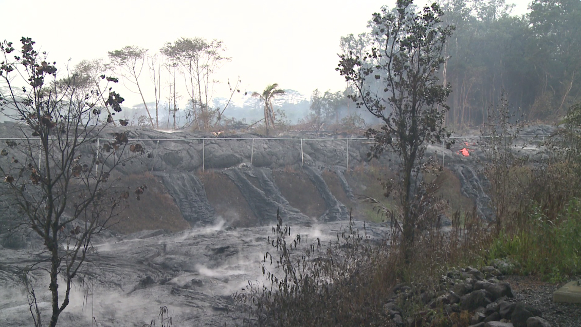
(ABOVE VIDEO) This morning’s Civil Defense message with video from the air by Mick Kalber and footage from the ground courtesy the County of Hawaii.
NEWS BRIEFS
- Civil defense is watching several active breakouts on the flow field located in the area of the cemetery below Apa’a Street, above Apa’a Street upslope of the transfer station, and 300 yards upslope of Apa’a Street.

The scene at the transfer station on Friday, courtesy the County of Hawaii.
INSIGHT
In the eruption information update issued this morning, civil defense reported that the lava breakout near the transfer station had stopped flowing and was not active. Video distributed by the County of Hawaii did show some breakouts burning through the transfer station fence. In the evening update, there was no mention of the stalled transfer station flow. It should be noted that the audio in the video above comes from the Friday morning civil defense message. A new message was issued after it was posted.
PRIMARY SOURCES

This afternoon’s assessment shows that several breakouts remain active and continue to advance. The active breakouts are located in the area of the cemetery below Apa’a Street; above Apa’a Street in the area west or upslope of the transfer station; and 300 yards upslope of Apa’a Street. The breakouts currently do not pose an immediate threat to area residents and will be monitored closely. All burning with breakouts is currently limited to vegetation only.
Smoke conditions remain moderate to heavy with a light south wind blowing the smoke in a north northeast direction towards the Ainaloa, Hawaiian Paradise Park and Keaau areas. Smoke conditions may increase in some areas and residents down wind that may be sensitive or have respiratory problems are advised to take necessary precautions and to remain indoors. The weather service has forecasted continued south winds for the next few days.
The evacuation advisory for those residents down slope of the flow will continue and residents will be kept informed of the flow status and advancement.
The Pahoa Village Road between Apa’a Street and the Post Office Road will remain closed and limited to area residents only. Access to the businesses and commercial areas of the Pahoa town can be made through the Pahoa Village Road at the intersection of Highways 130 and 132 and the Post Office Road. We apologize for any inconvenience the road closure may be presenting with and remind everyone that the Pahoa town center and businesses are open and accessible.
Civil Defense and public safety personnel will be operating in the area round the clock to maintain close observations of flow activity.
Additional updates will be broadcasted as conditions change. Hawaii County Civil Defense on Nov. 14 at 6:15 p.m. HST
When the USGS Hawaiian Volcano Observatory releases their evening update, we will share that information here:

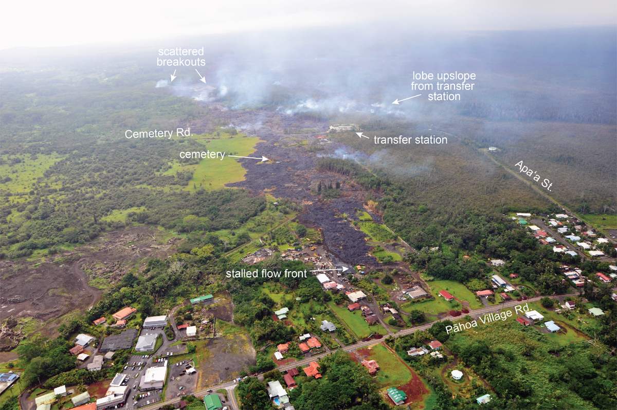
Scientists of the USGS Hawaiian Volcano Observatory conducted an overflight of the June 27th lava flow earlier today, November 14, 2014. A few small breakouts were active below Apa`a St./Cemetery Rd., a short distance north of the cemetery. The closest active breakouts to Pāhoa Village Road were approximately 700 meters (0.4 miles) upslope of the road.
The majority of breakouts were active upslope of Apa`a St./Cemetery Rd. Breakouts remained active in a lobe that is upslope of the transfer station, and the leading tip of this lobe was 230 meters (250 yards) upslope of Apa`a St. This lobe has advanced about 100 m (110 yds) over the past day, and widened about 80 m (90 yd) towards the east. Additional breakouts were active up to 2.7 km (1.7 miles) upslope of Apa`a St.
A breakout was also active about 5 km (3 mi) downslope from Puʻu ʻŌʻō.
Daily updates about Kīlauea’s ongoing eruptions, recent images and videos of summit and East Rift Zone volcanic activity, and data about recent earthquakes are posted on the HVO Web site at http://hvo.wr.usgs.gov.USGS Hawaiian Volcano Observatory on Nov. 14 at 8:44 p.m. HST

USGS HVO overflight photo taken on Nov. 14 with breakouts and other features labelled.

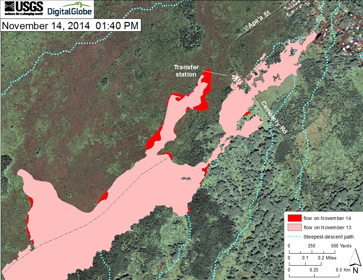
This USGS HVO map uses a satellite image acquired in March 2014 (provided by Digital Globe) as a base at 1:13,000 scale to show the area around the front of the June 27th lava flow. The area of the flow as mapped on November 12 and 13, 2014, is shown in pink, while widening and advancement of the flow as mapped on November 14, at 1:40 PM is shown in red.

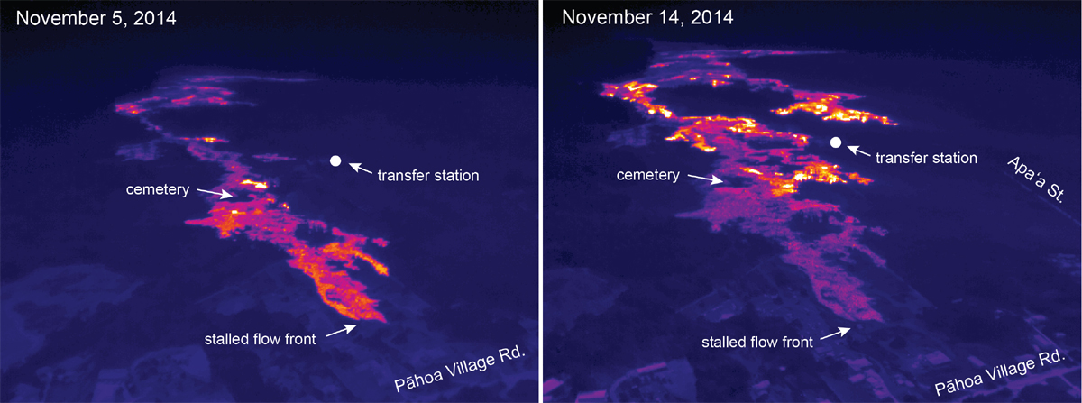
These thermal images, produced by USGS HVO, compare activity around the flow front on November 5 and 14, 2014. White and yellow colors show areas of active breakouts. On November 5 relatively few breakouts were active in this portion of the June 27th flow, with a few small breakouts near the cemetery and one breakout a few hundred meters upslope of the transfer station. On November 14, however, scattered breakouts were abundant in this area, with new activity significantly expanding the flow margins around the cemetery and a new lobe active upslope of the transfer station.

by Big Island Video News6:15 pm
on at
STORY SUMMARY
Civil defense continues to watch several active breakouts on the flow field.