(ABOVE PHOTO) Active lava by a Pahoa ginger patch, image courtesy Hawaii County
NEWS BRIEFS
- The lava flow remains active but has not advanced since 6:30 a.m. this morning. The front area – currently 60 yards across – has shown signs of widening with breakouts along the margins.
- Civil defense reports a new breakout located upslope from the flow front on the north side is active and advancing in a northeast direction, and will be monitored closely.
PRIMARY SOURCES

The flow continues to remain active however has not advanced since 6:30 this morning, the front area has shown signs of widening with breakouts along the flanks or margins. Currently the flow front is approximately 60 yards wide. The flow front is currently 480 feet from Pāhoa Village Road. A new breakout located upslope from the flow front on the north side is active and advancing in a northeast direction and will be monitored closely.
Smoke conditions continue to be moderate with moderate trade winds from the northeast pushing the smoke in a south southwest direction. Presently burning activity is involving a variety of materials and smoke conditions may increase in some areas. Residents down wind that may be sensitive or have respiratory problems are advised to take necessary precautions and to remain indoors. Additional health advisories may be issued depending upon materials involved with any fires associated with the lava flow.
Based on the current flow location, direction and advancement, residents in the flow path were placed on an evacuation advisory and notified of possible need for evacuation. The evacuation advisory for those residents down slope of the flow will continue and residents will be kept informed of the flow status and advancement.
The Pahoa Village Road between Apa’a Street and the Post Office Road will remain closed and limited to area residents only. Motorist should use caution and slow down on Highway 130 near the Post Office Road intersection. Residents of the restricted area should not bring unauthorized persons into the restricted area. In addition, Civil Defense and public safety personnel will be operating in the area round the clock to maintain close observations of flow activity. Additional updates will be broadcasted as conditions change.Hawaii County Civil Defense on Oct. 30 at 2:45 p.m. HST

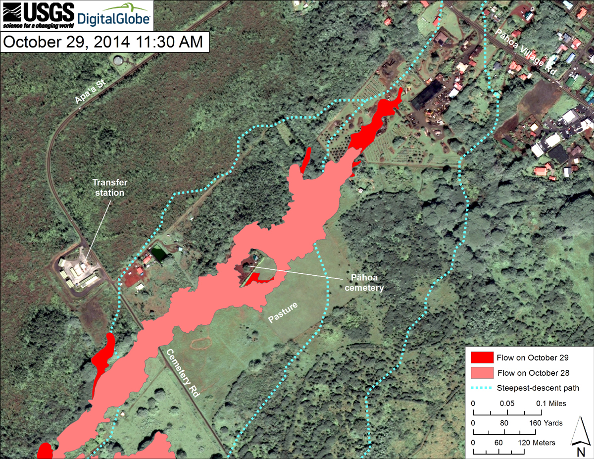
USGS HVO: This map uses a satellite image acquired in March 2014 (provided by Digital Globe) as a base to show the area around the front of the June 27th lava flow. The area of the flow on October 28, 2014, at 1:00 PM is shown in pink, while widening and advancement of the flow as mapped on October 29 at 11:30 AM is shown in red. The dotted blue lines show steepest-descent paths in the area, calculated from a 1983 digital elevation model (DEM).
The flow advanced about 170 meters (185 yards) during the preceding 22.5 hours, traveling through private property. The flow was 215 meters (235 yd) upslope from Pāhoa Village Road at the time of mapping. A crudely mapped finger was also active just outside the same private property along the north side of the flow.
Flow inflation over the past several days has lifted the flow surface higher than the old cane field berm just upslope from Apaʻa Street. Two new breakouts from along the north edge of the flow started yesterday and overtopped the berm. Though not large, the more vigorous of the two breakouts was following the previously projected steepest-descent path that passes just east of the transfer station.

by Big Island Video News
on at
STORY SUMMARY
Lava has not advanced since this morning but is still active and appears to be widening.