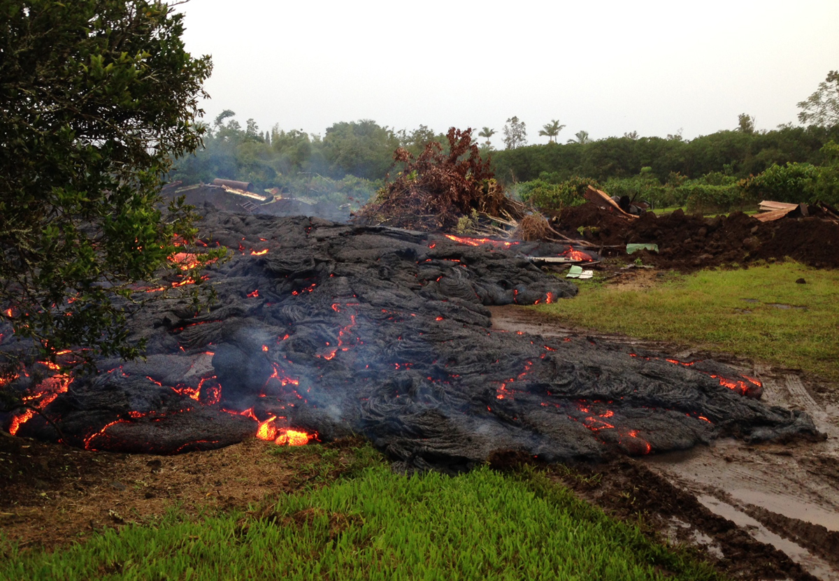
(ABOVE PHOTO) The lava continues to advance downslope in a northeast direction. This photo was taken October 28, and is courtesy ‘Ena Media Hawai’i/Blue Hawaiian Helicopters.
(ABOVE VIDEO) Wednesday morning’s Hawaii County Civil Defense message, with video provided by Hawaii County filmed on October 28, and some shots around town by David Corrigan.
NEWS BRIEFS
- The lava flow has advanced 90 yards since 6:30 p.m. HST and is currently 280 yards from Pāhoa Village Road. The flow front is moving in a northeast direction at 10 yards per hour. It has entered a private residential property.
- Smoke conditions are moderate. Residents down wind are advised to take necessary precautions and to remain indoors.
PRIMARY SOURCES

The flow continues to remain active and has advanced approximately 90 yards since this 6:30PM last night and is currently approximately 280 yards from Pāhoa Village Road. The flow front is currently moving in a northeast direction and has entered a private residential property. The flow advancement has been averaging approximately 10 yards per hour.
Smoke conditions were moderate with moderate trade winds from the northeast pushing the smoke in a south southwest direction. Presently burning activity is involving a variety of materials to include tires and smoke conditions may increase in some areas. Residents down wind that may be sensitive or have respiratory problems are advised to take necessary precautions and to remain indoors. Additional health advisories may be issued depending upon materials involved with any fires associated with the lava flow.
Based on the current flow location, direction and advancement, residents in the flow path were placed on an evacuation advisory and notified of possible need for evacuation. The evacuation advisory for those residents down slope of the flow will continue and residents will be kept informed of the flow status and advancement.
The Pahoa Village Road between Apa’a Street and the Post Office Road will remain closed and limited to area residents only. Motorist should use caution and slow down on Highway 130 near the Post Office Road intersection. Residents of the restricted area should not bring unauthorized persons into the restricted area. In addition, Civil Defense and public safety personnel will be operating in the area round the clock to maintain close observations of flow activity. Additional updates will be broadcasted as conditions change.Hawaii County Civil Defense on Oct. 29 at 8:15 a.m. HST

Kīlauea continues to erupt at its summit and within its East Rift Zone, and gas emissions remained elevated. Currently, the June 27th flow is advancing northeast through a residential area between Apaʻa St/Cemetery Rd and Pāhoa Village Road. During the past 24 hours, the leading edge of the most rapidly advancing part of the flow advanced at an average rate of roughly 10 m/hr (~11 yd/hr); between 2am and 630 am this morning, the rate of advance slowed to roughly 5 m/hr (~5.5 yd/hr). At 7AM, the flow front was about 240 m (~260 yd) straight-line distance from Pāhoa Village Road.
June 27th Lava Flow Observations: HVO scientists monitored the leading portions of the June 27th flow on the ground throughout the day and night. The most rapidly advancing lobe of the flow continues to advance northeast towards Pāhoa Village Road through the first residential parcel it entered, currently at a rate of 5 m/hr (~5.5 yd/hr). If the flow continues in this manner, we expect it to cross Pahoa Village Road between Apaʻa St and Post Office Road.
A few breakouts continue to occur upslope of the leading flow lobe within about 3 km (1.9 miles) of the flow front. Scientists are currently monitoring the flow front and will issue a status update this afternoon.
Puʻu ʻŌʻō Observations: Small changes in ground tilt were recorded at Puʻu ʻŌʻō during the past day. Seismic tremor remained steady. Glow was visible overnight above several outgassing openings in the crater floor, but there were no significant changes in activity within the crater.USGS Hawaiian Volcano Observatory on Oct. 29 at 9:12 a.m. HST
This USGS Hawaiian Volcano Observatory photo from 6:30 a.m., HST, on Wednesday, October 29, 2014, shows lava from the June 27th flow continuing to move downslope through the property it entered the previous morning.
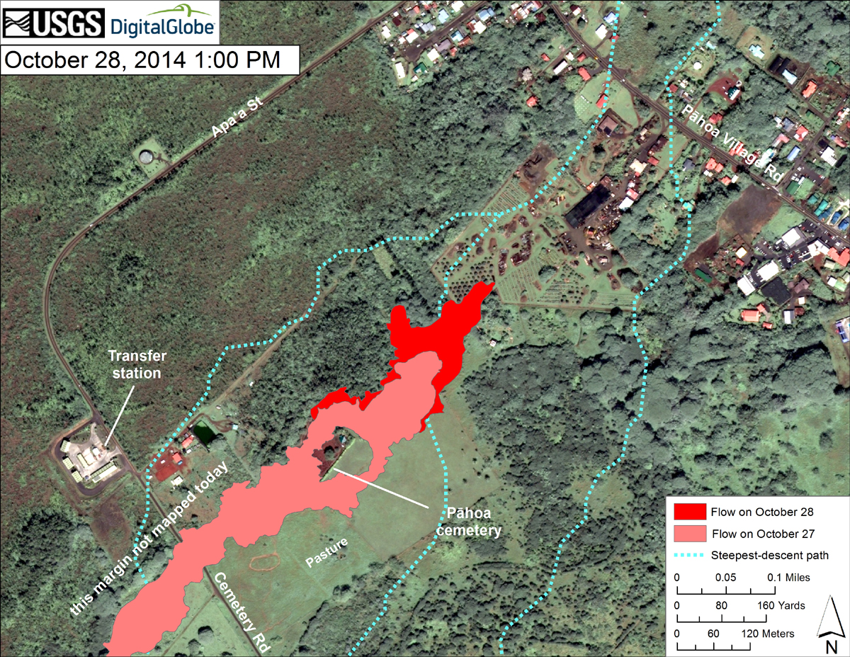
This USGS HVO map uses a satellite image acquired in March 2014 (provided by Digital Globe) as a base to show the area around the front of the June 27th lava flow. The area of the flow on October 27, 2014, at 11:30 PM is shown in pink, while widening and advancement of the flow as mapped on October 28 at 1:00 PM is shown in red. The mapping today was focused on the immediate flow front region, and did not cover the western margin of the flow near Apaʻa St. (see marked margin). Also, another lobe upslope of Cemetery Rd. is not shown in this map, but it only advanced about 30 m (33 yards) over the past day. The dotted blue lines show steepest-descent paths in the area, calculated from a 1983 digital elevation model (DEM).
The flow advanced about 150 meters (164 yards) between these two mapping times, and was advancing through private property this afternoon. At the time of mapping (1 PM), the flow was 390 meters (430 yards) directly upslope from Pāhoa Village Road. The latitude and longitude of the front as of 1 PM was 19.49412, -154.95378 (Decimal Degrees; WGS84). Though not shown on this map, the flow front advanced an additional 70 meters (77 yards) by 5:30 PM.

by Big Island Video News
on at
STORY SUMMARY
The lava flow continues moving at 10 yards per hour and is currently 280 yards from Pāhoa Village Road.