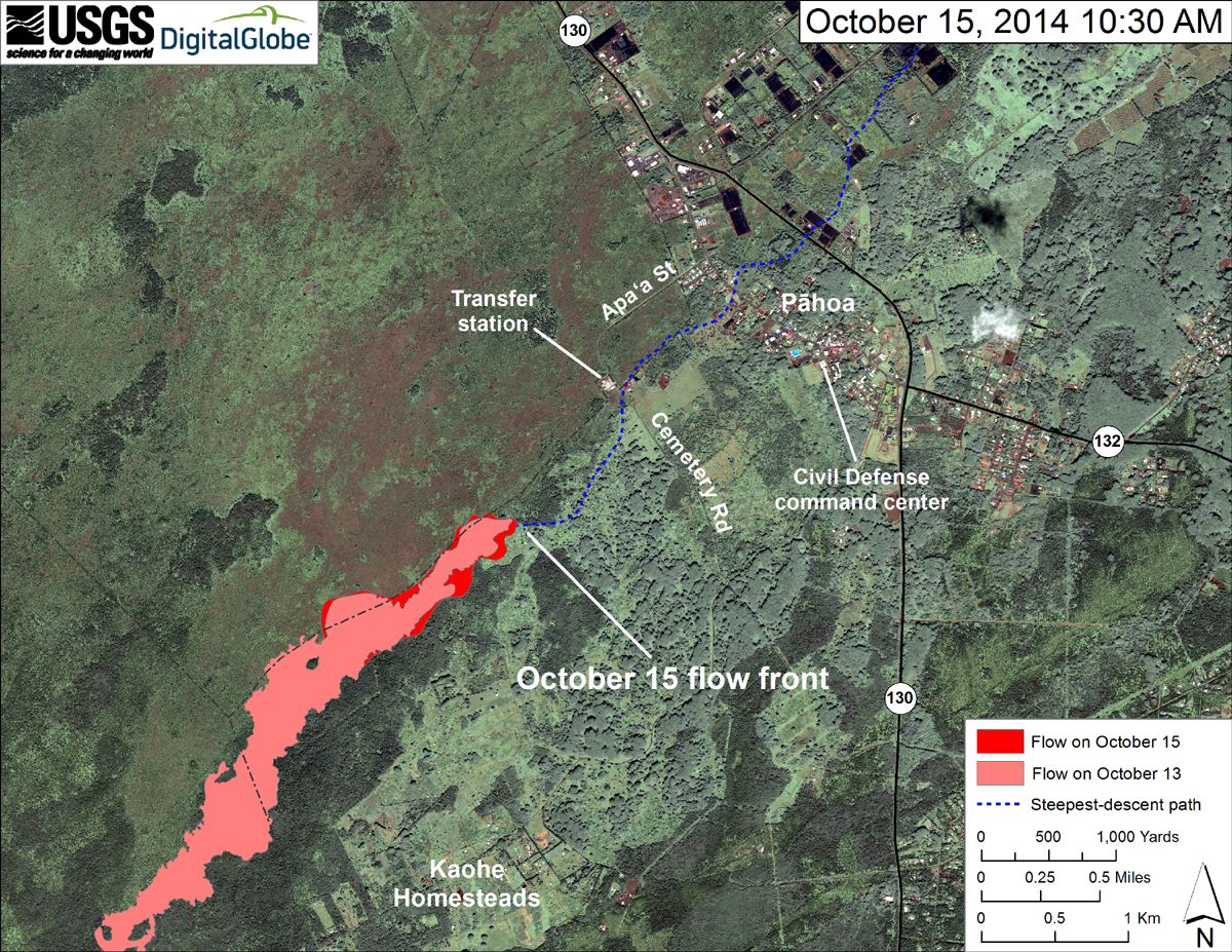
(ABOVE PHOTO) A closer view of the leading edge of the flow courtesy the USGS Hawaiian Volcano Observatory, which yesterday consisted of scattered breakouts along the flow margin that were slowly moving through thick vegetation.
NEWS BRIEFS
- Civil Defense reports the flow front appears to have stalled and has not advanced since yesterday.
- Smoke conditions were light to moderate this morning with light winds out of the northeast.
PRIMARY SOURCES

This morning’s assessment shows that the flow front appears to have stalled and has not advanced since yesterday. The flow front remains approximately 0.6 miles from the Apa’a Street area near the Pahoa Transfer Station. All burning activity is limited to the vegetation that is in direct contact with the flow and there is no brush fire threat at this time. Smoke conditions were light to moderate this morning with light winds out of the northeast.
Current flow activity does not pose an immediate threat to area communities and no evacuation is needed at this time. Area residents will be given adequate notice to safely evacuate should that be necessary.
The public is reminded that the flow is not visible and cannot be accessed from any public areas. Access to the Kaohe Homesteads subdivision will remain restricted to area residents only.Hawaii County Civil Defense on Oct. 16

The June 27th lava flow remains active, but the flow front has stalled. Small breakouts, however, remain scattered across the surface and along the edges of the flow up to about 2 km (1.2 miles) back from the front. The flow width ranges from 200 to 500 m (220 to 550 yards) over this distance. Most breakouts were found within this part of the flow during an overflight yesterday morning (October 15). The flow front at that time was about 1.3 km (0.8 miles) from Apaʻa St/Cemetery Rd, as measured along the steepest-descent line that the flow has been following.
Breakouts are also active roughly mid-way along the length of the flow, just upslope from the area where lava enters and travels within ground cracks. Breakouts have persisted in this area for several weeks, but the number of breakouts and overall level of activity has fallen over the past week.
Puʻu ʻŌʻō Observations: No significant change in eruptive activity or ground tilt was recorded at Puʻu ʻŌʻō over the past day. Seismic tremor has been low and relatively constant. Glow was visible overnight above several outgassing openings in the crater floor. The most recent sulfur-dioxide emission-rate measurement for the East Rift Zone was 450 tonnes per day (from all sources) on October 9, 2014.
Summit Observations: Deflation of the summit slowed through the day yesterday and overnight, and switched to slow inflation shortly before sunrise this morning. The lava lake level fell with the deflation to roughly 65 m below the rim of the Overlook crater (the floor of Halemaʻumaʻu), where it remains this morning.
There has been an increase in deep tremor south of Pāhala over the past week. This is a common source area for tremor, and is associated with the deepest root of Kīlauea’s plumbing system. It is not related to the recent magnitude 4.0 earthquake near Nāʻālehu, and past occurrences of tremor in this area have not been correlated with changes in Kīlauea’s eruptive activity.USGS Hawaiian Volcano Observatory on Oct. 12

Satellite image of area around flow front, posted by USGS Hawaiian Volcano Observatory on October 15th.

by Big Island Video News8:14 am
on at
STORY SUMMARY
The flow front appears to have stalled and has not advanced since yesterday.