(ABOVE VIDEO) Hawaii County Civil Defense message issued Thursday morning, with photos, maps and video by USGS Hawaiian Volcano Observatory
NEWS BRIEFS
- The breakout that moved ahead of the flow front has advanced 100 yards since Wednesday.
- There is scattered activity along the lava perimeter and there was some burning in the forest on the southeast edge of the flow front. There was moderate to heavy smoke, but no brushfire.
PRIMARY SOURCES

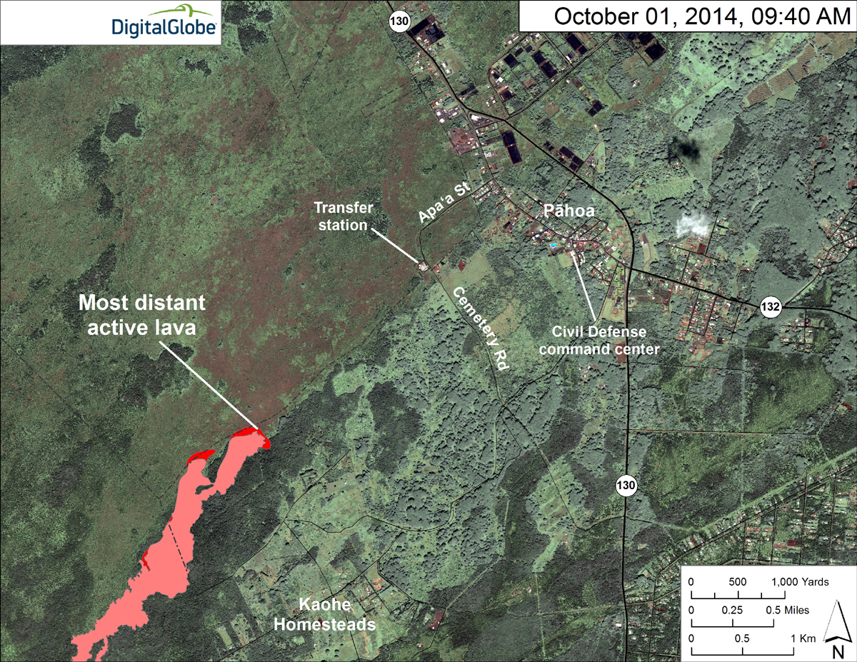
Due to an ongoing emergency search and rescue mission, today’s helicopter assessment was delayed. An aerial survey performed later this morning shows that the breakout has advanced ahead of the original flow front and has moved approximately 100 yards since yesterday. Scattered lava activity was noted along the perimeter and some burning was noted along the forest line area on the southeast edge of the flow. This burning activity is resulting in moderate to heavy smoke conditions in the area however there is no brush fire threat at this time.
The active flow does not pose an immediate threat to area communities and no evacuation is needed at this time.
The Railroad Emergency Route is NOT open to the public at this time. The public is reminded that no public vehicles, persons, or activity is allowed within the emergency route until the route is opened. The route will be opened for use upon the direction of Civil Defense in the event HWY 130 is unusable due to the lava flow.
HELCO crews are continuing with work in the Government Beach road area. This will result in the road being blocked and the access will be limited to beach road residents only to minimize disruption and delays to the operations.
The public is reminded that the flow is not visible and cannot be accessed from any public areas. Access to the Kaohe Homesteads subdivision will remain restricted to area residents only.Hawaii County Civil Defense on Oct. 2

The June 27th lava flow remains active. An HVO overflight yesterday morning observed that the slow-moving breakout behind the stalled front had reached the front and extended the leading edge of the flow about 30 m (100 ft). Surface flows remained active upslope of the flow front, with continued scattered breakouts in the area that lava first entered the crack system about 8 km (5 mi) behind the stalled front.
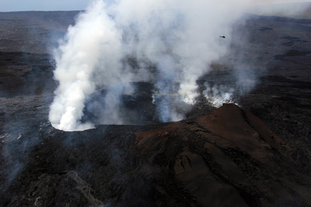
Puʻu ʻŌʻō Observations: There was little net change in ground tilt at Pu’u O’o over the past day. Glow was visible overnight above several outgassing openings in the crater floor. A small lava flow was erupted from a pit on the southeast side of the crater early this morning. The most recent sulfur-dioxide emission-rate measurement for the East Rift Zone was 550 tonnes per day (from all sources) on September 25, 2014. Seismic tremor is low and constant.
Summit Observations: There has been inflationary tilt at the summit over most of the past day. The lava level within the summit vent rose accordingly to about 42 m below the Overlook crater rim. There was an increase in long period seismicity in the caldera and increasing seismicity in the upper east rift, both consistent with inflation in the summit. Seismic tremor at the summit varied with changes in spattering on the surface of the lava lake but overall remained low. GPS receivers spanning the summit caldera recorded about 5 cm (2 in) of extension between early May and early July. Since then, little significant extension or contraction has occurred.USGS Hawaiian Volcano Observatory on Oct. 2

USGS HVO: This map uses a satellite image acquired in March 2014 (provided by Digital Globe) as a base to show the area around the front of the June 27th lava flow. Surface activity near the flow front was advancing slowly northeast in two lobes. The active lobe farthest from the vent (the closest to Pāhoa) has now overtaken the stalled front and extended it by about 30 m (33 yards). It traveled about 150 m (273 yards) since Monday, September 29. A second lobe was about 450 m (492 yards) back from the stalled front, and it moved only about 140 m (153 yards) since Monday.

Activity in Puʻu ʻŌʻō Crater has remained relatively similar over the past several weeks. Small lava ponds and incandescent holes are present in several pits on the crater floor. (USGS HVO)

by Big Island Video News12:53 pm
on at
STORY SUMMARY
The breakout that moved ahead of the flow front has advanced 100 yards since Wednesday.