(ABOVE PHOTO) The June 27 flow moving to the northeast, with Kaohe Homesteads in the foreground. Courtesy USGS Hawaiian Volcano Observatory
PUNA, Hawaii – In a Friday evening map and photo update, the USGS Hawaiian Volcano Observatory reports that the lava flow continues moving in the same northeast direction that it assumed in the middle of the week. It has nearly reached the boundary of the Kaohe Homesteads community (.1 miles away as of noon.)
The flow is still within thick forest, “so that dense plumes of smoke are created as vegetation is consumed,” writes USGS.
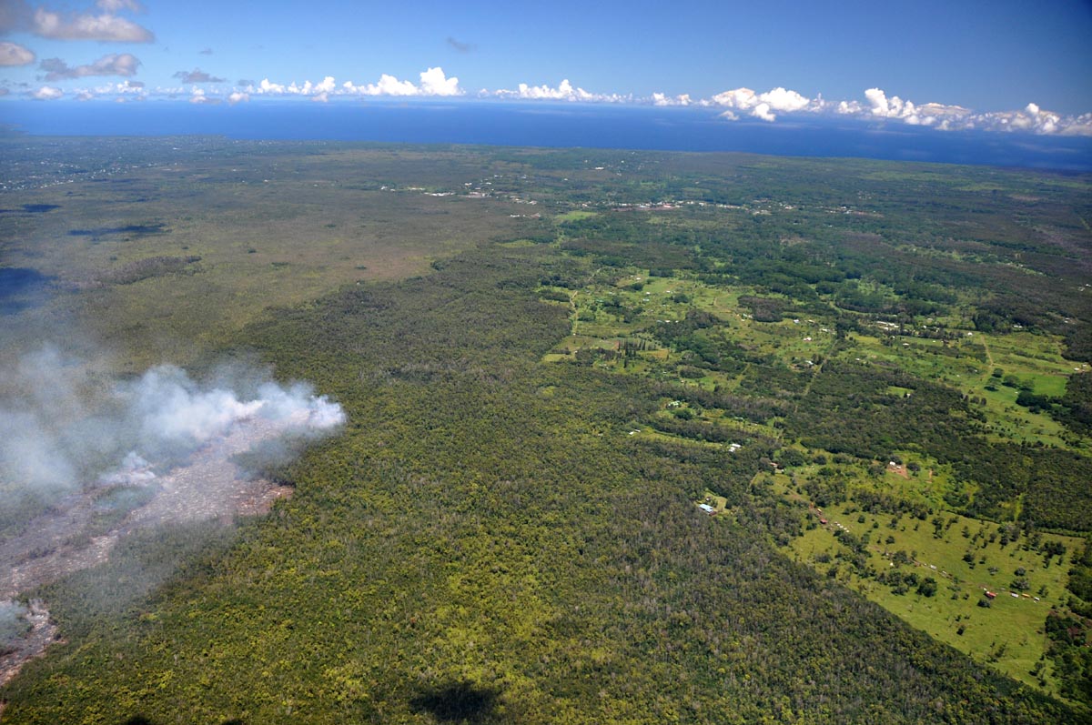
USGS HVO: “View looking northeast along the terminus of the July 27th flow. Kaohe Homesteads is to the right, and Pāhoa town is in the middle center. The active flow is in the middle left.”
Authorities are closing Wao Kele o Puna Forest Reserve, until further notice. The Office of Hawaiian Affairs, which owns the forest reserve, and the Department of Land and Natural Resources which manages the land made the announcement on Friday. The agencies blamed the hazards associated with the June 27 lava flow.
OHA Chief Executive Officer Kamana‘opono Crabbe said, “It is prudent at this time to close Wao Kele o Puna due to lava activity and subsequent unsafe conditions.”
DLNR Chair William J. Aila, Jr. said, “We join with Hawaii Civil Defense and Hawaii Volcanoes National Park to warn the public of extreme danger from lava flowing through cracks in Wao Kele O Puna, and Kahauale’a Natural Area Reserve. Both areas are off-limits to all persons. We will prosecute anyone entering these areas for any purpose, including unauthorized lava sightseeing tours. Hikers have been lost or injured in these areas, and personnel called in to rescue them have also been put in danger.”
The DLNR’s Division of Forestry and Wildlife will be assisting Hawaii County to build the alternate roads in Puna in anticipation of Highway 130 being crossed by lava, perhaps as early as two weeks. DOFAW will provide a D8 bulldozer and equipment operator to help construct Nanawale/Railroad Ave. Saturday and expect work will take several weeks. Hawaii County Mayor Billy Kenoi set a September 24 finish date for Railroad Avenue. Portions of the old railroad right-of-way run through state forest and unencumbered lands. Railroad Avenue bisects Nanawale state Forest Reserve.
A new set of maps was also released by USGS HVO on Friday:
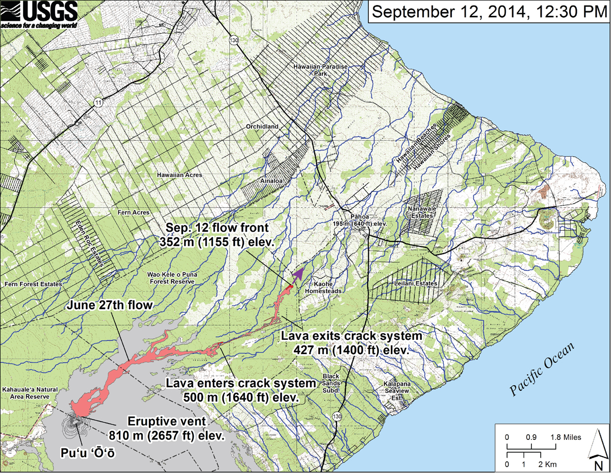
USGS HVO: “This small-scale map shows the June 27th flow in Kīlauea’s East Rift Zone on September 12, 2014. The area of the flow on September 10, 2014, at 2:45 PM is shown in pink, while widening and advancement of the flow as mapped on September 12 at 12:30 PM is shown in red. The front of the active flow was 14.9 km (9.3 miles; straight-line distance) from the vent and 0.17 km (0.1 miles) from the east boundary of the Wao Kele o Puna Forest Reserve. The actual length of the flow, measured along the lava tube axis (so that bends in the flow are considered) is 17.1 km (10.6 miles). The flow was advancing toward the northeast. The blue lines show down-slope paths calculated from a 1983 digital elevation model (DEM).”
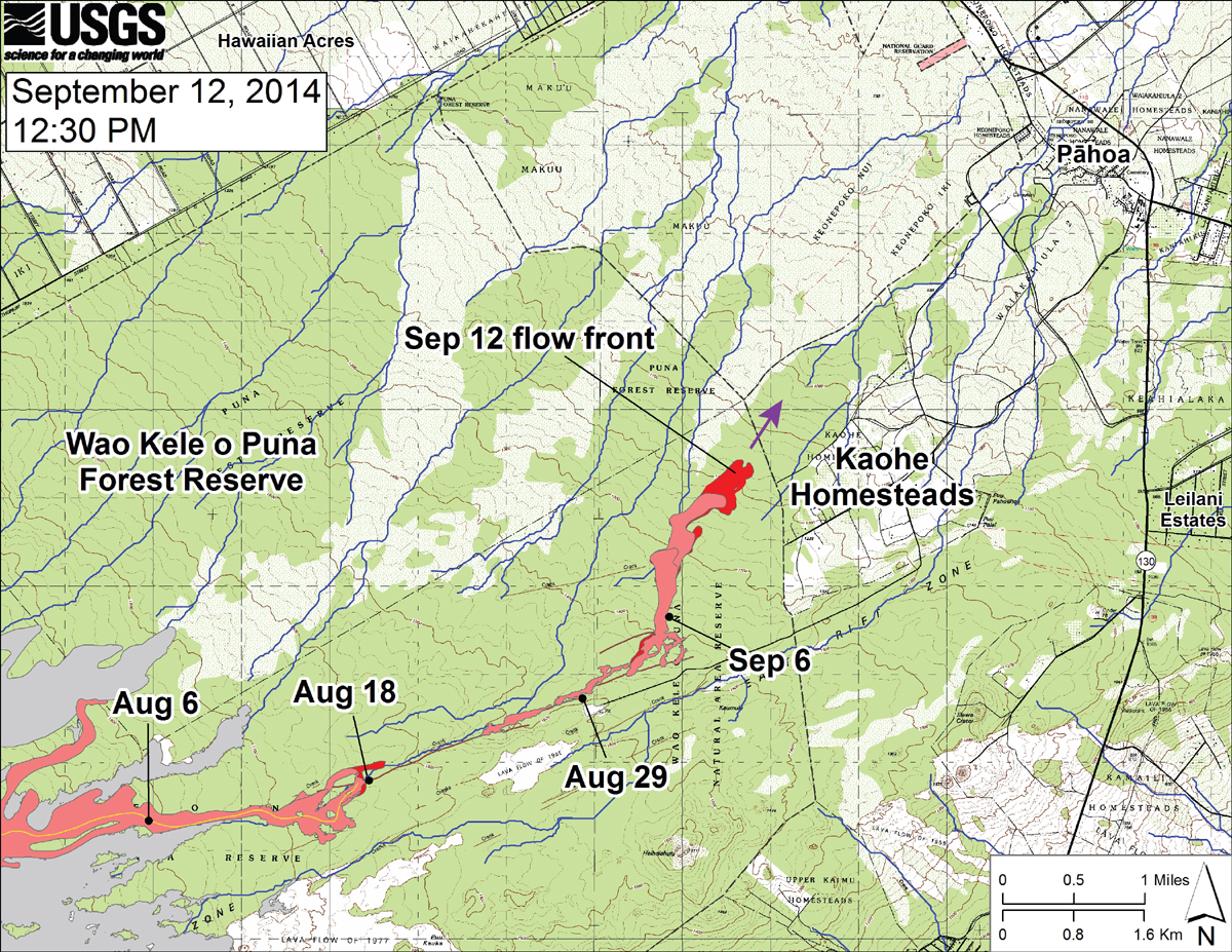
USGS HVO: “This large-scale map shows the distal part of the June 27th flow in relation to nearby Puna communities. The black dots mark the flow front on specific dates. The latitude and longitude of the flow front on September 12 was 19.46388/-154.98343 (Decimal degrees; WGS84). The blue lines show down-slope paths calculated from a 1983 digital elevation model.”
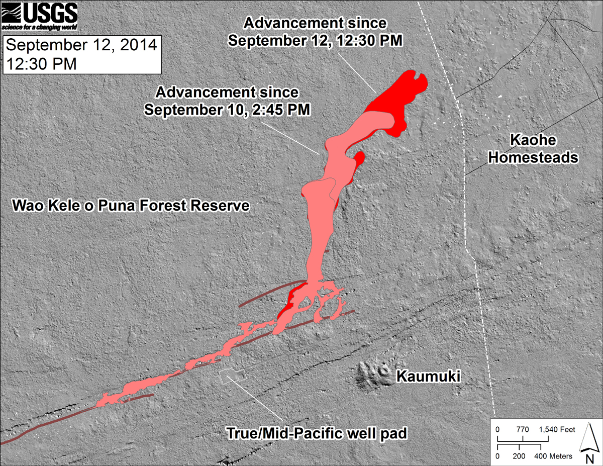
USGS HVO: “This shaded-relief map, with digital surface data provided by the Carnegie Airborne Observatory, shows some of the cracks, faults, and grabens (down-dropped blocks between adjacent faults; http://earthquake.usgs.gov/learn/glossary/?term=graben) that are present in Kīlauea’s East Rift Zone, and which have partly controlled the June 27th flow’s advance direction. The June 27th flow as of September 10, 2014, at 2:45 PM is shown in pink, while flow advance since then (as of ~12:30 PM on September 12) is shown in red. At the time of the mapping, the flow was advancing toward the northeast. “

by Big Island Video News
on at
STORY SUMMARY
The lava flow continues moving northeast and has nearly reached the boundary of the Kaohe Homesteads.