(ABOVE MAP) The USGS Hawaiian Volcano Observatory issued a new set of maps tracking the June 27 lava flow on Monday. This large-scale map shows the distal part of the flow in relation to nearby Puna communities. The area of the flow on September 6 at 11:10 a.m. is shown in pink, while widening and advancement of the flow as mapped on September 8 at 12:45 p.m. is shown in red. The black dots mark the flow front on specific dates.
PUNA, Hawaii – The June 27 lava flow continues to move north in the Wao Kele o Puna Forest Reserve, and could reach the government road in Pāhoa within 16-18 days. A new Volcanic Activity Notice was issued by the USGS Hawaiian Volcano Observatory on Monday evening.

Between September 6 and 8, the flow advanced northward at a rate of 400 m/d (1,300 ft/d). In this way, the flow had advanced approximately 13.7 km (8.5 miles straight-line distance) from the vent, or to within 1.2 km (0.7 miles) of the eastern boundary of the Wao Kele o Puna Forest Reserve, by the afternoon of September 8. At the average rate of advancement of 400 m/day (1,300 ft/day) since September 6, we project that lava could flow from its current location either through the north part of Kaohe Homesteads, or to the north of Kaohe Homesteads, and reach the government road in Pāhoa within 16-18 days if lava is not further confined within the cracks and down-dropped blocks within the East Rift Zone of Kīlauea volcano. These estimates will be continually refined as we track this lava flow.USGS Hawaiian Volcano Observatory at 5:01 p.m. September 8, 2014
Scientists also plotted the flow on some new maps Monday. Aside from the map at the top of this story, the USGS put together two more:
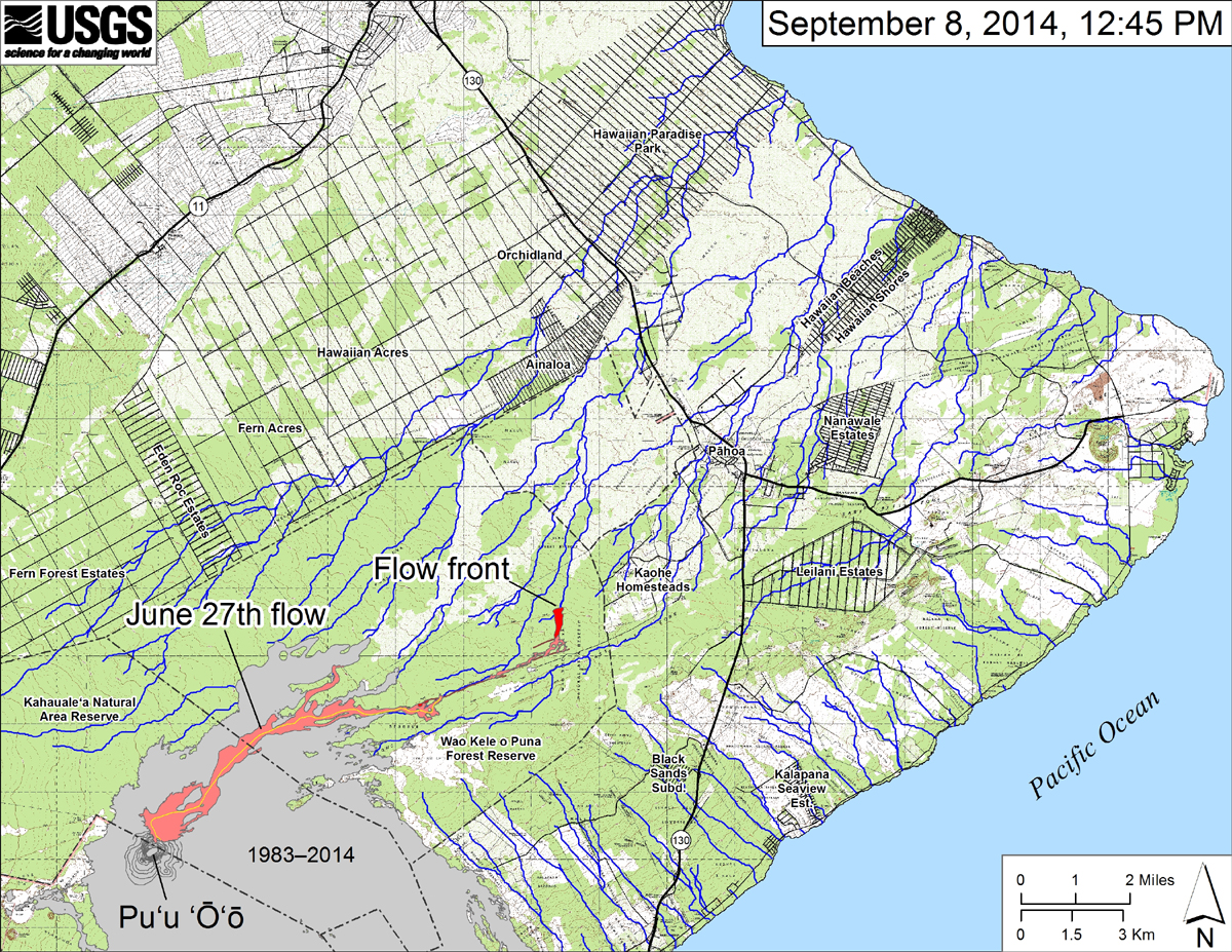
(USGS HVO) This small-scale map shows the June 27th flow in Kīlauea’s East Rift Zone as of September 8, 2014. The area of the flow on September 6 is shown in pink, while widening and advancement of the flow as mapped on September 8 at ~12:45 PM is shown in red. The front of the active flow was 13.7 km (8.5 miles; straight-line distance) from the vent and 1.2 km (0.7 miles) from the east boundary of the Wao Kele o Puna Forest Reserve. The flow was advancing toward the north, roughly parallel to the Forest Reserve boundary. The blue lines show down-slope paths calculated from a 1983 digital elevation model (DEM). For an explanation of down-slope path calculations, see: http://pubs.usgs.gov/of/2007/1264/. All older Puʻu ʻŌʻō lava flows (1983–2014) are shown in gray; the yellow line marks the lava tube.
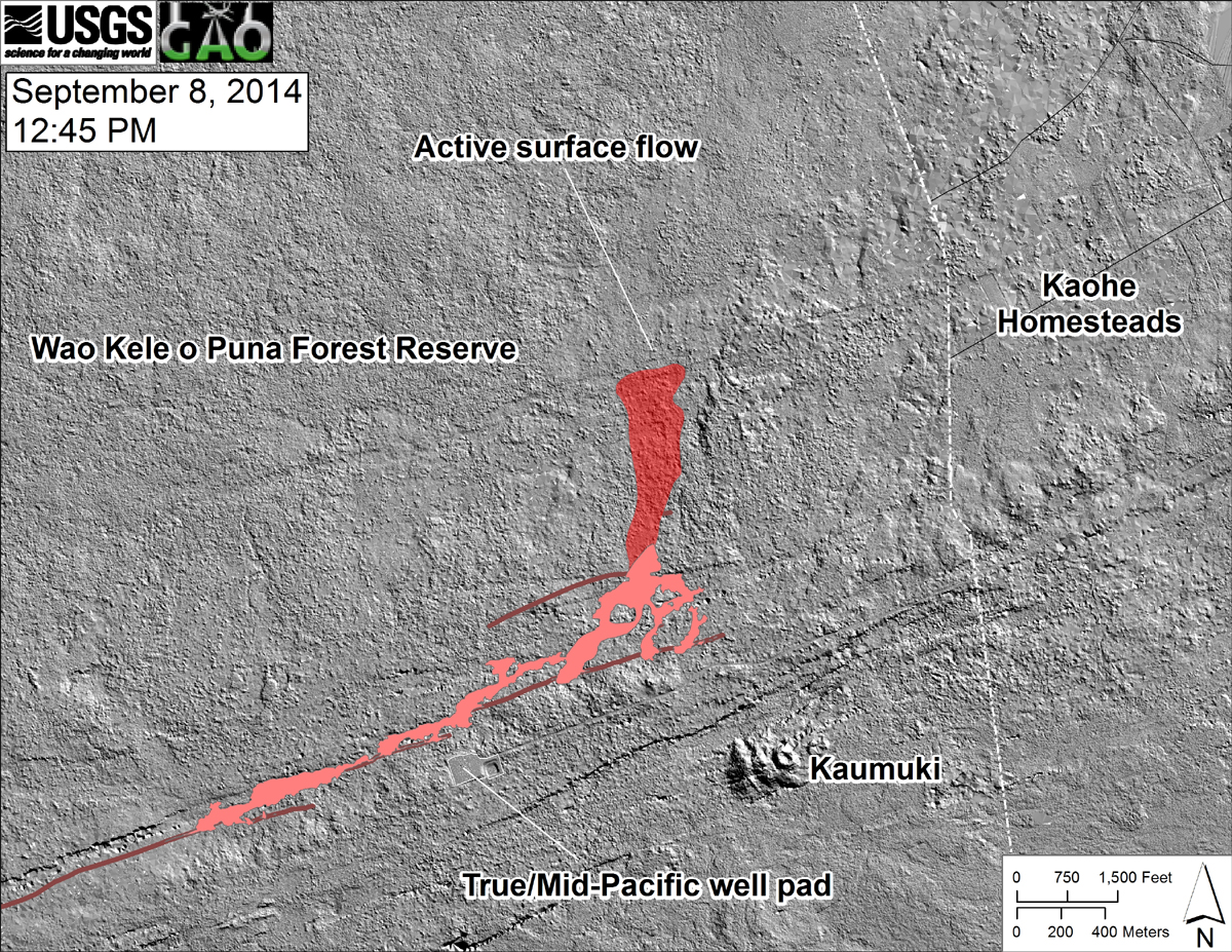
(USGS HVO) This shaded-relief map, courtesy of the Carnegie Airborne Observatory, shows some of the cracks, faults, and grabens (down-dropped blocks between adjacent faults; http://earthquake.usgs.gov/learn/glossary/?term=graben) that are present in Kīlauea’s East Rift Zone, and which have partly controlled the June 27th flow’s advance direction. The June 27th flow as of September 6 is shown in pink, while flow advance since then (as of ~12:45 PM on September 8) is partly transparent and shown in red. At the time of the mapping, the flow was advancing toward the north, and its front was at the location of the last obvious east-northeast-trending structure visible on the map.

by Big Island Video News
on at
STORY SUMMARY
The lava flow could reach the government road in Pāhoa within 16-18 days.