(ABOVE VIDEO) Hawaii County Civil Defense message issued around 11 a.m. with a video from a helicopter overflight filmed by Mick Kalber of Tropical Visions Video.
PUNA, Hawaii – Big Island Video News received some new video of the June 27 lava flow on Friday. Mick Kalber took the flight in the morning, and filmed the lava as it moved slowly through thick forest in the direction of Kaohe Homesteads near Pahoa.
We combined Kalber’s footage with the most recent Civil Defense message in the video above. Here is what officials said in the message, issued at 11:30 a.m. Friday:

Daily helicopter over flights and assessments are continuing. This morning’s assessment shows the surface lava flow continues and is moving very slowly in a east/northeast direction with very little vegetation burning. The surface flow has advanced approximately 150 yards since yesterday. Subsurface flow activity remains evident with the presence of steam plumes being emitted from the crack system. The surface flow is moving very slowly and does not pose an immediate threat to area residents. The surface flow is located approximately .8 miles southwest or upslope of the Wao Kele Puna Forest Reserve boundary and moving in an east/northeast direction.
Due to the proximity of the lava flow activity to the nearby residential areas, the Hawaii Volcanoes Observatory has elevated the eruption alert level to an Eruption Warning yesterday, Thursday September 4th. Presently, the current activities and flow does not present with an immediate or imminent threat to area communities. No evacuation is required at this time. Eruption activity will continue to be monitored and additional updates will be provided.
Although the current flow activity does not pose an immediate threat to area communities, residents are encouraged to continue to review their emergency plans in the event conditions change and should an evacuation be necessary.
The public is reminded that the flow cannot be accessed and is not visible from any public areas. Access to the Kaohe Homesteads subdivision will be restricted and limited to subdivision residents only. Hawaii County Civil Defense message for Sept. 5
Hawaii County Civil Defense and the Hawaiian Volcano Observatory will hold additional community meetings on Tuesday, Sept. 9 and Thursday, Sept. 11 to update residents on the lava flow in the Wao Kele O Puna area. The briefings will begin at 6:30 p.m. Tuesday and Thursday in the Pahoa High School Cafeteria. So far the meetings have been well attended to the point of standing room only.
On Friday evening, the USGS Hawaiian Volcano Observatory released new maps.
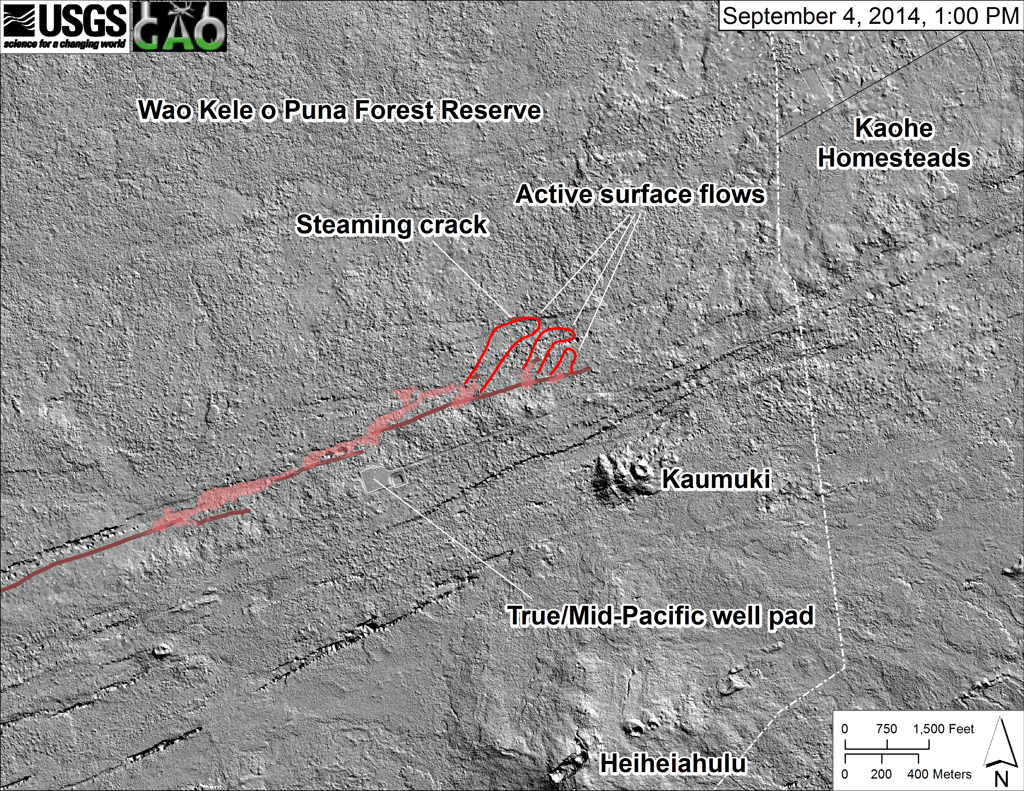
This shaded-relief map, courtesy of the Carnegie Airborne Observatory, shows some of the cracks and faults that are present in Kīlauea’s East Rift Zone. The June 27th flow is partly transparent and shown in pink, while the active surface lava at 1 PM on September 4 are outlined in red. The front of the western of these three pads of lava was entering another ground crack, which was steaming. (USGS HVO)
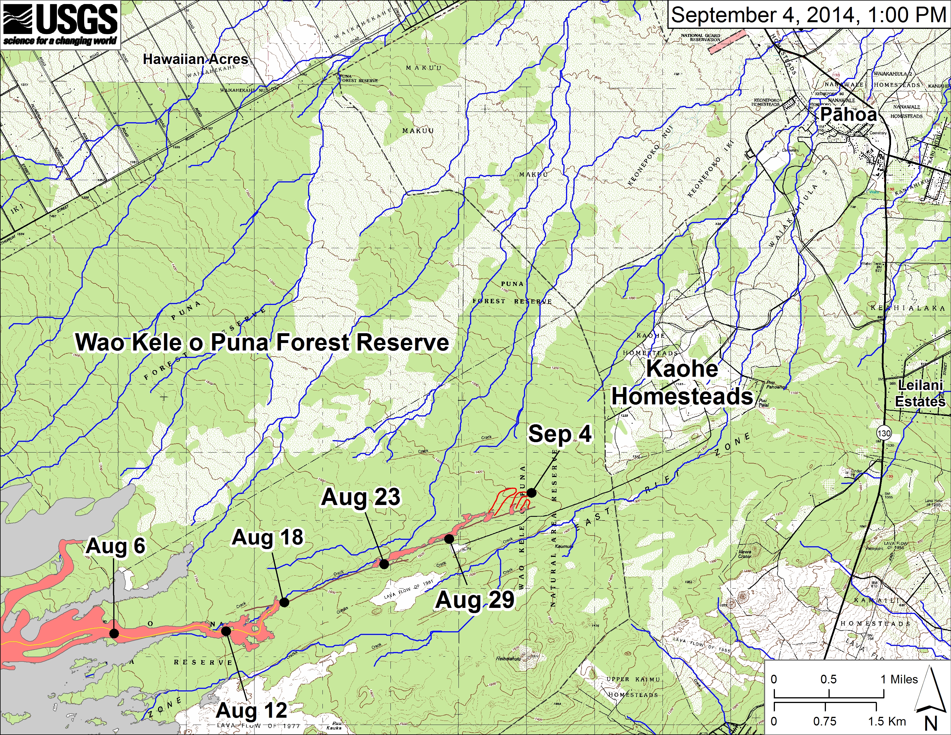
USGS HVO: Large-scale map showing the distal part of the June 27th flow in relation to nearby Puna communities. Flow advancement is illustrated with black dots which show the flow front on specific dates. The most distant surface lava at 1 PM on September 4, outlined in red, was 13.3 km (8.3 miles) from the vent and 1.2 km (0.7 miles) from the east boundary of the Wao Kele o Puna Forest Reserve. September 4 point Lat/Lon position: 19.446211/-154.990149 Decimal Degrees; WGS84. The blue lines show potential flow paths calculated from a 1983 digital elevation model (DEM; for calculation details, see http://pubs.usgs.gov/of/2007/1264/of2007-1264.pdf).
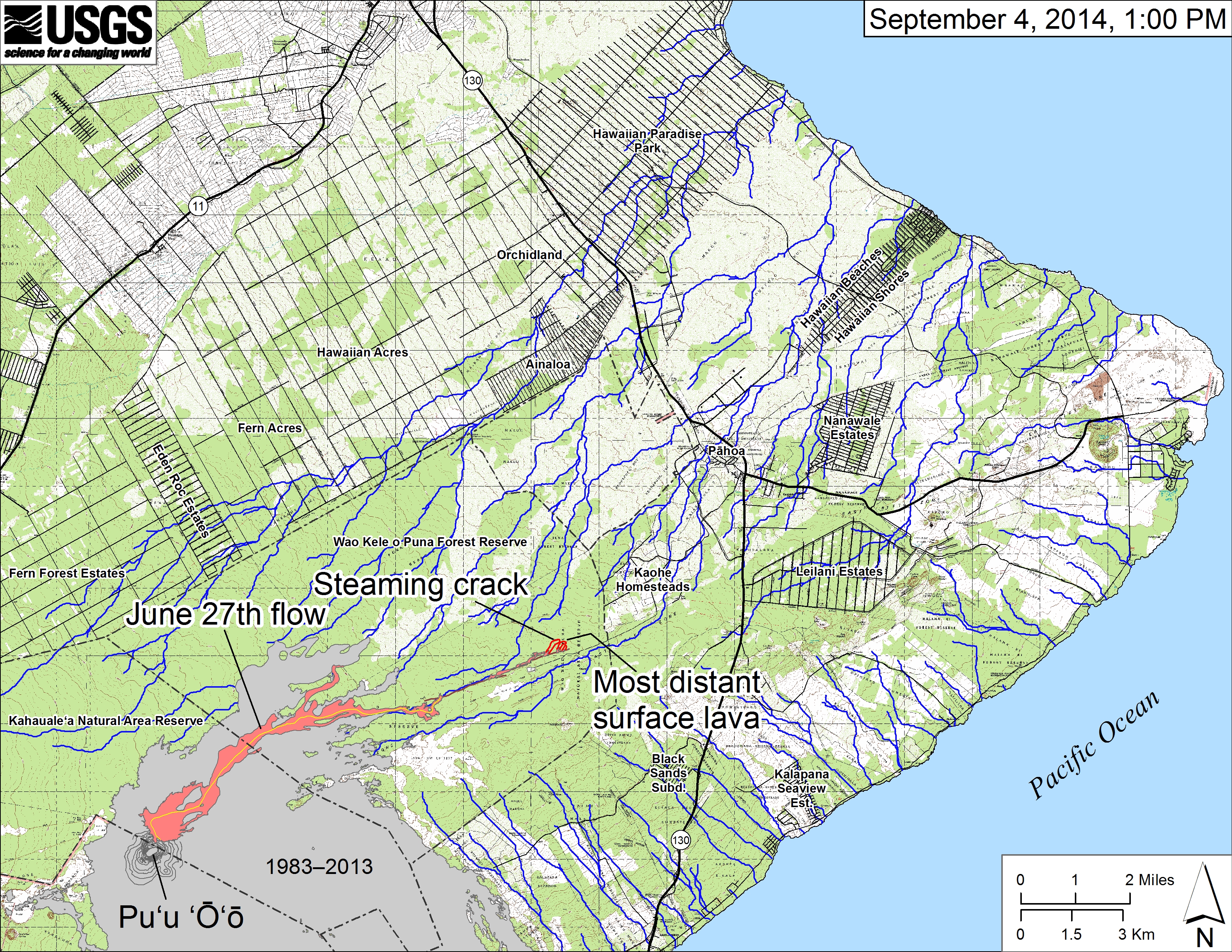
USGS HVO: Small-scale map showing the June 27th flow in Kīlauea’s East Rift Zone as of September 4, 2014. Lava on the surface at 1 PM, outlined in red, was 13.3 km (8.3 miles) from the vent and 1.2 km (0.7 miles) from the east boundary of the Wao Kele o Puna Forest Reserve. The front of the flow was spilling into another crack, which was steaming. The blue lines show potential flow paths calculated from a 1983 digital elevation model (DEM). All older lava flows (1983–2014) are shown in gray; the yellow line marks the lava tube. For an explanation of potential flow path calculations see: http://pubs.usgs.gov/of/2007/1264/.

by Big Island Video News
on at
STORY SUMMARY
Big Island Video News received some new video of the June 27 lava flow on Friday.